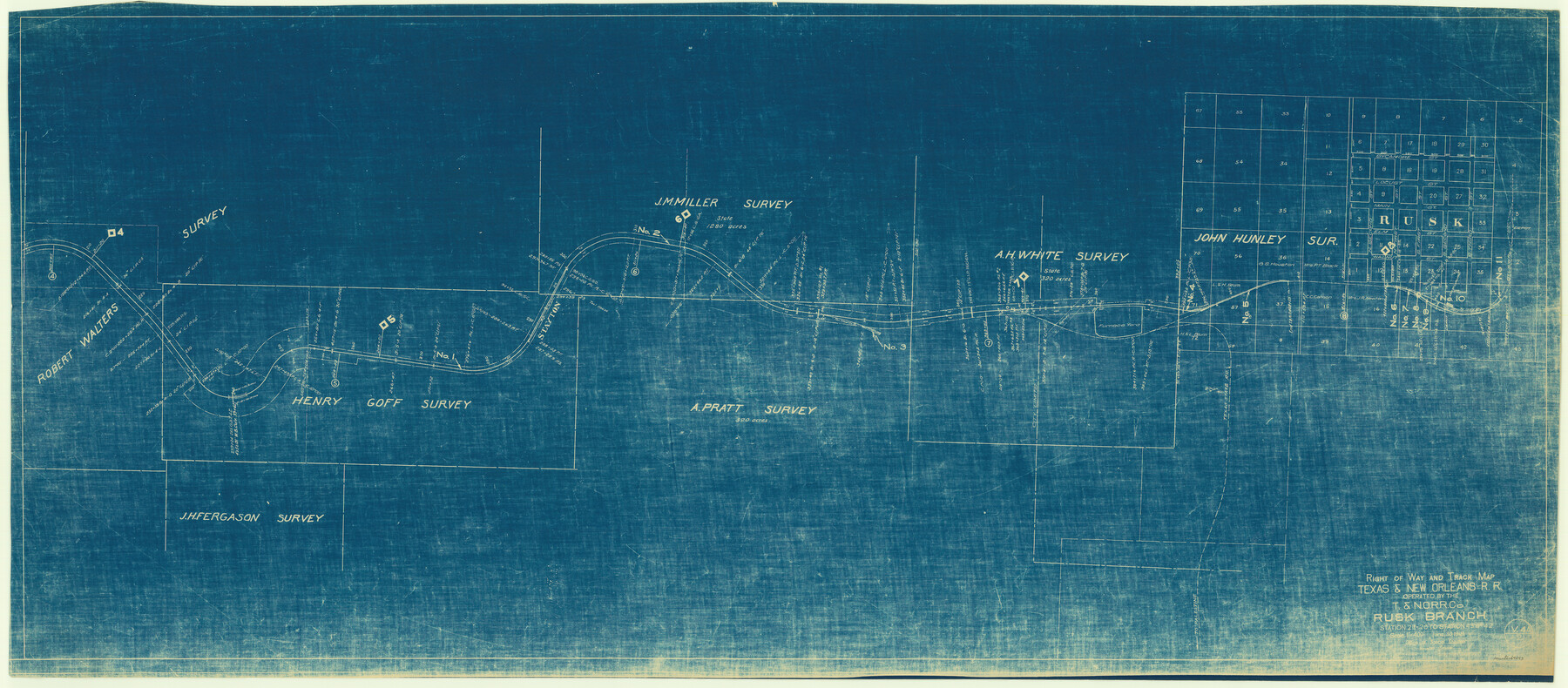
Right of Way and Track Map, Texas & New Orleans R.R. operated by the T. & N. O. R.R. Co., Rusk Branch
Station 211+20 to Station 438+42
Z-2-60
-
Map/Doc
64243
-
Collection
General Map Collection
-
Object Dates
1927/12/31 (Revision Date)
1918/6/30 (Creation Date)
-
People and Organizations
Office of Special Engineer (Publisher)
-
Counties
Cherokee
-
Subjects
Railroads
-
Height x Width
24.7 x 56.2 inches
62.7 x 142.7 cm
-
Medium
blueprint/diazo
-
Scale
1" = 400'
-
Comments
See counter no. 64242 for sheet 1.
-
Features
TSR
T&NO
Rusk
Stayton
Checkup
Part of: General Map Collection
Bastrop County Sketch File 1a

Print $4.00
- Digital $50.00
Bastrop County Sketch File 1a
Size 8.4 x 12.8 inches
Map/Doc 14040
Map of the country adjacent to the left bank of the Rio Grande below Matamoros

Print $20.00
- Digital $50.00
Map of the country adjacent to the left bank of the Rio Grande below Matamoros
1847
Size 18.3 x 27.3 inches
Map/Doc 72868
Jones County Sketch File 10a

Print $40.00
- Digital $50.00
Jones County Sketch File 10a
1875
Size 40.0 x 50.6 inches
Map/Doc 10509
Campbell's Addition to El Paso, Texas

Print $20.00
- Digital $50.00
Campbell's Addition to El Paso, Texas
1885
Size 43.5 x 43.1 inches
Map/Doc 8854
Current Miscellaneous File 12

Print $34.00
- Digital $50.00
Current Miscellaneous File 12
1951
Size 10.7 x 8.2 inches
Map/Doc 73803
A New Map of Texas, Oregon, and California with the regions adjoining compiled from the most recent authorities

Print $20.00
- Digital $50.00
A New Map of Texas, Oregon, and California with the regions adjoining compiled from the most recent authorities
1846
Size 23.0 x 21.2 inches
Map/Doc 95748
Rebel Defenses of Galveston and Vicinity

Print $20.00
- Digital $50.00
Rebel Defenses of Galveston and Vicinity
1865
Size 17.0 x 23.7 inches
Map/Doc 61802
[Surveys in McMullen and McGloin's Colony along the San Antonio River]
![30, [Surveys in McMullen and McGloin's Colony along the San Antonio River], General Map Collection](https://historictexasmaps.com/wmedia_w700/maps/30-1.tif.jpg)
Print $20.00
- Digital $50.00
[Surveys in McMullen and McGloin's Colony along the San Antonio River]
1828
Size 19.3 x 24.5 inches
Map/Doc 30
Terrell County Working Sketch 51

Print $40.00
- Digital $50.00
Terrell County Working Sketch 51
1958
Size 63.7 x 43.6 inches
Map/Doc 62144
Howard County Working Sketch 1

Print $20.00
- Digital $50.00
Howard County Working Sketch 1
1941
Size 19.7 x 25.1 inches
Map/Doc 66267
Map of Navarro County

Print $20.00
- Digital $50.00
Map of Navarro County
1872
Size 17.6 x 22.6 inches
Map/Doc 3911
Zavala County Sketch File 11a

Print $10.00
- Digital $50.00
Zavala County Sketch File 11a
1885
Size 11.2 x 8.6 inches
Map/Doc 41272
You may also like
Presidio County Sketch File 70a

Print $6.00
- Digital $50.00
Presidio County Sketch File 70a
1923
Size 17.0 x 11.0 inches
Map/Doc 34669
Flight Mission No. DIX-10P, Frame 74, Aransas County

Print $20.00
- Digital $50.00
Flight Mission No. DIX-10P, Frame 74, Aransas County
1956
Size 18.7 x 22.4 inches
Map/Doc 83935
Flight Mission No. BRE-2P, Frame 48, Nueces County

Print $20.00
- Digital $50.00
Flight Mission No. BRE-2P, Frame 48, Nueces County
1956
Size 18.5 x 22.3 inches
Map/Doc 86750
Brewster County Rolled Sketch 114

Print $20.00
- Digital $50.00
Brewster County Rolled Sketch 114
1964
Size 17.3 x 11.4 inches
Map/Doc 5292
Freestone County Sketch File 15

Print $4.00
- Digital $50.00
Freestone County Sketch File 15
Size 6.3 x 8.2 inches
Map/Doc 23070
Harrison County State Real Property Sketch 1

Print $20.00
- Digital $50.00
Harrison County State Real Property Sketch 1
1986
Size 24.2 x 25.4 inches
Map/Doc 61666
Refugio County Boundary File 3

Print $4.00
- Digital $50.00
Refugio County Boundary File 3
Size 14.0 x 8.7 inches
Map/Doc 58244
Shelby County Sketch File 9

Print $4.00
- Digital $50.00
Shelby County Sketch File 9
1858
Size 9.4 x 8.2 inches
Map/Doc 36609

Flight Mission No. CUG-2P, Frame 87, Kleberg County

Print $20.00
- Digital $50.00
Flight Mission No. CUG-2P, Frame 87, Kleberg County
1956
Size 18.4 x 22.2 inches
Map/Doc 86219
Cameron County Rolled Sketch 25

Print $20.00
- Digital $50.00
Cameron County Rolled Sketch 25
1977
Size 24.8 x 36.6 inches
Map/Doc 5798
General Highway Map, Culberson County, Texas

Print $20.00
General Highway Map, Culberson County, Texas
1961
Size 24.9 x 18.2 inches
Map/Doc 79427