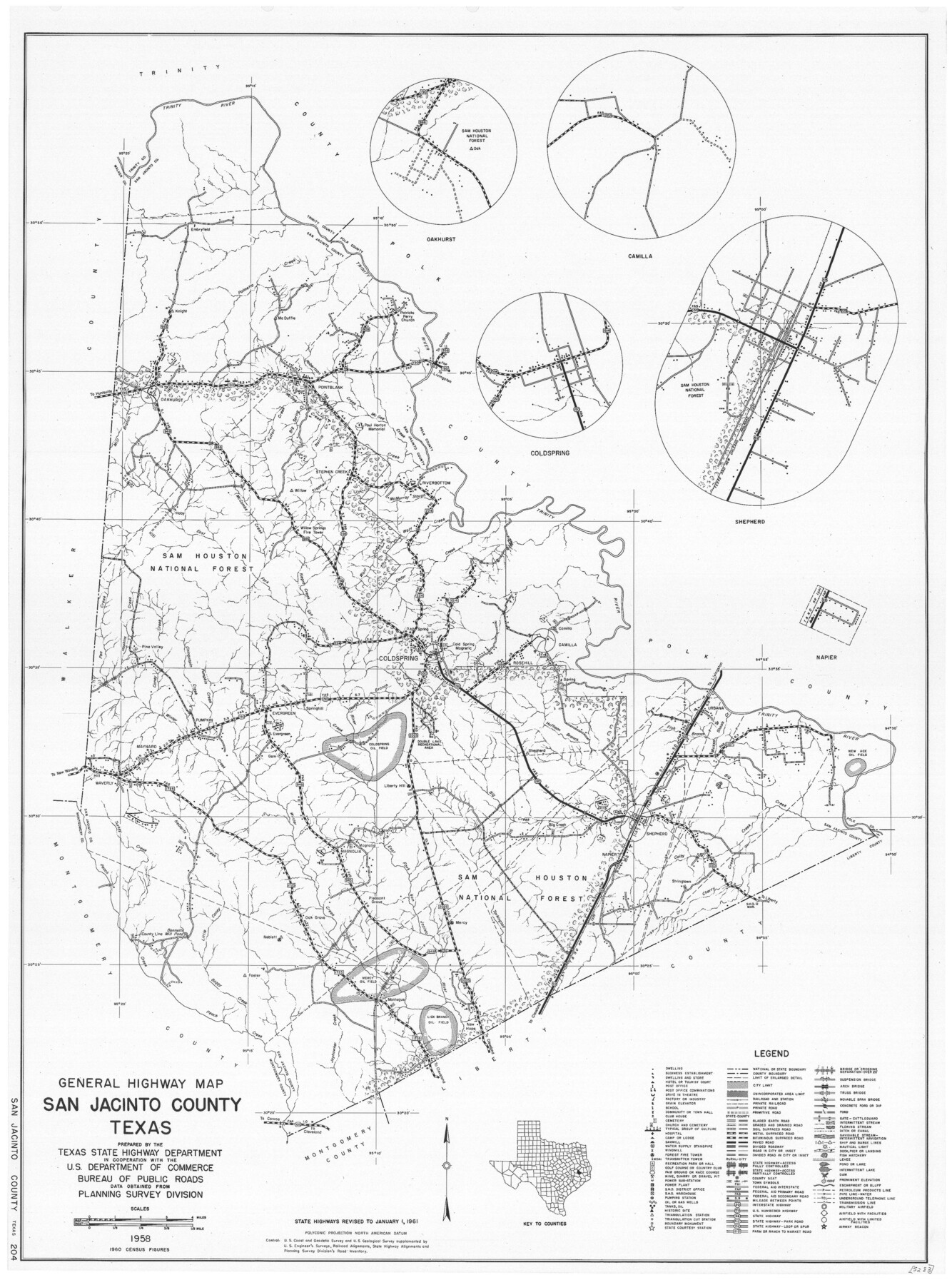
General Highway Map, San Jacinto County, Texas
-
Map/Doc
79646
-
Collection
Texas State Library and Archives
-
Object Dates
1961 (Creation Date)
-
People and Organizations
Texas State Highway Department (Publisher)
-
Counties
San Jacinto
-
Subjects
County
-
Height x Width
24.6 x 18.4 inches
62.5 x 46.7 cm
-
Comments
Prints available courtesy of the Texas State Library and Archives.
More info can be found here: TSLAC Map 05283
Part of: Texas State Library and Archives
General Highway Map, Harris County, Texas

Print $20.00
General Highway Map, Harris County, Texas
1939
Size 25.3 x 18.7 inches
Map/Doc 79116
General Highway Map, Mitchell County, Texas

Print $20.00
General Highway Map, Mitchell County, Texas
1961
Size 18.1 x 24.6 inches
Map/Doc 79600
General Highway Map, Dickens County, Texas

Print $20.00
General Highway Map, Dickens County, Texas
1940
Size 18.3 x 25.3 inches
Map/Doc 79076
General Highway Map, Walker County, Texas

Print $20.00
General Highway Map, Walker County, Texas
1961
Size 24.7 x 18.1 inches
Map/Doc 79698
General Highway Map. Detail of Cities and Towns in Travis County, Texas [Austin]
![79262, General Highway Map. Detail of Cities and Towns in Travis County, Texas [Austin], Texas State Library and Archives](https://historictexasmaps.com/wmedia_w700/maps/79262-1.tif.jpg)
Print $20.00
General Highway Map. Detail of Cities and Towns in Travis County, Texas [Austin]
1940
Size 18.2 x 25.0 inches
Map/Doc 79262
General Highway Map. Detail of Cities and Towns in Montgomery County, Texas

Print $20.00
General Highway Map. Detail of Cities and Towns in Montgomery County, Texas
1961
Size 18.1 x 24.5 inches
Map/Doc 79603
General Highway Map, Colorado County, Texas

Print $20.00
General Highway Map, Colorado County, Texas
1961
Size 25.1 x 18.3 inches
Map/Doc 79416
General Highway Map. Detail of Cities and Towns in Tarrant County, Texas. City Map, Fort Worth and vicinity, Tarrant County, Texas

Print $20.00
General Highway Map. Detail of Cities and Towns in Tarrant County, Texas. City Map, Fort Worth and vicinity, Tarrant County, Texas
1961
Size 18.2 x 24.9 inches
Map/Doc 79671
General Highway Map. Detail of Cities and Towns in Milam County, Texas [Rockdale and Cameron and vicinities]
![79598, General Highway Map. Detail of Cities and Towns in Milam County, Texas [Rockdale and Cameron and vicinities], Texas State Library and Archives](https://historictexasmaps.com/wmedia_w700/maps/79598.tif.jpg)
Print $20.00
General Highway Map. Detail of Cities and Towns in Milam County, Texas [Rockdale and Cameron and vicinities]
1961
Size 18.1 x 24.6 inches
Map/Doc 79598
General Highway Map, Kendall County, Texas

Print $20.00
General Highway Map, Kendall County, Texas
1940
Size 18.4 x 24.7 inches
Map/Doc 79153
General Highway Map, Menard County, Texas

Print $20.00
General Highway Map, Menard County, Texas
1940
Size 18.5 x 24.8 inches
Map/Doc 79196
General Highway Map, Runnels County, Texas

Print $20.00
General Highway Map, Runnels County, Texas
1961
Size 24.6 x 18.2 inches
Map/Doc 79642
You may also like
Flight Mission No. BRA-16M, Frame 54, Jefferson County

Print $20.00
- Digital $50.00
Flight Mission No. BRA-16M, Frame 54, Jefferson County
1953
Size 18.5 x 22.5 inches
Map/Doc 85671
University Lands Situated in Robertson County

Print $20.00
- Digital $50.00
University Lands Situated in Robertson County
1841
Size 22.8 x 26.2 inches
Map/Doc 281
Reeves County Working Sketch 40

Print $40.00
- Digital $50.00
Reeves County Working Sketch 40
1973
Size 66.0 x 39.2 inches
Map/Doc 63483
Oldham County

Print $40.00
- Digital $50.00
Oldham County
1925
Size 43.6 x 53.5 inches
Map/Doc 66960
Hudspeth County Sketch File 2

Print $10.00
- Digital $50.00
Hudspeth County Sketch File 2
1900
Size 13.4 x 8.6 inches
Map/Doc 26884
Flight Mission No. DCL-6C, Frame 98, Kenedy County

Print $20.00
- Digital $50.00
Flight Mission No. DCL-6C, Frame 98, Kenedy County
1943
Size 18.6 x 22.3 inches
Map/Doc 85928
Hockley County Sketch File 15

Print $6.00
- Digital $50.00
Hockley County Sketch File 15
1912
Size 11.4 x 8.9 inches
Map/Doc 26550
[Township 3 North, Blocks 33 and 34, T. & P. RR. Company; Township 4 North, Block 33, T. & P. RR. Company]
![92564, [Township 3 North, Blocks 33 and 34, T. & P. RR. Company; Township 4 North, Block 33, T. & P. RR. Company], Twichell Survey Records](https://historictexasmaps.com/wmedia_w700/maps/92564-1.tif.jpg)
Print $20.00
- Digital $50.00
[Township 3 North, Blocks 33 and 34, T. & P. RR. Company; Township 4 North, Block 33, T. & P. RR. Company]
1911
Size 18.6 x 24.8 inches
Map/Doc 92564
Leila Y. Post Montgomery & Marjorie Post Hutton's Subdivision of Hall County School Land Leagues 158-159-N 1/2 157, Cochran County, Texas

Print $20.00
- Digital $50.00
Leila Y. Post Montgomery & Marjorie Post Hutton's Subdivision of Hall County School Land Leagues 158-159-N 1/2 157, Cochran County, Texas
Size 8.4 x 18.4 inches
Map/Doc 90456
Denton County Working Sketch 2

Print $20.00
- Digital $50.00
Denton County Working Sketch 2
Size 21.2 x 17.7 inches
Map/Doc 68607
Refugio County Boundary File 2a

Print $8.00
- Digital $50.00
Refugio County Boundary File 2a
Size 14.5 x 9.1 inches
Map/Doc 58240
Flight Mission No. BRA-17M, Frame 12, Jefferson County

Print $20.00
- Digital $50.00
Flight Mission No. BRA-17M, Frame 12, Jefferson County
1953
Size 18.5 x 22.3 inches
Map/Doc 85793