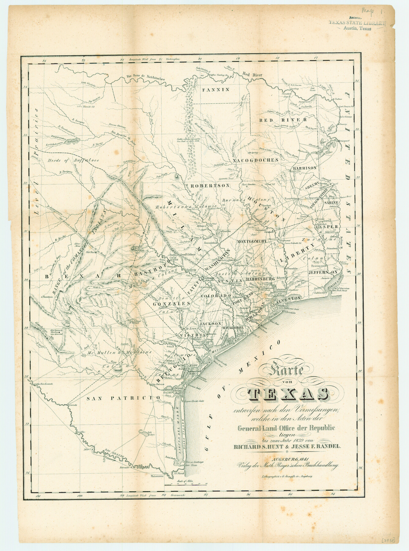
Karte von Texas entworfen nach den Vermessungen, welche in den Acten der General-Land-Office der Republic liegen bis zum Jahr 1839 von Richard S. Hunt & Jesse F. Randel
-
Map/Doc
79311
-
Collection
Texas State Library and Archives
-
Object Dates
1841 (Creation Date)
-
People and Organizations
Math. Rieger’schen Buchhandlung (Publisher)
G. Stempfle (Printer)
-
Subjects
Republic of Texas
-
Height x Width
19.6 x 14.6 inches
49.8 x 37.1 cm
-
Comments
Prints available courtesy of the Texas State Library and Archives.
More info can be found here: TSLAC Map 03938
Part of: Texas State Library and Archives
General Highway Map. Detail of Cities and Towns in Bee County, Texas. City Map of Beeville, Bee County, Texas

Print $20.00
General Highway Map. Detail of Cities and Towns in Bee County, Texas. City Map of Beeville, Bee County, Texas
1961
Size 25.0 x 18.2 inches
Map/Doc 79365
New Map of the State of Texas compiled from the latest authorities

Print $20.00
New Map of the State of Texas compiled from the latest authorities
1877
Size 19.1 x 21.4 inches
Map/Doc 79300
General Highway Map, Orange County, Texas

Print $20.00
General Highway Map, Orange County, Texas
1940
Size 18.3 x 24.5 inches
Map/Doc 79212
General Highway Map. Detail of Cities and Towns in Walker County, Texas [Huntsville and vicinity]
![79699, General Highway Map. Detail of Cities and Towns in Walker County, Texas [Huntsville and vicinity], Texas State Library and Archives](https://historictexasmaps.com/wmedia_w700/maps/79699.tif.jpg)
Print $20.00
General Highway Map. Detail of Cities and Towns in Walker County, Texas [Huntsville and vicinity]
1961
Size 18.1 x 24.8 inches
Map/Doc 79699
General Highway Map, Culberson County, Texas

Print $20.00
General Highway Map, Culberson County, Texas
1940
Size 25.2 x 18.5 inches
Map/Doc 79064
General Highway Map, Dickens County, Texas

Print $20.00
General Highway Map, Dickens County, Texas
1961
Size 18.2 x 24.9 inches
Map/Doc 79443
Topographic Map of Big Bend Area

Print $20.00
Topographic Map of Big Bend Area
1923
Size 47.1 x 35.0 inches
Map/Doc 79757
General Highway Map, Caldwell County, Texas

Print $20.00
General Highway Map, Caldwell County, Texas
1940
Size 18.5 x 25.2 inches
Map/Doc 79034
General Highway Map, Ellis County, Texas

Print $20.00
General Highway Map, Ellis County, Texas
1961
Size 18.2 x 24.6 inches
Map/Doc 79453
General Highway Map. Detail of Cities and Towns in Hale County, Texas [Plainview and vicinity]
![79494, General Highway Map. Detail of Cities and Towns in Hale County, Texas [Plainview and vicinity], Texas State Library and Archives](https://historictexasmaps.com/wmedia_w700/maps/79494.tif.jpg)
Print $20.00
General Highway Map. Detail of Cities and Towns in Hale County, Texas [Plainview and vicinity]
1961
Size 24.6 x 18.2 inches
Map/Doc 79494
General Highway Map. Detail of Cities and Towns in Brown County, Texas [Brownwood and vicinity]
![79390, General Highway Map. Detail of Cities and Towns in Brown County, Texas [Brownwood and vicinity], Texas State Library and Archives](https://historictexasmaps.com/wmedia_w700/maps/79390.tif.jpg)
Print $20.00
General Highway Map. Detail of Cities and Towns in Brown County, Texas [Brownwood and vicinity]
1961
Size 24.8 x 18.2 inches
Map/Doc 79390
General Highway Map, Marion County, Texas

Print $20.00
General Highway Map, Marion County, Texas
1961
Size 18.2 x 24.6 inches
Map/Doc 79582
You may also like
Flight Mission No. BRA-7M, Frame 123, Jefferson County

Print $20.00
- Digital $50.00
Flight Mission No. BRA-7M, Frame 123, Jefferson County
1953
Size 18.7 x 22.3 inches
Map/Doc 85517
Map Location of the Pecos & Northern Texas Railway from [illegible] through Deaf Smith County
![64180, Map Location of the Pecos & Northern Texas Railway from [illegible] through Deaf Smith County, General Map Collection](https://historictexasmaps.com/wmedia_w700/maps/64180-1.tif.jpg)
Print $40.00
- Digital $50.00
Map Location of the Pecos & Northern Texas Railway from [illegible] through Deaf Smith County
Size 16.3 x 71.8 inches
Map/Doc 64180
Comanche County Boundary File 2a

Print $4.00
- Digital $50.00
Comanche County Boundary File 2a
Size 14.3 x 8.8 inches
Map/Doc 51788
Nueces County Sketch File 32

Print $32.00
- Digital $50.00
Nueces County Sketch File 32
1907
Size 14.2 x 8.7 inches
Map/Doc 32605
[Map of Lubbock showing Sears Addition, Sunset Place, Loma Linda Place, University Place, Webb Addition, Ellwood Place, Del Mar Addition and Del Mar Annex]
![92729, [Map of Lubbock showing Sears Addition, Sunset Place, Loma Linda Place, University Place, Webb Addition, Ellwood Place, Del Mar Addition and Del Mar Annex], Twichell Survey Records](https://historictexasmaps.com/wmedia_w700/maps/92729-1.tif.jpg)
Print $20.00
- Digital $50.00
[Map of Lubbock showing Sears Addition, Sunset Place, Loma Linda Place, University Place, Webb Addition, Ellwood Place, Del Mar Addition and Del Mar Annex]
Size 30.8 x 30.8 inches
Map/Doc 92729
Edwards County Sketch File 32

Print $40.00
- Digital $50.00
Edwards County Sketch File 32
1926
Size 13.1 x 14.4 inches
Map/Doc 21765
Nueces County Rolled Sketch 123

Print $20.00
- Digital $50.00
Nueces County Rolled Sketch 123
1997
Size 18.2 x 24.9 inches
Map/Doc 7158
Orange County Working Sketch 49

Print $20.00
- Digital $50.00
Orange County Working Sketch 49
1991
Size 29.7 x 31.8 inches
Map/Doc 71381
Jeff Davis County Boundary File 1a

Print $8.00
- Digital $50.00
Jeff Davis County Boundary File 1a
Size 14.3 x 8.8 inches
Map/Doc 55501
General Highway Map, Mason County, Texas

Print $20.00
General Highway Map, Mason County, Texas
1961
Size 18.3 x 24.8 inches
Map/Doc 79584
General Highway Map, Stephens County, Texas

Print $20.00
General Highway Map, Stephens County, Texas
1961
Size 25.0 x 18.2 inches
Map/Doc 79660
Shelby County Sketch File 23

Print $5.00
- Digital $50.00
Shelby County Sketch File 23
Size 16.2 x 7.3 inches
Map/Doc 36645