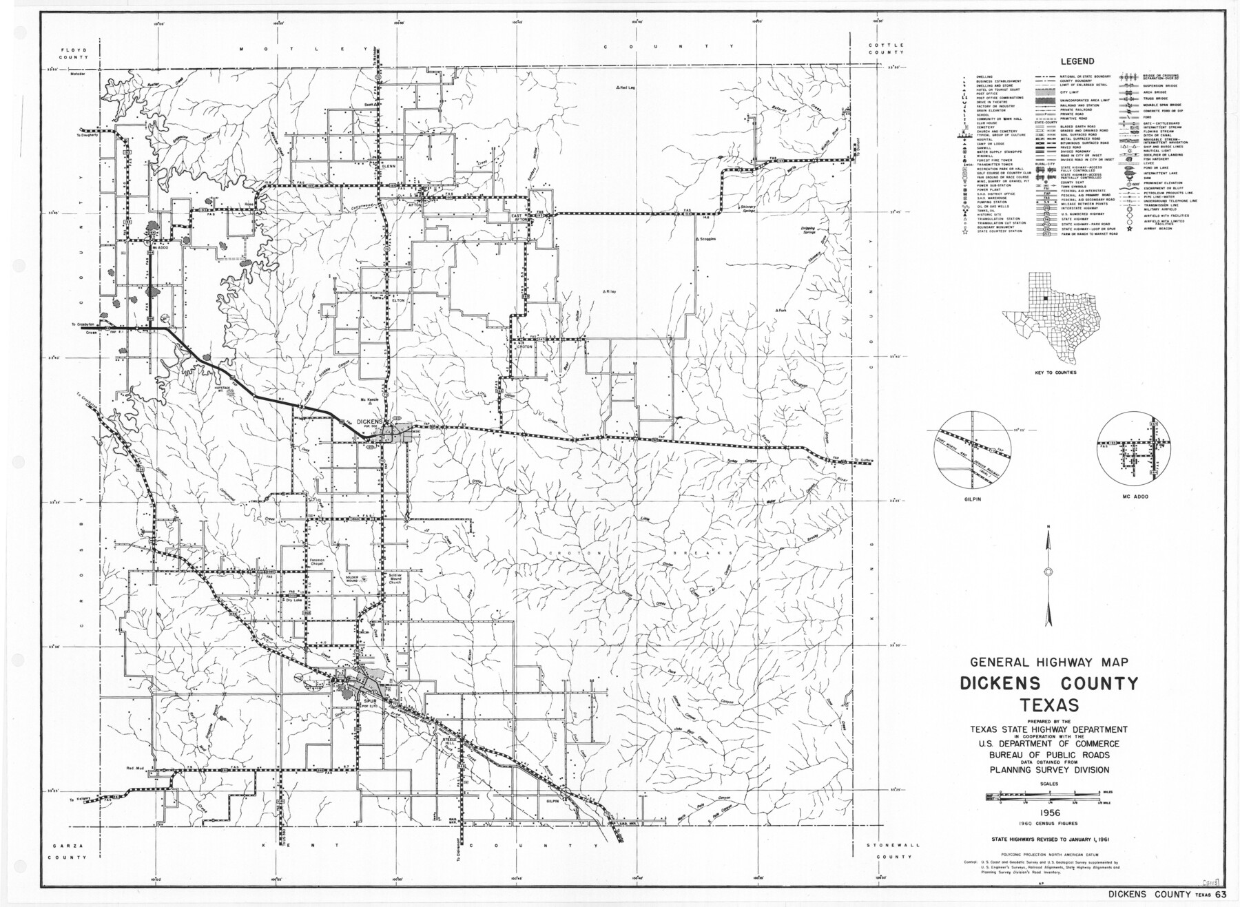
General Highway Map, Dickens County, Texas
- 
                          Map/Doc
79443
 - 
                            Collection
Texas State Library and Archives
 - 
                            Object Dates
1961 (Creation Date)
 - 
                            People and Organizations
Texas State Highway Department (Publisher)
 - 
                            Counties
Dickens
 - 
                            Subjects
County
 - 
                            Height x Width
18.2 x 24.9 inches
46.2 x 63.3 cm
 - 
                            Comments
Prints available courtesy of the Texas State Library and Archives.
More info can be found here: TSLAC Map 05113 
Part of: Texas State Library and Archives
            Sectional Map of Texas Traversed by the Missouri, Kansas, and Texas Railway Showing the crops adapted to each section, with the elevation and annual rainfall.


                                            Print $20.00                    
                                    
                Sectional Map of Texas Traversed by the Missouri, Kansas, and Texas Railway Showing the crops adapted to each section, with the elevation and annual rainfall.
1909
Size 21.8 x 22.9 inches
                                Map/Doc 76265
            
            General Highway Map, Hansford County, Texas


                                            Print $20.00                    
                                    
                General Highway Map, Hansford County, Texas
1961
Size 18.0 x 24.5 inches
                                Map/Doc 79497
            
            General Highway Map, Hardin County, Texas


                                            Print $20.00                    
                                    
                General Highway Map, Hardin County, Texas
1940
Size 18.4 x 24.8 inches
                                Map/Doc 79114
            
            Stremme General Land Office Drawings, front door


                                            Print $20.00                    
                                    
                Stremme General Land Office Drawings, front door
Size 27.4 x 21.9 inches
                                Map/Doc 79737
            
            General Highway Map, Llano County, Texas


                                            Print $20.00                    
                                    
                General Highway Map, Llano County, Texas
1961
Size 18.2 x 24.6 inches
                                Map/Doc 79576
            
            General Highway Map.  Detail of Cities and Towns in Galveston County, Texas [Galveston and vicinity]


                                            Print $20.00                    
                                    
                General Highway Map. Detail of Cities and Towns in Galveston County, Texas [Galveston and vicinity]
1939
Size 18.4 x 25.0 inches
                                Map/Doc 79097
            
            General Highway Map, Kinney County, Uvalde County, Texas


                                            Print $20.00                    
                                    
                General Highway Map, Kinney County, Uvalde County, Texas
1940
Size 18.4 x 24.8 inches
                                Map/Doc 79162
            
            Traveller's Map of the State of Texas


                                            Print $20.00                    
                                    
                Traveller's Map of the State of Texas
1867
Size 42.5 x 41.1 inches
                                Map/Doc 76226
            
            General Highway Map.  Detail of Cities and Towns in Hill County, Texas


                                            Print $20.00                    
                                    
                General Highway Map. Detail of Cities and Towns in Hill County, Texas
1961
Size 18.1 x 24.7 inches
                                Map/Doc 79521
            
            General Highway Map.  Detail of Cities and Towns in Jefferson County, Texas [Beaumont-Port Arthur vicinity]


                                            Print $20.00                    
                                    
                General Highway Map. Detail of Cities and Towns in Jefferson County, Texas [Beaumont-Port Arthur vicinity]
1940
Size 24.8 x 18.3 inches
                                Map/Doc 79145
            
            Geological Petroleum Corporation Map of North Central Texas


                                            Print $20.00                    
                                    
                Geological Petroleum Corporation Map of North Central Texas
1920
Size 37.4 x 28.4 inches
                                Map/Doc 79305
            
            Karte von Texas entworfen nach den Vermessungen, welche in den Acten der General-Land-Office der Republic liegen bis zum Jahr 1839 von Richard S. Hunt & Jesse F. Randel


                                            Print $20.00                    
                                    
                Karte von Texas entworfen nach den Vermessungen, welche in den Acten der General-Land-Office der Republic liegen bis zum Jahr 1839 von Richard S. Hunt & Jesse F. Randel
1841
Size 19.6 x 14.6 inches
                                Map/Doc 79311
            You may also like
            Jefferson County Rolled Sketch 61C


                                            Print $20.00                    
                                             -                         Digital $50.00                                    
                Jefferson County Rolled Sketch 61C
1928
Size 27.2 x 40.3 inches
                                Map/Doc 6412
            
            Waller County Working Sketch 2


                                            Print $20.00                    
                                             -                         Digital $50.00                                    
                Waller County Working Sketch 2
1955
Size 19.5 x 18.8 inches
                                Map/Doc 72301
            
            Middle Sulphur and South Sulphur Rivers, Horton Sheet


                                            Print $20.00                    
                                             -                         Digital $50.00                                    
                Middle Sulphur and South Sulphur Rivers, Horton Sheet
1925
Size 42.2 x 40.3 inches
                                Map/Doc 65171
            
            Dimmit County Boundary File 1


                                            Print $8.00                    
                                             -                         Digital $50.00                                    
                Dimmit County Boundary File 1
Size 12.9 x 7.9 inches
                                Map/Doc 52560
            
            Map of Coryell Co[unty]


                                            Print $40.00                    
                                             -                         Digital $50.00                                    
                Map of Coryell Co[unty]
1896
Size 49.8 x 47.7 inches
                                Map/Doc 16951
            
            Map of Texas and Pacific Ry. Company's Surveys in the 80 Mile Reserve


                                            Print $40.00                    
                                             -                         Digital $50.00                                    
                Map of Texas and Pacific Ry. Company's Surveys in the 80 Mile Reserve
1885
Map/Doc 2241
            
            Kenedy County Working Sketch 3


                                            Print $20.00                    
                                             -                         Digital $50.00                                    
                Kenedy County Working Sketch 3
1903
Size 30.3 x 38.4 inches
                                Map/Doc 70005
            
            Cameron County


                                            Print $20.00                    
                                             -                         Digital $50.00                                    
                Cameron County
1913
Size 28.9 x 32.1 inches
                                Map/Doc 4752
            
            Motley County Working Sketch 4


                                            Print $20.00                    
                                             -                         Digital $50.00                                    
                Motley County Working Sketch 4
1914
Size 19.9 x 10.2 inches
                                Map/Doc 71209
            
            Jones County Sketch File 13


                                            Print $20.00                    
                                             -                         Digital $50.00                                    
                Jones County Sketch File 13
Size 43.5 x 35.7 inches
                                Map/Doc 10511
            
            Location of the Southern Kansas Railway of Texas, Carson County, Texas


                                            Print $40.00                    
                                             -                         Digital $50.00                                    
                Location of the Southern Kansas Railway of Texas, Carson County, Texas
1887
Size 20.5 x 84.3 inches
                                Map/Doc 64035
            
            Andrews County


                                            Print $40.00                    
                                             -                         Digital $50.00                                    
                Andrews County
1925
Size 42.3 x 55.4 inches
                                Map/Doc 4778