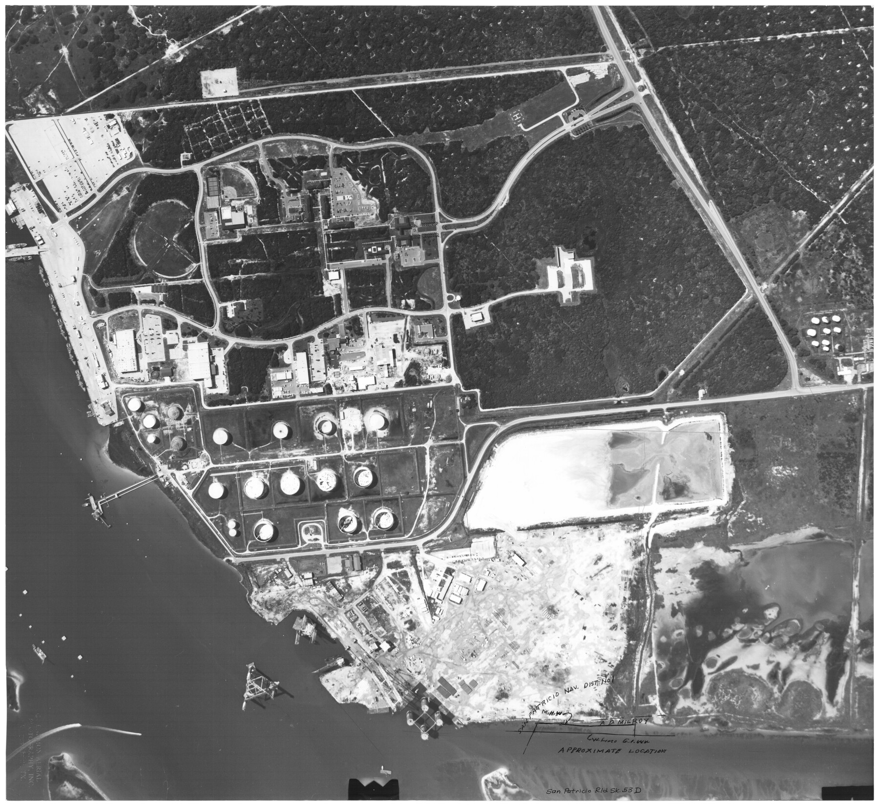
San Patricio County Rolled Sketch 53D
[Aerial photograph showing M.H.W. line of the A.D. Milroy survey adjacent to the Gulf Intracoastal Waterway]
-
Map/Doc
7739
-
Collection
General Map Collection
-
Counties
San Patricio
-
Subjects
Surveying Rolled Sketch
-
Height x Width
20.1 x 22.1 inches
51.1 x 56.1 cm
-
Medium
photograph
Part of: General Map Collection
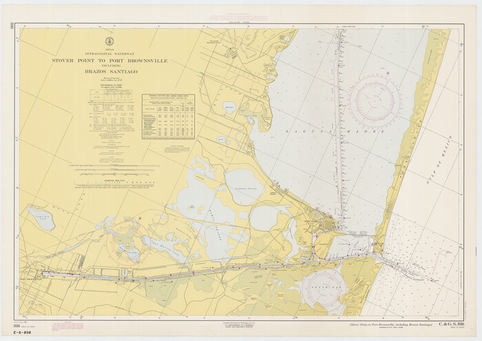
Texas Intracoastal Waterway - Stover Point to Port Brownsville including Brazos Santiago
Print $20.00
- Digital $50.00
Texas Intracoastal Waterway - Stover Point to Port Brownsville including Brazos Santiago
1965
Size 27.5 x 38.9 inches
Map/Doc 73521
Falls County Sketch File 23

Print $20.00
- Digital $50.00
Falls County Sketch File 23
1921
Size 24.8 x 36.3 inches
Map/Doc 11467
Aransas County Rolled Sketch 8

Print $20.00
- Digital $50.00
Aransas County Rolled Sketch 8
Size 41.0 x 43.5 inches
Map/Doc 8408
[Location Survey of the Southern Kansas Railway, Kiowa Extension from a point in Drake's Location, in Indian Territory 100 miles from south line of Kansas, continuing up Wolf Creek and South Canadian River to Cottonwood Creek in Hutchinson County]
![88839, [Location Survey of the Southern Kansas Railway, Kiowa Extension from a point in Drake's Location, in Indian Territory 100 miles from south line of Kansas, continuing up Wolf Creek and South Canadian River to Cottonwood Creek in Hutchinson County], General Map Collection](https://historictexasmaps.com/wmedia_w700/maps/88839.tif.jpg)
Print $20.00
- Digital $50.00
[Location Survey of the Southern Kansas Railway, Kiowa Extension from a point in Drake's Location, in Indian Territory 100 miles from south line of Kansas, continuing up Wolf Creek and South Canadian River to Cottonwood Creek in Hutchinson County]
1886
Size 38.9 x 36.0 inches
Map/Doc 88839
Flight Mission No. DAG-18K, Frame 68, Matagorda County

Print $20.00
- Digital $50.00
Flight Mission No. DAG-18K, Frame 68, Matagorda County
1952
Size 16.4 x 16.3 inches
Map/Doc 86361
Menard County Sketch File 15

Print $8.00
- Digital $50.00
Menard County Sketch File 15
1892
Size 12.9 x 8.3 inches
Map/Doc 31510

United States Bathymetric and Fishing Maps including Topographic/Bathymetric Maps

Print $40.00
- Digital $50.00
United States Bathymetric and Fishing Maps including Topographic/Bathymetric Maps
1992
Size 21.5 x 54.9 inches
Map/Doc 76128
Map of the Texas & Pacific Ry. Reserve West of the Pecos River

Print $40.00
- Digital $50.00
Map of the Texas & Pacific Ry. Reserve West of the Pecos River
1879
Size 55.4 x 118.1 inches
Map/Doc 96439
Harrison County Working Sketch 16

Print $20.00
- Digital $50.00
Harrison County Working Sketch 16
1966
Size 29.2 x 33.0 inches
Map/Doc 66036
Map of the County of Nueces

Print $20.00
- Digital $50.00
Map of the County of Nueces
1859
Size 39.3 x 39.6 inches
Map/Doc 78391
Wilson County Sketch File 8

Print $8.00
- Digital $50.00
Wilson County Sketch File 8
1879
Size 10.4 x 8.2 inches
Map/Doc 40413
You may also like
Caddo-Breckenridge Districts, Stephens County, Texas Ranger-Eastland-Cisco Districts Eastland County, Texas

Print $20.00
- Digital $50.00
Caddo-Breckenridge Districts, Stephens County, Texas Ranger-Eastland-Cisco Districts Eastland County, Texas
1919
Size 34.9 x 44.5 inches
Map/Doc 89808
Tyler County Working Sketch 7

Print $20.00
- Digital $50.00
Tyler County Working Sketch 7
1937
Size 18.8 x 24.1 inches
Map/Doc 69477
Runnels County Rolled Sketch 18

Print $20.00
- Digital $50.00
Runnels County Rolled Sketch 18
Size 23.1 x 25.3 inches
Map/Doc 7513
Val Verde County Sketch File 38

Print $44.00
- Digital $50.00
Val Verde County Sketch File 38
1938
Size 17.6 x 17.2 inches
Map/Doc 12579
Shackelford County Sketch File 5

Print $4.00
- Digital $50.00
Shackelford County Sketch File 5
1885
Size 12.3 x 7.6 inches
Map/Doc 36578
Wharton County Sketch File 25

Print $4.00
- Digital $50.00
Wharton County Sketch File 25
1978
Size 11.1 x 8.7 inches
Map/Doc 39988
Flight Mission No. DIX-5P, Frame 116, Aransas County

Print $20.00
- Digital $50.00
Flight Mission No. DIX-5P, Frame 116, Aransas County
1956
Size 17.8 x 18.1 inches
Map/Doc 83795
Wheeler County Working Sketch 1

Print $40.00
- Digital $50.00
Wheeler County Working Sketch 1
1940
Size 52.5 x 28.7 inches
Map/Doc 72490
Kaufman County

Print $20.00
- Digital $50.00
Kaufman County
1942
Size 46.6 x 38.2 inches
Map/Doc 1871
University Land, Winkler-Andrews-Gaines-Dawson-Martin Counties

Print $40.00
- Digital $50.00
University Land, Winkler-Andrews-Gaines-Dawson-Martin Counties
Size 42.8 x 53.2 inches
Map/Doc 62931
Denton County Working Sketch 7

Print $20.00
- Digital $50.00
Denton County Working Sketch 7
1958
Size 26.0 x 28.8 inches
Map/Doc 68612
Flight Mission No. CUG-1P, Frame 72, Kleberg County

Print $20.00
- Digital $50.00
Flight Mission No. CUG-1P, Frame 72, Kleberg County
1956
Size 18.6 x 22.1 inches
Map/Doc 86137