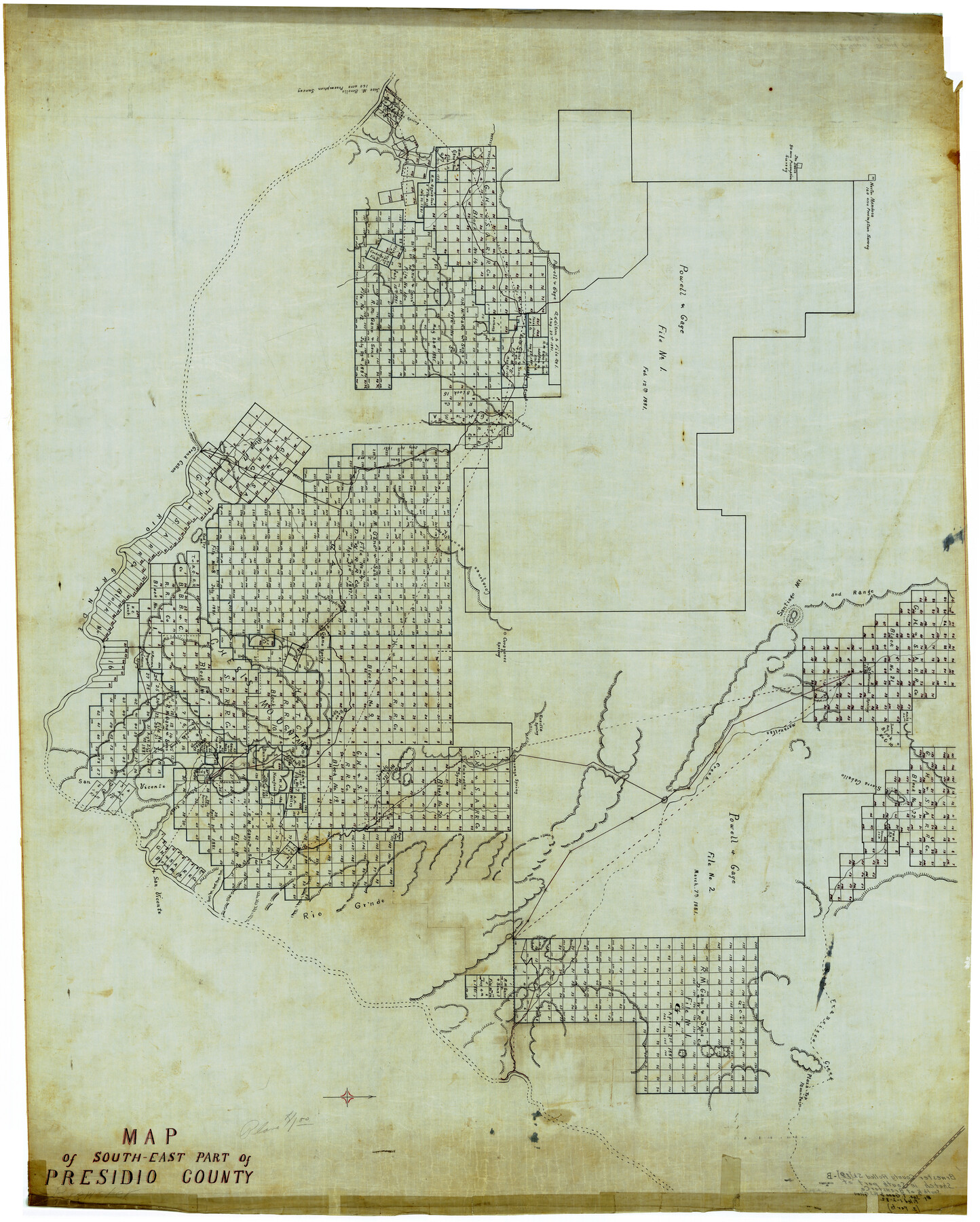
Brewster County Rolled Sketch 19B
Map of South-east part of Presidio County showing the locations made by R.M. Gano & Sons, together with connecting and adjoining surveys
-
Map/Doc
8472
-
Collection
General Map Collection
-
Object Dates
7/1881 (Creation Date)
1/2/1882 (File Date)
-
People and Organizations
E.G. Gleim (Surveyor/Engineer)
Jno. T. Gano (Surveyor/Engineer)
Jefferson Haskell (Chainman/Field Personnel)
Leslie Gadd (Chainman/Field Personnel)
Edward Kennedy (Chainman/Field Personnel)
-
Counties
Brewster
-
Subjects
Surveying Rolled Sketch
-
Height x Width
48.5 x 39.4 inches
123.2 x 100.1 cm
-
Medium
linen, manuscript
-
Scale
1" = 4000 varas
-
Comments
See Brewster County Rolled Sketch 19A (8471) for bottom half of this sketch.
Related maps
Brewster County Rolled Sketch 19A

Print $20.00
- Digital $50.00
Brewster County Rolled Sketch 19A
1881
Size 31.5 x 38.6 inches
Map/Doc 8471
Part of: General Map Collection
Grayson County Rolled Sketch 4

Print $20.00
- Digital $50.00
Grayson County Rolled Sketch 4
1953
Size 26.0 x 27.7 inches
Map/Doc 6031
Fayette County Working Sketch 7

Print $20.00
- Digital $50.00
Fayette County Working Sketch 7
1981
Size 24.1 x 15.6 inches
Map/Doc 69171
Map of The Surveyed Part of Peters Colony Texas

Print $40.00
- Digital $50.00
Map of The Surveyed Part of Peters Colony Texas
1852
Size 54.6 x 34.6 inches
Map/Doc 4654
[Cotton Belt, St. Louis Southwestern Railway of Texas, Alignment through Smith County]
![64381, [Cotton Belt, St. Louis Southwestern Railway of Texas, Alignment through Smith County], General Map Collection](https://historictexasmaps.com/wmedia_w700/maps/64381.tif.jpg)
Print $20.00
- Digital $50.00
[Cotton Belt, St. Louis Southwestern Railway of Texas, Alignment through Smith County]
1903
Size 21.3 x 29.4 inches
Map/Doc 64381
Bandera County Sketch File 35

Print $2.00
- Digital $50.00
Bandera County Sketch File 35
Size 11.2 x 8.7 inches
Map/Doc 14033
[Sketch for Mineral Application 24072, San Jacinto River]
![65609, [Sketch for Mineral Application 24072, San Jacinto River], General Map Collection](https://historictexasmaps.com/wmedia_w700/maps/65609.tif.jpg)
Print $20.00
- Digital $50.00
[Sketch for Mineral Application 24072, San Jacinto River]
1929
Size 8.4 x 13.9 inches
Map/Doc 65609
Edwards County Working Sketch 82

Print $20.00
- Digital $50.00
Edwards County Working Sketch 82
1964
Size 31.0 x 35.1 inches
Map/Doc 68958
Franklin County Sketch File 6

Print $4.00
- Digital $50.00
Franklin County Sketch File 6
1853
Size 9.6 x 7.4 inches
Map/Doc 23018
Brewster County Rolled Sketch 78

Print $20.00
- Digital $50.00
Brewster County Rolled Sketch 78
1945
Size 19.8 x 28.0 inches
Map/Doc 5243
Childress County Rolled Sketch 9C

Print $20.00
- Digital $50.00
Childress County Rolled Sketch 9C
Size 13.8 x 17.9 inches
Map/Doc 5449
Flight Mission No. BRA-6M, Frame 88, Jefferson County

Print $20.00
- Digital $50.00
Flight Mission No. BRA-6M, Frame 88, Jefferson County
1953
Size 18.4 x 22.4 inches
Map/Doc 85431
Hartley County Sketch File A

Print $4.00
- Digital $50.00
Hartley County Sketch File A
Size 8.9 x 10.4 inches
Map/Doc 26081
You may also like
Schleicher County Sketch File 6

Print $4.00
- Digital $50.00
Schleicher County Sketch File 6
Size 8.1 x 8.5 inches
Map/Doc 36472
Maps of Gulf Intracoastal Waterway, Texas - Sabine River to the Rio Grande and connecting waterways including ship channels

Print $20.00
- Digital $50.00
Maps of Gulf Intracoastal Waterway, Texas - Sabine River to the Rio Grande and connecting waterways including ship channels
1966
Size 14.6 x 22.3 inches
Map/Doc 61956
[South Center of County near surveys 1144 and 1143]
![90502, [South Center of County near surveys 1144 and 1143], Twichell Survey Records](https://historictexasmaps.com/wmedia_w700/maps/90502-1.tif.jpg)
Print $2.00
- Digital $50.00
[South Center of County near surveys 1144 and 1143]
Size 6.6 x 16.1 inches
Map/Doc 90502
Jefferson County Rolled Sketch 57

Print $20.00
- Digital $50.00
Jefferson County Rolled Sketch 57
1883
Size 18.6 x 25.9 inches
Map/Doc 6409

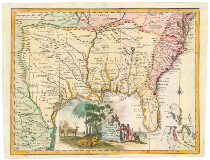
Carta Geografica Della Florida Nell America Settentrionale
Print $20.00
- Digital $50.00
Carta Geografica Della Florida Nell America Settentrionale
1740
Size 14.1 x 18.5 inches
Map/Doc 89222
K&E Leroy Lettering Set - 3240

K&E Leroy Lettering Set - 3240
1944
Size 1.8 x 15.5 inches
Map/Doc 97314
Block A; Melvin, Blum and Blum, Bailey County, Texas

Print $20.00
- Digital $50.00
Block A; Melvin, Blum and Blum, Bailey County, Texas
Size 23.8 x 19.5 inches
Map/Doc 92539
Gillespie County

Print $20.00
- Digital $50.00
Gillespie County
1877
Size 20.1 x 24.5 inches
Map/Doc 3583
Dickens County Sketch File F1

Print $28.00
- Digital $50.00
Dickens County Sketch File F1
Size 11.4 x 8.7 inches
Map/Doc 20849
Taylor County Working Sketch 14

Print $20.00
- Digital $50.00
Taylor County Working Sketch 14
1959
Size 26.8 x 21.4 inches
Map/Doc 69624
Bandera County Sketch File 8

Print $6.00
- Digital $50.00
Bandera County Sketch File 8
1878
Size 13.0 x 11.8 inches
Map/Doc 14007