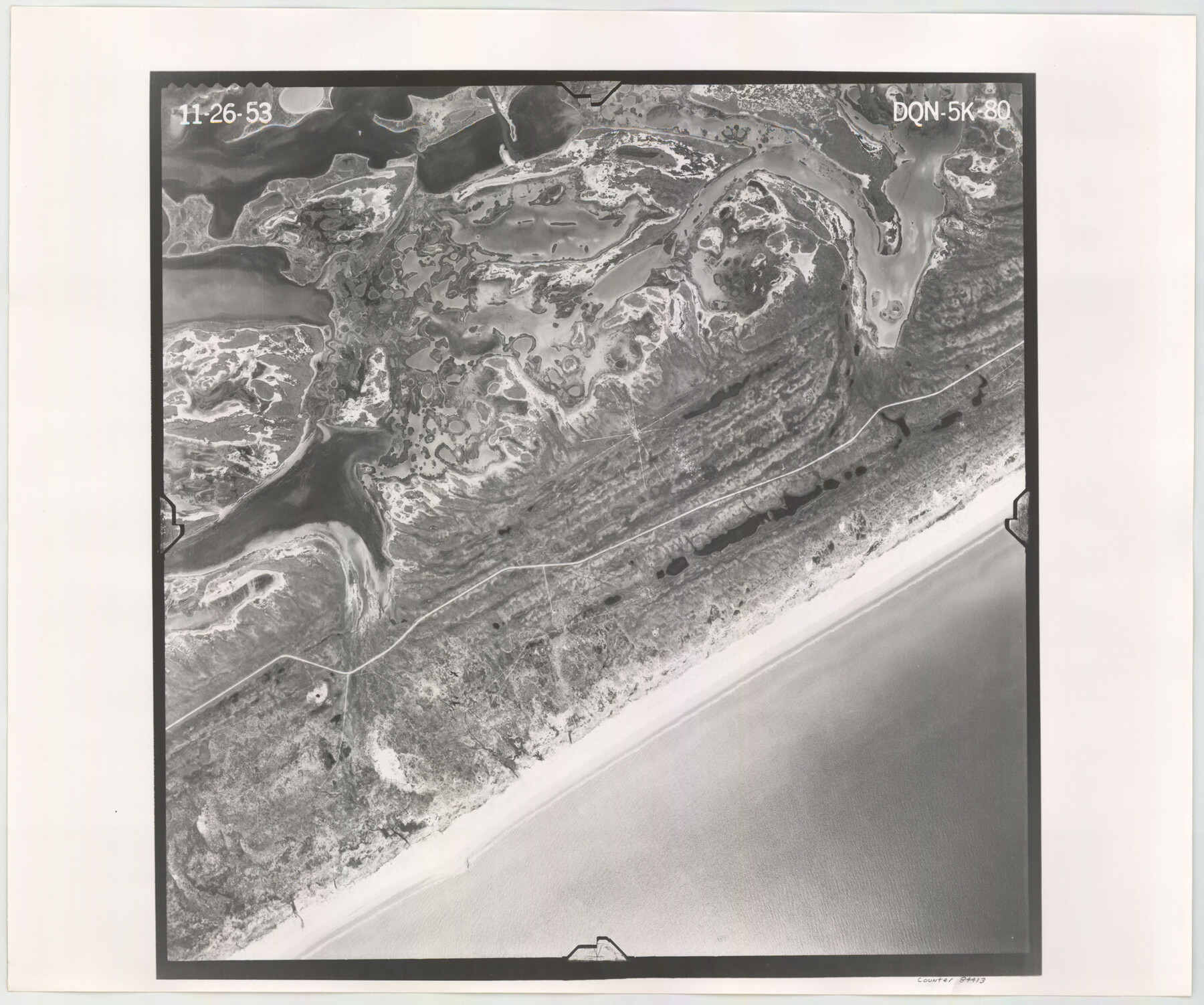
Flight Mission No. DQN-5K, Frame 80, Calhoun County
DQN-5K-80
-
Map/Doc
84413
-
Collection
General Map Collection
-
Object Dates
1953/11/26 (Creation Date)
-
People and Organizations
U. S. Department of Agriculture (Publisher)
-
Counties
Calhoun
-
Subjects
Aerial Photograph
-
Height x Width
18.5 x 22.1 inches
47.0 x 56.1 cm
-
Comments
Flown by Aero Exploration Company of Tulsa, Oklahoma.
Part of: General Map Collection
Live Oak County Working Sketch 22

Print $40.00
- Digital $50.00
Live Oak County Working Sketch 22
1976
Size 63.1 x 31.9 inches
Map/Doc 70607
Coleman County Sketch File 32

Print $4.00
- Digital $50.00
Coleman County Sketch File 32
Size 12.8 x 8.4 inches
Map/Doc 18723
Flight Mission No. BQY-4M, Frame 55, Harris County

Print $20.00
- Digital $50.00
Flight Mission No. BQY-4M, Frame 55, Harris County
1953
Size 18.5 x 22.3 inches
Map/Doc 85264
Karnes County Boundary File 1

Print $14.00
- Digital $50.00
Karnes County Boundary File 1
Size 8.5 x 7.0 inches
Map/Doc 55679
Wichita County Rolled Sketch 13

Print $20.00
- Digital $50.00
Wichita County Rolled Sketch 13
Size 25.7 x 16.6 inches
Map/Doc 8250
Hardin County Working Sketch 26

Print $20.00
- Digital $50.00
Hardin County Working Sketch 26
1954
Size 19.5 x 23.8 inches
Map/Doc 63424
Intracoastal Waterway in Texas - Corpus Christi to Point Isabel including Arroyo Colorado to Mo. Pac. R.R. Bridge Near Harlingen

Print $20.00
- Digital $50.00
Intracoastal Waterway in Texas - Corpus Christi to Point Isabel including Arroyo Colorado to Mo. Pac. R.R. Bridge Near Harlingen
1933
Size 28.1 x 41.2 inches
Map/Doc 61845
Flight Mission No. CRC-5R, Frame 22, Chambers County

Print $20.00
- Digital $50.00
Flight Mission No. CRC-5R, Frame 22, Chambers County
1956
Size 18.7 x 22.6 inches
Map/Doc 84944
Culberson County Rolled Sketch 45

Print $20.00
- Digital $50.00
Culberson County Rolled Sketch 45
1954
Size 19.1 x 23.4 inches
Map/Doc 5667
Ownership Map of McCulloch County, Texas

Print $20.00
- Digital $50.00
Ownership Map of McCulloch County, Texas
1951
Size 40.5 x 32.5 inches
Map/Doc 3138
Johnson County Sketch File 11

Print $8.00
- Digital $50.00
Johnson County Sketch File 11
1880
Size 8.0 x 6.8 inches
Map/Doc 28447
You may also like
Hardeman County Working Sketch 2

Print $20.00
- Digital $50.00
Hardeman County Working Sketch 2
1900
Size 19.1 x 19.4 inches
Map/Doc 63383
Photo Index of Texas Coast - Sheet 1 of 6

Print $20.00
- Digital $50.00
Photo Index of Texas Coast - Sheet 1 of 6
1954
Size 20.0 x 24.0 inches
Map/Doc 83438
Maps of Gulf Intracoastal Waterway, Texas - Sabine River to the Rio Grande and connecting waterways including ship channels

Print $20.00
- Digital $50.00
Maps of Gulf Intracoastal Waterway, Texas - Sabine River to the Rio Grande and connecting waterways including ship channels
1966
Size 15.7 x 22.0 inches
Map/Doc 61987
![90595, [Block K7], Twichell Survey Records](https://historictexasmaps.com/wmedia_w700/maps/90595-1.tif.jpg)
Hamilton County Working Sketch 1

Print $20.00
- Digital $50.00
Hamilton County Working Sketch 1
1914
Size 17.7 x 17.8 inches
Map/Doc 63339
Collin County Sketch File 15

Print $4.00
- Digital $50.00
Collin County Sketch File 15
1873
Size 10.0 x 8.0 inches
Map/Doc 18880
Crockett County Rolled Sketch JAS

Print $40.00
- Digital $50.00
Crockett County Rolled Sketch JAS
1938
Size 52.9 x 42.7 inches
Map/Doc 8699
Titus County Sketch File 13

Print $6.00
- Digital $50.00
Titus County Sketch File 13
1929
Size 9.0 x 8.8 inches
Map/Doc 38154
South Part Brewster Co.

Print $40.00
- Digital $50.00
South Part Brewster Co.
1910
Size 32.0 x 49.7 inches
Map/Doc 66728
Terrell County Rolled Sketch 59

Print $20.00
- Digital $50.00
Terrell County Rolled Sketch 59
Size 32.5 x 28.2 inches
Map/Doc 7975
Blanco County Working Sketch 29

Print $40.00
- Digital $50.00
Blanco County Working Sketch 29
1969
Size 52.4 x 33.4 inches
Map/Doc 67389
Val Verde County Sketch File 20

Print $20.00
- Digital $50.00
Val Verde County Sketch File 20
1881
Size 26.5 x 37.2 inches
Map/Doc 12569