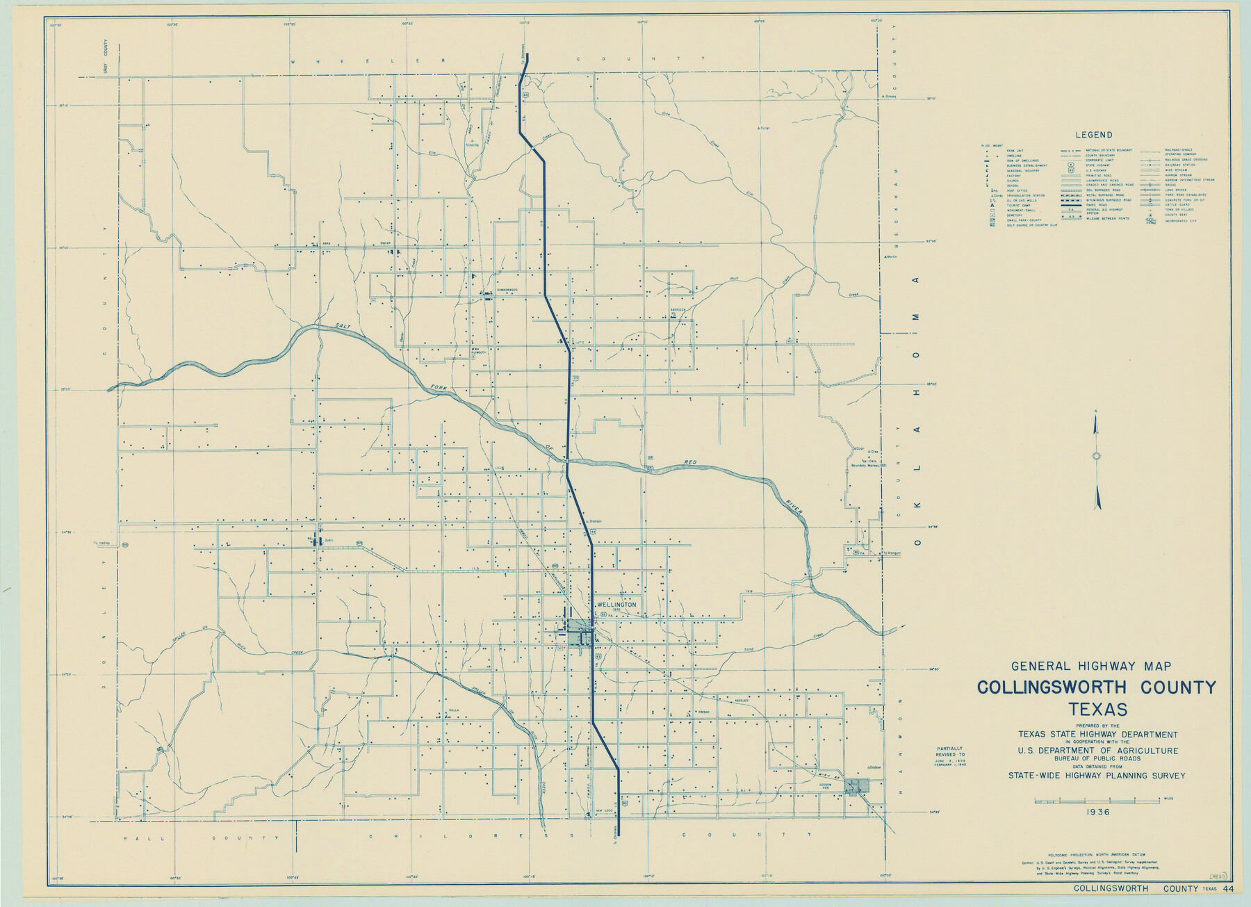
General Highway Map, Collingsworth County, Texas
-
Map/Doc
79053
-
Collection
Texas State Library and Archives
-
Object Dates
1940 (Creation Date)
-
People and Organizations
Texas State Highway Department (Publisher)
-
Counties
Collingsworth
-
Subjects
County
-
Height x Width
18.3 x 25.2 inches
46.5 x 64.0 cm
-
Comments
Prints available courtesy of the Texas State Library and Archives.
More info can be found here: TSLAC Map 04825
Part of: Texas State Library and Archives
General Highway Map, Kleberg County, Texas

Print $20.00
General Highway Map, Kleberg County, Texas
1961
Size 24.6 x 18.3 inches
Map/Doc 79559
General Highway Map. Detail of Cities and Towns in Kinney County, Uvalde County [Uvalde and vicinity]
![79557, General Highway Map. Detail of Cities and Towns in Kinney County, Uvalde County [Uvalde and vicinity], Texas State Library and Archives](https://historictexasmaps.com/wmedia_w700/maps/79557.tif.jpg)
Print $20.00
General Highway Map. Detail of Cities and Towns in Kinney County, Uvalde County [Uvalde and vicinity]
1961
Size 18.2 x 24.6 inches
Map/Doc 79557
General Highway Map, Medina County, Texas

Print $20.00
General Highway Map, Medina County, Texas
1940
Size 18.3 x 24.5 inches
Map/Doc 79194
General Highway Map, Medina County, Texas

Print $20.00
General Highway Map, Medina County, Texas
1961
Size 18.1 x 24.5 inches
Map/Doc 79593
General Highway Map. Detail of Cities and Towns in Travis County, Texas [Austin]
![79262, General Highway Map. Detail of Cities and Towns in Travis County, Texas [Austin], Texas State Library and Archives](https://historictexasmaps.com/wmedia_w700/maps/79262-1.tif.jpg)
Print $20.00
General Highway Map. Detail of Cities and Towns in Travis County, Texas [Austin]
1940
Size 18.2 x 25.0 inches
Map/Doc 79262
Sectional Map of Texas Traversed by the Missouri, Kansas, and Texas Railway Showing the crops adapted to each section, with the elevation and annual rainfall.

Print $20.00
Sectional Map of Texas Traversed by the Missouri, Kansas, and Texas Railway Showing the crops adapted to each section, with the elevation and annual rainfall.
1909
Size 21.8 x 22.9 inches
Map/Doc 76265
General Highway Map, Jeff Davis County, Texas

Print $20.00
General Highway Map, Jeff Davis County, Texas
1940
Size 18.6 x 24.8 inches
Map/Doc 79143
Map of the Country Upon the Brazos and Big Wichita Rivers Embracing the Lands appropriated by the State of Texas for the Use of the Indians

Print $20.00
Map of the Country Upon the Brazos and Big Wichita Rivers Embracing the Lands appropriated by the State of Texas for the Use of the Indians
1854
Size 28.8 x 32.3 inches
Map/Doc 76284
General Highway Map, Wood County, Texas

Print $20.00
General Highway Map, Wood County, Texas
1961
Size 18.1 x 24.8 inches
Map/Doc 79718
General Highway Map. Detail of Cities and Towns in Grayson County, Texas [Denison and Sherman]
![79486, General Highway Map. Detail of Cities and Towns in Grayson County, Texas [Denison and Sherman], Texas State Library and Archives](https://historictexasmaps.com/wmedia_w700/maps/79486.tif.jpg)
Print $20.00
General Highway Map. Detail of Cities and Towns in Grayson County, Texas [Denison and Sherman]
1961
Size 18.1 x 24.6 inches
Map/Doc 79486
Map of Central Texas Oil Fields

Print $20.00
Map of Central Texas Oil Fields
1918
Size 27.1 x 21.5 inches
Map/Doc 76295
General Highway Map, Dallas County, Rockwall County, Texas

Print $20.00
General Highway Map, Dallas County, Rockwall County, Texas
1936
Size 18.7 x 25.2 inches
Map/Doc 79066
You may also like
Geological Map of Texas

Print $20.00
- Digital $50.00
Geological Map of Texas
1919
Size 34.9 x 36.8 inches
Map/Doc 94091
Crockett County Working Sketch 45

Print $20.00
- Digital $50.00
Crockett County Working Sketch 45
1933
Size 33.7 x 26.8 inches
Map/Doc 68378
Coke County Boundary File 4

Print $44.00
- Digital $50.00
Coke County Boundary File 4
Size 14.3 x 8.7 inches
Map/Doc 51593
Flight Mission No. CRE-2R, Frame 80, Jackson County

Print $20.00
- Digital $50.00
Flight Mission No. CRE-2R, Frame 80, Jackson County
1956
Size 18.7 x 22.3 inches
Map/Doc 85352
Nueces County Rolled Sketch 126 A-G

Print $22.00
- Digital $50.00
Nueces County Rolled Sketch 126 A-G
1998
Size 11.3 x 8.8 inches
Map/Doc 8962
Leon County Sketch File 5

Print $4.00
- Digital $50.00
Leon County Sketch File 5
Size 8.0 x 7.8 inches
Map/Doc 29715
Mills County Sketch File 22

Print $4.00
- Digital $50.00
Mills County Sketch File 22
1882
Size 9.8 x 8.0 inches
Map/Doc 31670
General Highway Map, Scurry County, Texas

Print $20.00
General Highway Map, Scurry County, Texas
1961
Size 18.1 x 24.8 inches
Map/Doc 79650
A Topographical Map of the City of Austin

Print $20.00
- Digital $50.00
A Topographical Map of the City of Austin
1872
Size 21.0 x 14.7 inches
Map/Doc 4821
Kimble County Working Sketch 86

Print $20.00
- Digital $50.00
Kimble County Working Sketch 86
1973
Size 39.3 x 25.6 inches
Map/Doc 70154
[H. & T. C. Block 47, Sections 58-66 and part of Block 3]
![91791, [H. & T. C. Block 47, Sections 58-66 and part of Block 3], Twichell Survey Records](https://historictexasmaps.com/wmedia_w700/maps/91791-1.tif.jpg)
Print $20.00
- Digital $50.00
[H. & T. C. Block 47, Sections 58-66 and part of Block 3]
Size 24.1 x 12.7 inches
Map/Doc 91791
Current Miscellaneous File 31

Print $8.00
- Digital $50.00
Current Miscellaneous File 31
1916
Size 11.2 x 8.7 inches
Map/Doc 73929