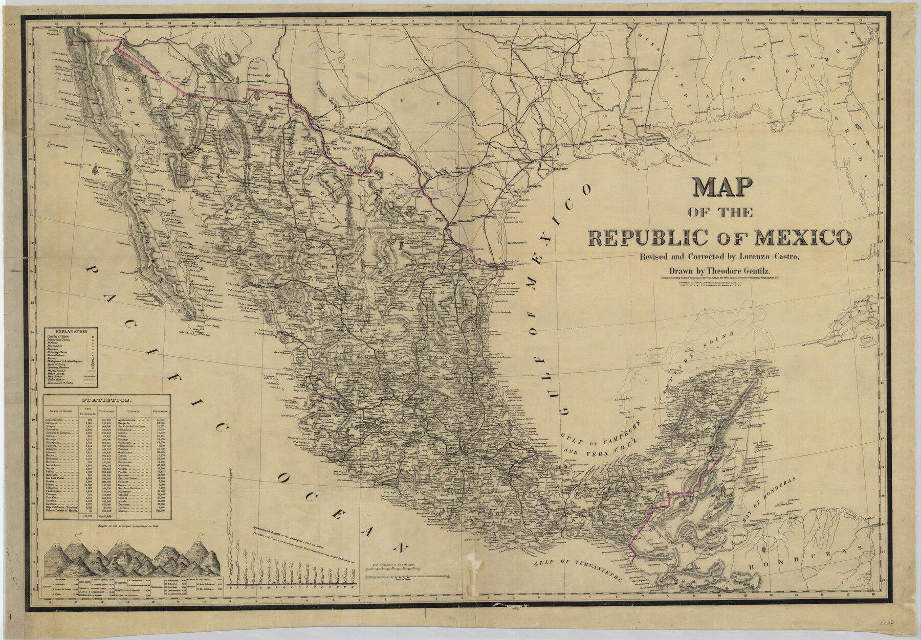
Map of the Republic of Mexico
-
Map/Doc
76220
-
Collection
Texas State Library and Archives
-
Object Dates
1882 (Creation Date)
-
People and Organizations
Theodore Gentilz (Draftsman)
-
Subjects
Mexico
-
Height x Width
33.0 x 47.4 inches
83.8 x 120.4 cm
-
Comments
Prints available courtesy of the Texas State Library and Archives.
More info can be found here: TSLAC Map 01027
Part of: Texas State Library and Archives
General Highway Map. Detail of Cities and Towns in Dallas County, Texas [Dallas and vicinity]
![79432, General Highway Map. Detail of Cities and Towns in Dallas County, Texas [Dallas and vicinity], Texas State Library and Archives](https://historictexasmaps.com/wmedia_w700/maps/79432.tif.jpg)
Print $20.00
General Highway Map. Detail of Cities and Towns in Dallas County, Texas [Dallas and vicinity]
1961
Size 18.1 x 24.7 inches
Map/Doc 79432
General Highway Map, Victoria County, Texas

Print $20.00
General Highway Map, Victoria County, Texas
1961
Size 25.0 x 18.3 inches
Map/Doc 79697
The Continent and Islands of the West Indies

Print $20.00
The Continent and Islands of the West Indies
1804
Size 22.8 x 26.0 inches
Map/Doc 79318
Map of Texas, compiled from surveys on record in the General Land Office of the Republic

Print $20.00
Map of Texas, compiled from surveys on record in the General Land Office of the Republic
1847
Size 32.2 x 25.0 inches
Map/Doc 79325
General Highway Map. Detail of Cities and Towns in Bexar County, Texas [San Antonio and vicinity]
![79019, General Highway Map. Detail of Cities and Towns in Bexar County, Texas [San Antonio and vicinity], Texas State Library and Archives](https://historictexasmaps.com/wmedia_w700/maps/79019.tif.jpg)
Print $20.00
General Highway Map. Detail of Cities and Towns in Bexar County, Texas [San Antonio and vicinity]
1940
Size 18.6 x 25.0 inches
Map/Doc 79019
General Highway Map, Gregg County, Texas

Print $20.00
General Highway Map, Gregg County, Texas
1961
Size 18.1 x 24.6 inches
Map/Doc 79489
General Highway Map, Medina County, Texas

Print $20.00
General Highway Map, Medina County, Texas
1961
Size 18.1 x 24.5 inches
Map/Doc 79593
General Highway Map. Detail of Cities and Towns in Kinney County, Uvalde County [Uvalde and vicinity]
![79557, General Highway Map. Detail of Cities and Towns in Kinney County, Uvalde County [Uvalde and vicinity], Texas State Library and Archives](https://historictexasmaps.com/wmedia_w700/maps/79557.tif.jpg)
Print $20.00
General Highway Map. Detail of Cities and Towns in Kinney County, Uvalde County [Uvalde and vicinity]
1961
Size 18.2 x 24.6 inches
Map/Doc 79557
The City of Austin and Suburbs

Print $20.00
The City of Austin and Suburbs
1919
Size 24.1 x 19.1 inches
Map/Doc 76203
Pocket Map of the State of Texas reduced from their original map of the State and drawn by Chas. W. Pressler and A. B. Langermann

Print $20.00
Pocket Map of the State of Texas reduced from their original map of the State and drawn by Chas. W. Pressler and A. B. Langermann
1879
Size 24.4 x 26.3 inches
Map/Doc 76208
Map of Texas and Adjacent Regions in the Eighteenth Century

Print $20.00
Map of Texas and Adjacent Regions in the Eighteenth Century
1915
Size 19.3 x 23.3 inches
Map/Doc 79743
General Highway Map. Detail of Cities and Towns in El Paso County, Texas [El Paso and vicinity]
![79085, General Highway Map. Detail of Cities and Towns in El Paso County, Texas [El Paso and vicinity], Texas State Library and Archives](https://historictexasmaps.com/wmedia_w700/maps/79085.tif.jpg)
Print $20.00
General Highway Map. Detail of Cities and Towns in El Paso County, Texas [El Paso and vicinity]
1940
Size 24.7 x 18.3 inches
Map/Doc 79085
You may also like
Brazos River, Washington Sheet

Print $6.00
- Digital $50.00
Brazos River, Washington Sheet
1936
Size 30.4 x 24.7 inches
Map/Doc 65277
Brazoria County Sketch File 55

Print $80.00
- Digital $50.00
Brazoria County Sketch File 55
1899
Size 14.9 x 55.0 inches
Map/Doc 10327
Childress County

Print $20.00
- Digital $50.00
Childress County
1921
Size 44.1 x 32.2 inches
Map/Doc 4746
Culberson County Sketch File 8

Print $40.00
- Digital $50.00
Culberson County Sketch File 8
1904
Size 13.2 x 14.6 inches
Map/Doc 20142
Map of Clay County

Print $20.00
- Digital $50.00
Map of Clay County
1883
Size 26.0 x 23.3 inches
Map/Doc 3396
Working Sketch of surveys in Mason, Kimble & Menard Counties

Print $20.00
- Digital $50.00
Working Sketch of surveys in Mason, Kimble & Menard Counties
1900
Size 32.1 x 42.4 inches
Map/Doc 75805
New Commercial Map of Texas

Print $20.00
New Commercial Map of Texas
1900
Size 28.1 x 34.0 inches
Map/Doc 76199
Flight Mission No. DCL-6C, Frame 3, Kenedy County

Print $20.00
- Digital $50.00
Flight Mission No. DCL-6C, Frame 3, Kenedy County
1943
Size 18.8 x 22.5 inches
Map/Doc 85863
Mrs. W. H. Bledsoe Farm NE 100.2 Acres of Section 37, Block AK

Print $2.00
- Digital $50.00
Mrs. W. H. Bledsoe Farm NE 100.2 Acres of Section 37, Block AK
Size 10.6 x 9.2 inches
Map/Doc 92283
Fractional Township No. 10 South Range No. 24 East of the Indian Meridian, Indian Territory

Print $20.00
- Digital $50.00
Fractional Township No. 10 South Range No. 24 East of the Indian Meridian, Indian Territory
1898
Size 19.1 x 24.2 inches
Map/Doc 75242
General Highway Map, San Patricio County, Texas

Print $20.00
General Highway Map, San Patricio County, Texas
1961
Size 18.1 x 24.5 inches
Map/Doc 79647
[Surveying Sketch of T. & N. O. R. R. Co., S. P. R. R. Co., E. T. R. R. Co., et al in Dallam, Hartley, Sherman & Moore Counties, Texas]
![75824, [Surveying Sketch of T. & N. O. R. R. Co., S. P. R. R. Co., E. T. R. R. Co., et al in Dallam, Hartley, Sherman & Moore Counties, Texas], Maddox Collection](https://historictexasmaps.com/wmedia_w700/maps/75824.tif.jpg)
Print $20.00
- Digital $50.00
[Surveying Sketch of T. & N. O. R. R. Co., S. P. R. R. Co., E. T. R. R. Co., et al in Dallam, Hartley, Sherman & Moore Counties, Texas]
Size 17.5 x 22.1 inches
Map/Doc 75824