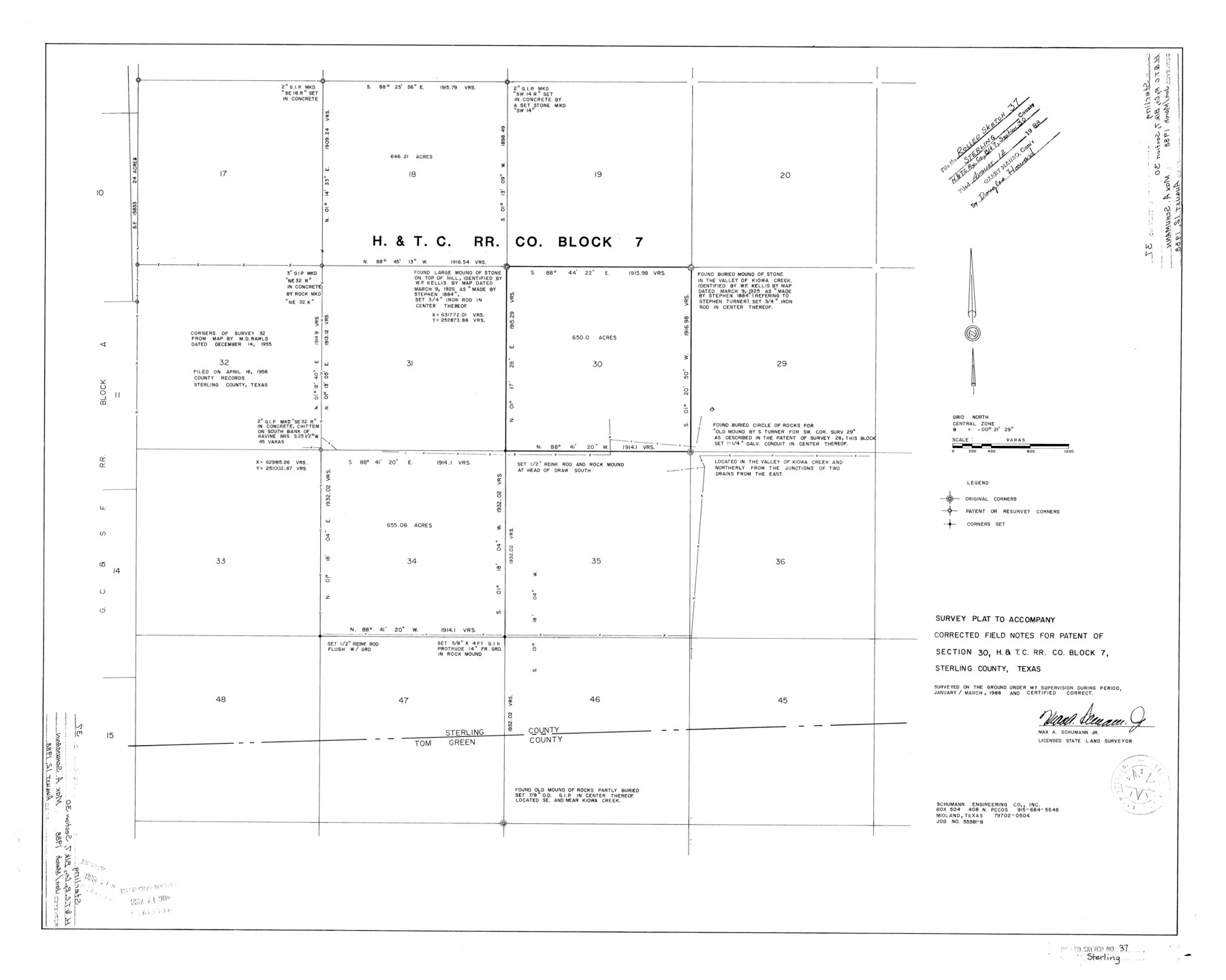
Sterling County Rolled Sketch 37
Survey plat to accompany corrected field notes for patent of section 30, H. & T. C. R.R. Co. Block 7, Sterling County, Texas
-
Map/Doc
7861
-
Collection
General Map Collection
-
Object Dates
1988 (Survey Date)
1988/8/12 (File Date)
-
People and Organizations
Max A. Schumann, Jr. (Surveyor/Engineer)
-
Counties
Sterling
-
Subjects
Surveying Rolled Sketch
-
Height x Width
25.4 x 31.8 inches
64.5 x 80.8 cm
-
Medium
mylar, print
Part of: General Map Collection
Culberson County Working Sketch 13

Print $20.00
- Digital $50.00
Culberson County Working Sketch 13
1922
Size 25.7 x 21.3 inches
Map/Doc 68465
Travis County Rolled Sketch 25A

Print $20.00
- Digital $50.00
Travis County Rolled Sketch 25A
1942
Size 21.7 x 29.1 inches
Map/Doc 8027
Reagan County Rolled Sketch 32

Print $20.00
- Digital $50.00
Reagan County Rolled Sketch 32
Size 46.3 x 38.5 inches
Map/Doc 9827
Hardin County Sketch File 62

Print $20.00
- Digital $50.00
Hardin County Sketch File 62
Size 19.9 x 26.2 inches
Map/Doc 11637
[Sketch for Mineral Application 24072, San Jacinto River]
![65589, [Sketch for Mineral Application 24072, San Jacinto River], General Map Collection](https://historictexasmaps.com/wmedia_w700/maps/65589.tif.jpg)
Print $20.00
- Digital $50.00
[Sketch for Mineral Application 24072, San Jacinto River]
1929
Size 29.6 x 14.7 inches
Map/Doc 65589
Leon County Working Sketch 58

Print $20.00
- Digital $50.00
Leon County Working Sketch 58
1986
Size 27.7 x 43.3 inches
Map/Doc 70458
Sherman County Rolled Sketch 14

Print $20.00
- Digital $50.00
Sherman County Rolled Sketch 14
1975
Size 17.4 x 17.7 inches
Map/Doc 7795
Angelina County

Print $40.00
- Digital $50.00
Angelina County
1945
Size 38.9 x 49.3 inches
Map/Doc 77200
Stonewall County Sketch File 5

Print $40.00
- Digital $50.00
Stonewall County Sketch File 5
Size 14.9 x 14.4 inches
Map/Doc 37206
Jefferson County Sketch File 37

Print $20.00
- Digital $50.00
Jefferson County Sketch File 37
Size 22.3 x 32.4 inches
Map/Doc 11875
Maps of Gulf Intracoastal Waterway, Texas - Sabine River to the Rio Grande and connecting waterways including ship channels

Print $20.00
- Digital $50.00
Maps of Gulf Intracoastal Waterway, Texas - Sabine River to the Rio Grande and connecting waterways including ship channels
1966
Size 14.2 x 20.1 inches
Map/Doc 61990
[Sketch for Mineral Application 19560 - 19588 - San Bernard River]
![65661, [Sketch for Mineral Application 19560 - 19588 - San Bernard River], General Map Collection](https://historictexasmaps.com/wmedia_w700/maps/65661.tif.jpg)
Print $40.00
- Digital $50.00
[Sketch for Mineral Application 19560 - 19588 - San Bernard River]
Size 32.3 x 98.5 inches
Map/Doc 65661
You may also like
Maps of Gulf Intracoastal Waterway, Texas - Sabine River to the Rio Grande and connecting waterways including ship channels

Print $20.00
- Digital $50.00
Maps of Gulf Intracoastal Waterway, Texas - Sabine River to the Rio Grande and connecting waterways including ship channels
1966
Size 14.6 x 20.5 inches
Map/Doc 62000
St. Louis, Brownsville & Mexico Railway Location Map from Mile 20 to Mile 40

Print $40.00
- Digital $50.00
St. Louis, Brownsville & Mexico Railway Location Map from Mile 20 to Mile 40
1906
Size 19.3 x 67.5 inches
Map/Doc 64077
Navarro County

Print $40.00
- Digital $50.00
Navarro County
1924
Size 41.5 x 47.9 inches
Map/Doc 73249
[Sections 27 and 28, Block B-19]
![91857, [Sections 27 and 28, Block B-19], Twichell Survey Records](https://historictexasmaps.com/wmedia_w700/maps/91857-1.tif.jpg)
Print $2.00
- Digital $50.00
[Sections 27 and 28, Block B-19]
Size 14.6 x 9.1 inches
Map/Doc 91857
Morris County Sketch File 3

Print $2.00
- Digital $50.00
Morris County Sketch File 3
Size 12.0 x 5.0 inches
Map/Doc 31967
Ector County Boundary File 3

Print $18.00
- Digital $50.00
Ector County Boundary File 3
Size 9.0 x 4.4 inches
Map/Doc 52836
Bailey County Sketch File B

Print $40.00
- Digital $50.00
Bailey County Sketch File B
Size 14.5 x 20.4 inches
Map/Doc 10891
Leon County Rolled Sketch 25

Print $20.00
- Digital $50.00
Leon County Rolled Sketch 25
Size 47.3 x 36.2 inches
Map/Doc 9434
Map of Jasper and Newton Counties

Print $20.00
- Digital $50.00
Map of Jasper and Newton Counties
1862
Size 36.5 x 25.8 inches
Map/Doc 3714
Rusk County Sketch File 43

Print $20.00
Rusk County Sketch File 43
1951
Size 23.5 x 26.6 inches
Map/Doc 12278
University Land Field Notes for Block 52 in Crockett, Irion, and Schleicher Counties, Blocks 55 and 56 in Crockett and Schleicher Counties, Block 53 in Irion and Schleicher Counties, and Blocks 54 and 57 in Schleicher County

University Land Field Notes for Block 52 in Crockett, Irion, and Schleicher Counties, Blocks 55 and 56 in Crockett and Schleicher Counties, Block 53 in Irion and Schleicher Counties, and Blocks 54 and 57 in Schleicher County
Map/Doc 81719
Brazoria County State Real Property Sketch 2

Print $60.00
- Digital $50.00
Brazoria County State Real Property Sketch 2
2003
Size 31.0 x 42.9 inches
Map/Doc 83356