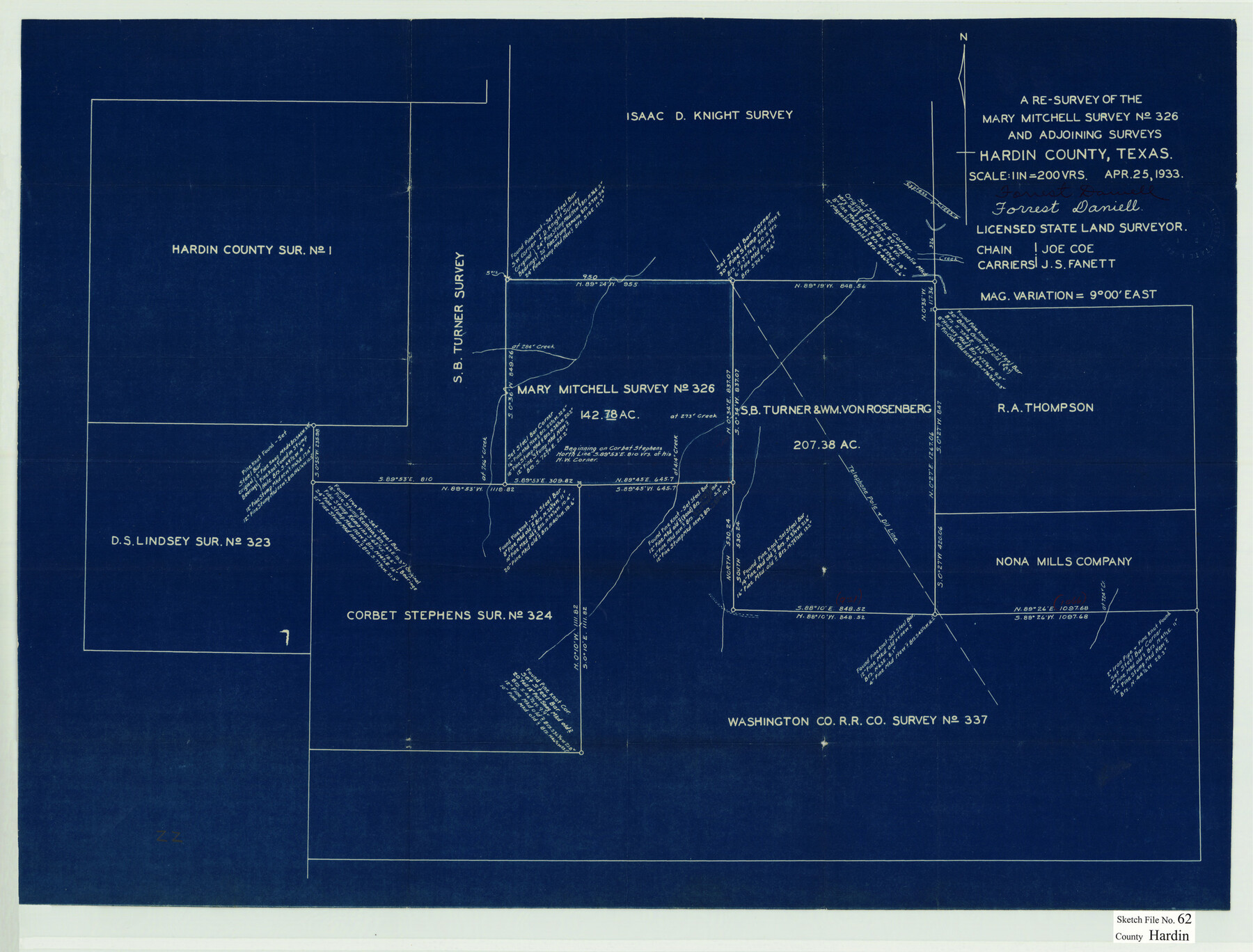
Hardin County Sketch File 62
A Re-Survey of the Mary Mitchell Survey No. 326 and Adjoining Surveys Hardin County, Texas
-
Map/Doc
11637
-
Collection
General Map Collection
-
Object Dates
1933/4/25 (Survey Date)
-
People and Organizations
Joe Coe (Chainman)
J.S. Fanett (Chainman)
-
Counties
Hardin
-
Subjects
Surveying Sketch File
-
Height x Width
19.9 x 26.2 inches
50.5 x 66.5 cm
-
Medium
blueprint/diazo
-
Scale
1:200
Part of: General Map Collection

Coast Chart No. 210 Aransas Pass and Corpus Christi Bay with the coast to latitude 27° 12' Texas

Print $20.00
- Digital $50.00
Coast Chart No. 210 Aransas Pass and Corpus Christi Bay with the coast to latitude 27° 12' Texas
1913
Size 27.5 x 18.3 inches
Map/Doc 72799
Hartley County Boundary File 3

Print $15.00
- Digital $50.00
Hartley County Boundary File 3
Size 6.7 x 16.5 inches
Map/Doc 54476
Dallam County Sketch File 6

Print $60.00
- Digital $50.00
Dallam County Sketch File 6
Size 12.4 x 17.0 inches
Map/Doc 20350
Packery Channel

Print $20.00
- Digital $50.00
Packery Channel
1954
Size 16.7 x 19.9 inches
Map/Doc 3002
Refugio County Sketch File 2

Print $6.00
- Digital $50.00
Refugio County Sketch File 2
1846
Size 12.6 x 7.7 inches
Map/Doc 35238

Gulf of Mexico

Print $20.00
- Digital $50.00
Gulf of Mexico
1905
Size 18.2 x 26.8 inches
Map/Doc 72651
Lee County Working Sketch 8

Print $20.00
- Digital $50.00
Lee County Working Sketch 8
1979
Size 27.8 x 37.1 inches
Map/Doc 70387
Sutton County Sketch File 9

Print $6.00
- Digital $50.00
Sutton County Sketch File 9
1893
Size 14.2 x 8.5 inches
Map/Doc 37367
Floyd County Sketch File 24

Print $6.00
- Digital $50.00
Floyd County Sketch File 24
1915
Size 9.0 x 14.5 inches
Map/Doc 22780
Trinity River, Levee Improvement Districts Widths of Floodways

Print $6.00
- Digital $50.00
Trinity River, Levee Improvement Districts Widths of Floodways
1920
Size 33.3 x 21.7 inches
Map/Doc 65251
You may also like
Kinney County Working Sketch 16

Print $20.00
- Digital $50.00
Kinney County Working Sketch 16
1946
Size 46.3 x 37.7 inches
Map/Doc 70198

Dawson County Sketch File 28

Print $20.00
- Digital $50.00
Dawson County Sketch File 28
1961
Size 46.0 x 15.3 inches
Map/Doc 10362
Texas-Oklahoma (Indian Territory) Gainesville Quadrangle

Print $20.00
- Digital $50.00
Texas-Oklahoma (Indian Territory) Gainesville Quadrangle
1902
Size 21.2 x 17.2 inches
Map/Doc 75101
Jasper County Rolled Sketch 4

Print $20.00
- Digital $50.00
Jasper County Rolled Sketch 4
1947
Size 40.0 x 31.1 inches
Map/Doc 6351

Colorado County Rolled Sketch 7

Print $20.00
- Digital $50.00
Colorado County Rolled Sketch 7
1997
Size 26.2 x 19.1 inches
Map/Doc 5534
Burnet County Sketch File 32

Print $4.00
- Digital $50.00
Burnet County Sketch File 32
1894
Size 8.0 x 9.5 inches
Map/Doc 16750
Maps of Gulf Intracoastal Waterway, Texas - Sabine River to the Rio Grande and connecting waterways including ship channels

Print $20.00
- Digital $50.00
Maps of Gulf Intracoastal Waterway, Texas - Sabine River to the Rio Grande and connecting waterways including ship channels
1966
Size 14.5 x 22.3 inches
Map/Doc 61921
Culberson County Rolled Sketch 59

Print $14.00
- Digital $50.00
Culberson County Rolled Sketch 59
Size 37.3 x 78.1 inches
Map/Doc 8760
General Highway Map, Collingsworth County, Texas

Print $20.00
General Highway Map, Collingsworth County, Texas
1940
Size 18.3 x 25.2 inches
Map/Doc 79053
[Sketch for Mineral Application 1112 - Colorado River, H. E. Chambers]
![65642, [Sketch for Mineral Application 1112 - Colorado River, H. E. Chambers], General Map Collection](https://historictexasmaps.com/wmedia_w700/maps/65642.tif.jpg)
Print $20.00
- Digital $50.00
[Sketch for Mineral Application 1112 - Colorado River, H. E. Chambers]
1918
Size 17.1 x 28.4 inches
Map/Doc 65642