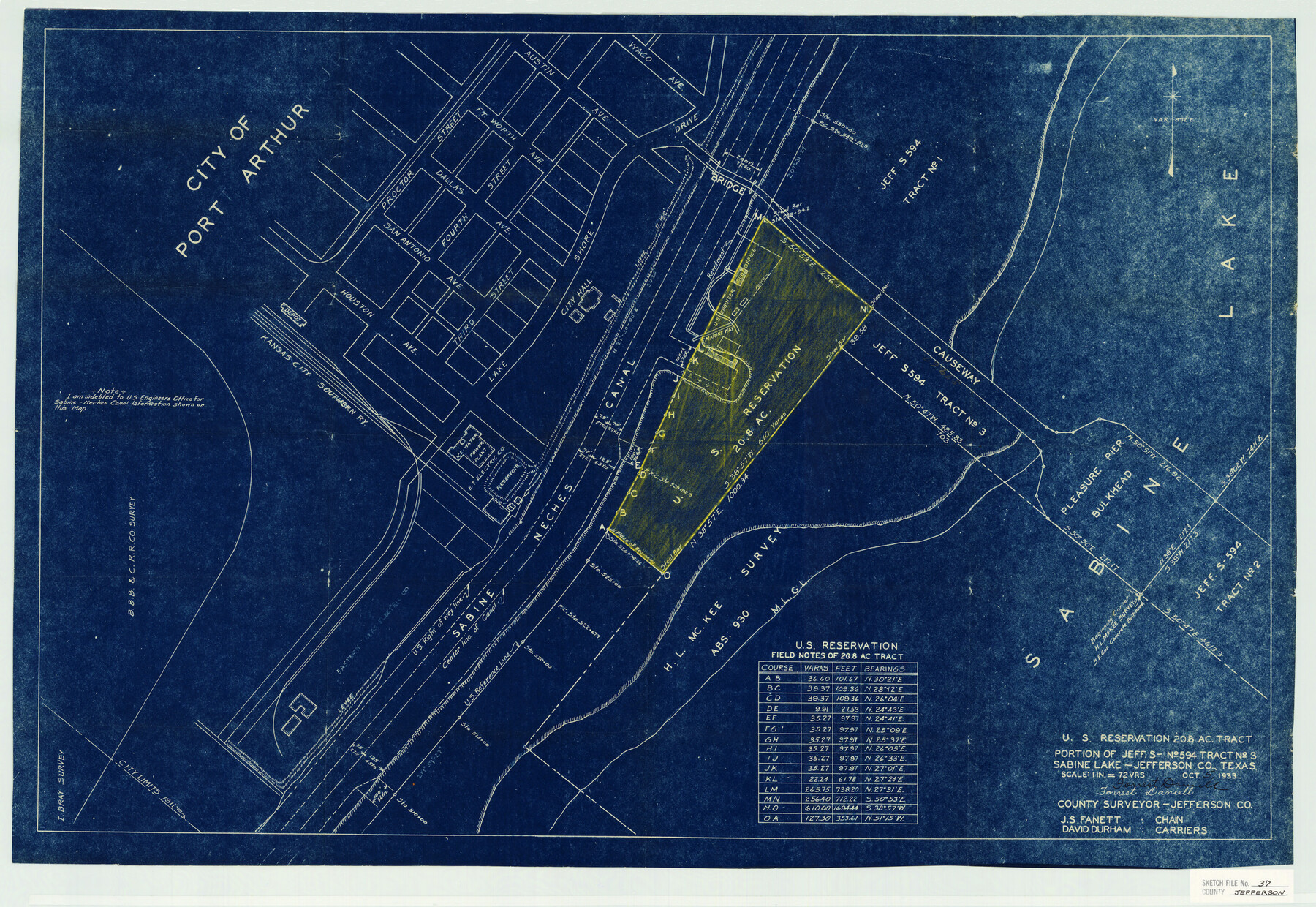
Jefferson County Sketch File 37
Waterfront sale to government (US)
-
Map/Doc
11875
-
Collection
General Map Collection
-
Object Dates
10/6/1933 (File Date)
10/5/1933 (Survey Date)
-
People and Organizations
Forrest Daniell (Surveyor/Engineer)
J.S. Fanett (Chainman)
David Durham (Chainman)
-
Counties
Jefferson
-
Subjects
Surveying Sketch File
-
Height x Width
22.3 x 32.4 inches
56.6 x 82.3 cm
-
Medium
blueprint/diazo
-
Scale
1:72
-
Features
Port Arthur
Proctor Street
Waco Avenue
Austin Avenue
Dallas Avenue
San Antonio Avenue
Houston Avenue
Fourth Street
Third Street
Causeway
Sabine Lake
Lake Shore Drive
KCS
Sabine Neches Canal
Part of: General Map Collection
Flight Mission No. BQR-13K, Frame 27, Brazoria County

Print $20.00
- Digital $50.00
Flight Mission No. BQR-13K, Frame 27, Brazoria County
1952
Size 18.7 x 22.5 inches
Map/Doc 84075
Geographical, Statistical, and Historical Map of the District of Columbia

Print $20.00
- Digital $50.00
Geographical, Statistical, and Historical Map of the District of Columbia
Size 18.0 x 22.4 inches
Map/Doc 97102

Lubbock County Sketch File 11

Print $22.00
- Digital $50.00
Lubbock County Sketch File 11
1914
Size 11.2 x 8.8 inches
Map/Doc 30434
Flight Mission No. BRE-1P, Frame 115, Nueces County

Print $20.00
- Digital $50.00
Flight Mission No. BRE-1P, Frame 115, Nueces County
1956
Size 18.4 x 22.2 inches
Map/Doc 86681
Jack County Working Sketch Graphic Index

Print $20.00
- Digital $50.00
Jack County Working Sketch Graphic Index
1925
Size 45.4 x 37.3 inches
Map/Doc 76589
Tom Green County Sketch File 16

Print $16.00
- Digital $50.00
Tom Green County Sketch File 16
Size 8.5 x 7.8 inches
Map/Doc 38174
Calhoun County Working Sketch 9

Print $20.00
- Digital $50.00
Calhoun County Working Sketch 9
1948
Size 45.3 x 43.1 inches
Map/Doc 67825
Oldham County Rolled Sketch 5

Print $20.00
- Digital $50.00
Oldham County Rolled Sketch 5
1903
Size 29.7 x 36.6 inches
Map/Doc 9641
Harris County Sketch File 24

Print $8.00
- Digital $50.00
Harris County Sketch File 24
Size 8.8 x 8.0 inches
Map/Doc 25385
Terrell County Working Sketch 77

Print $20.00
- Digital $50.00
Terrell County Working Sketch 77
1983
Size 22.9 x 33.7 inches
Map/Doc 69598
Polk County Working Sketch 17

Print $20.00
- Digital $50.00
Polk County Working Sketch 17
1948
Size 28.3 x 18.5 inches
Map/Doc 71632
You may also like
Flight Mission No. CRC-4R, Frame 152, Chambers County

Print $20.00
- Digital $50.00
Flight Mission No. CRC-4R, Frame 152, Chambers County
1956
Size 18.8 x 22.4 inches
Map/Doc 84915

Jefferson County Rolled Sketch 30

Print $20.00
- Digital $50.00
Jefferson County Rolled Sketch 30
1954
Size 34.1 x 39.9 inches
Map/Doc 6392
Liberty County Sketch File 33

Print $4.00
- Digital $50.00
Liberty County Sketch File 33
Size 10.7 x 7.8 inches
Map/Doc 29967
Sherman County Working Sketch Graphic Index

Print $20.00
- Digital $50.00
Sherman County Working Sketch Graphic Index
1932
Size 41.5 x 36.9 inches
Map/Doc 76698
Armstrong County Sketch File 9

Print $12.00
- Digital $50.00
Armstrong County Sketch File 9
1904
Size 11.6 x 9.1 inches
Map/Doc 41460
Flight Mission No. DAG-17K, Frame 141, Matagorda County

Print $20.00
- Digital $50.00
Flight Mission No. DAG-17K, Frame 141, Matagorda County
1952
Size 16.3 x 16.4 inches
Map/Doc 86358
[Sketch for Mineral Application 19560 - 19588 - San Bernard River]
![65580, [Sketch for Mineral Application 19560 - 19588 - San Bernard River], General Map Collection](https://historictexasmaps.com/wmedia_w700/maps/65580.tif.jpg)
Print $40.00
- Digital $50.00
[Sketch for Mineral Application 19560 - 19588 - San Bernard River]
1928
Size 98.2 x 33.1 inches
Map/Doc 65580
Real County Rolled Sketch 18

Print $20.00
- Digital $50.00
Real County Rolled Sketch 18
Size 22.1 x 28.0 inches
Map/Doc 7467

Bexar County Sketch File 36b

Print $40.00
- Digital $50.00
Bexar County Sketch File 36b
Size 18.6 x 20.2 inches
Map/Doc 10921
Marion County Working Sketch 20

Print $20.00
- Digital $50.00
Marion County Working Sketch 20
1958
Size 25.1 x 28.2 inches
Map/Doc 70796