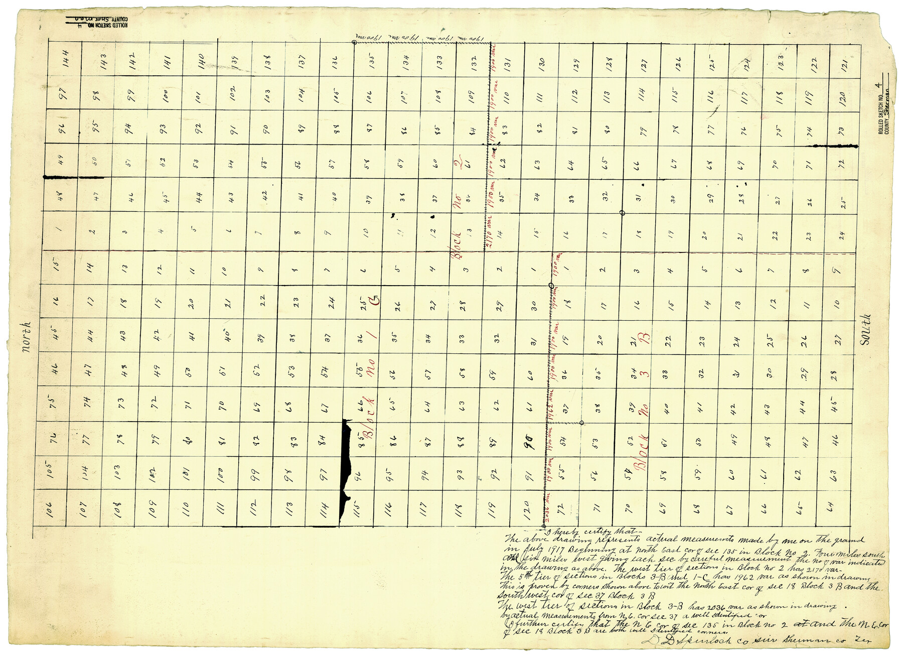
Sherman County Rolled Sketch 4
[Sketch of parts of Blocks IC, 3B, & 2 in Sherman & Hansford Counties, Texas]
-
Map/Doc
7786
-
Collection
General Map Collection
-
Object Dates
7/1917 (Survey Date)
-
People and Organizations
D.D. Spurlock (Surveyor/Engineer)
-
Counties
Sherman Hansford
-
Subjects
Surveying Rolled Sketch
-
Height x Width
23.1 x 31.7 inches
58.7 x 80.5 cm
-
Medium
paper, manuscript
Part of: General Map Collection
Uvalde County Working Sketch 61

Print $20.00
- Digital $50.00
Uvalde County Working Sketch 61
1978
Size 40.4 x 37.4 inches
Map/Doc 72131
Jefferson County

Print $20.00
- Digital $50.00
Jefferson County
1873
Size 22.9 x 19.9 inches
Map/Doc 3728
Tom Green County Sketch File 14

Print $20.00
- Digital $50.00
Tom Green County Sketch File 14
Size 34.8 x 45.7 inches
Map/Doc 10401

Sutton County Rolled Sketch 38

Print $20.00
- Digital $50.00
Sutton County Rolled Sketch 38
1898
Size 19.6 x 35.1 inches
Map/Doc 7881
Hale County Sketch File 27

Print $20.00
- Digital $50.00
Hale County Sketch File 27
Size 12.1 x 28.5 inches
Map/Doc 11598
Jeff Davis County Working Sketch 12

Print $20.00
- Digital $50.00
Jeff Davis County Working Sketch 12
1948
Size 21.5 x 29.0 inches
Map/Doc 66507
Dimmit County Working Sketch 18

Print $20.00
- Digital $50.00
Dimmit County Working Sketch 18
1946
Size 33.5 x 35.0 inches
Map/Doc 68679
Brazoria County Rolled Sketch 22

Print $20.00
- Digital $50.00
Brazoria County Rolled Sketch 22
1929
Size 28.1 x 40.8 inches
Map/Doc 10715
Harrison County Working Sketch 7

Print $20.00
- Digital $50.00
Harrison County Working Sketch 7
1955
Size 32.0 x 39.0 inches
Map/Doc 66027
Newton County Working Sketch 17

Print $20.00
- Digital $50.00
Newton County Working Sketch 17
1950
Size 15.1 x 23.0 inches
Map/Doc 71263
Brazoria County Sketch File 54

Print $8.00
- Digital $50.00
Brazoria County Sketch File 54
1838
Size 13.4 x 8.2 inches
Map/Doc 15323
You may also like
Crane County Rolled Sketch REE

Print $40.00
- Digital $50.00
Crane County Rolled Sketch REE
1936
Size 50.6 x 34.1 inches
Map/Doc 8681
Real County Rolled Sketch 1

Print $20.00
- Digital $50.00
Real County Rolled Sketch 1
1941
Size 20.6 x 28.9 inches
Map/Doc 7452
Childress County Sketch File 18a

Print $4.00
- Digital $50.00
Childress County Sketch File 18a
1935
Size 11.3 x 7.1 inches
Map/Doc 18364
[Reverse of] Plan of the City of Austin
![76228, [Reverse of] Plan of the City of Austin, Texas State Library and Archives](https://historictexasmaps.com/wmedia_w700/maps/76228.tif.jpg)
Print $20.00
[Reverse of] Plan of the City of Austin
1839
Size 19.2 x 24.3 inches
Map/Doc 76228
Polk County Working Sketch 32

Print $20.00
- Digital $50.00
Polk County Working Sketch 32
1960
Size 28.8 x 37.3 inches
Map/Doc 71648

Childress County Sketch File 15

Print $8.00
- Digital $50.00
Childress County Sketch File 15
Size 14.3 x 8.3 inches
Map/Doc 18278
History Salvaged from the Sea

History Salvaged from the Sea
1977
Size 23.0 x 30.4 inches
Map/Doc 96836
Reagan County Working Sketch 14a

Print $20.00
- Digital $50.00
Reagan County Working Sketch 14a
1949
Size 25.9 x 15.2 inches
Map/Doc 71854
Tarrant County Boundary File 82

Print $22.00
- Digital $50.00
Tarrant County Boundary File 82
Size 8.9 x 7.0 inches
Map/Doc 59173
Reeves County Working Sketch 53

Print $40.00
- Digital $50.00
Reeves County Working Sketch 53
1977
Size 70.3 x 42.6 inches
Map/Doc 63496
Kleberg County Rolled Sketch 5

Print $20.00
- Digital $50.00
Kleberg County Rolled Sketch 5
Size 27.8 x 21.8 inches
Map/Doc 6548