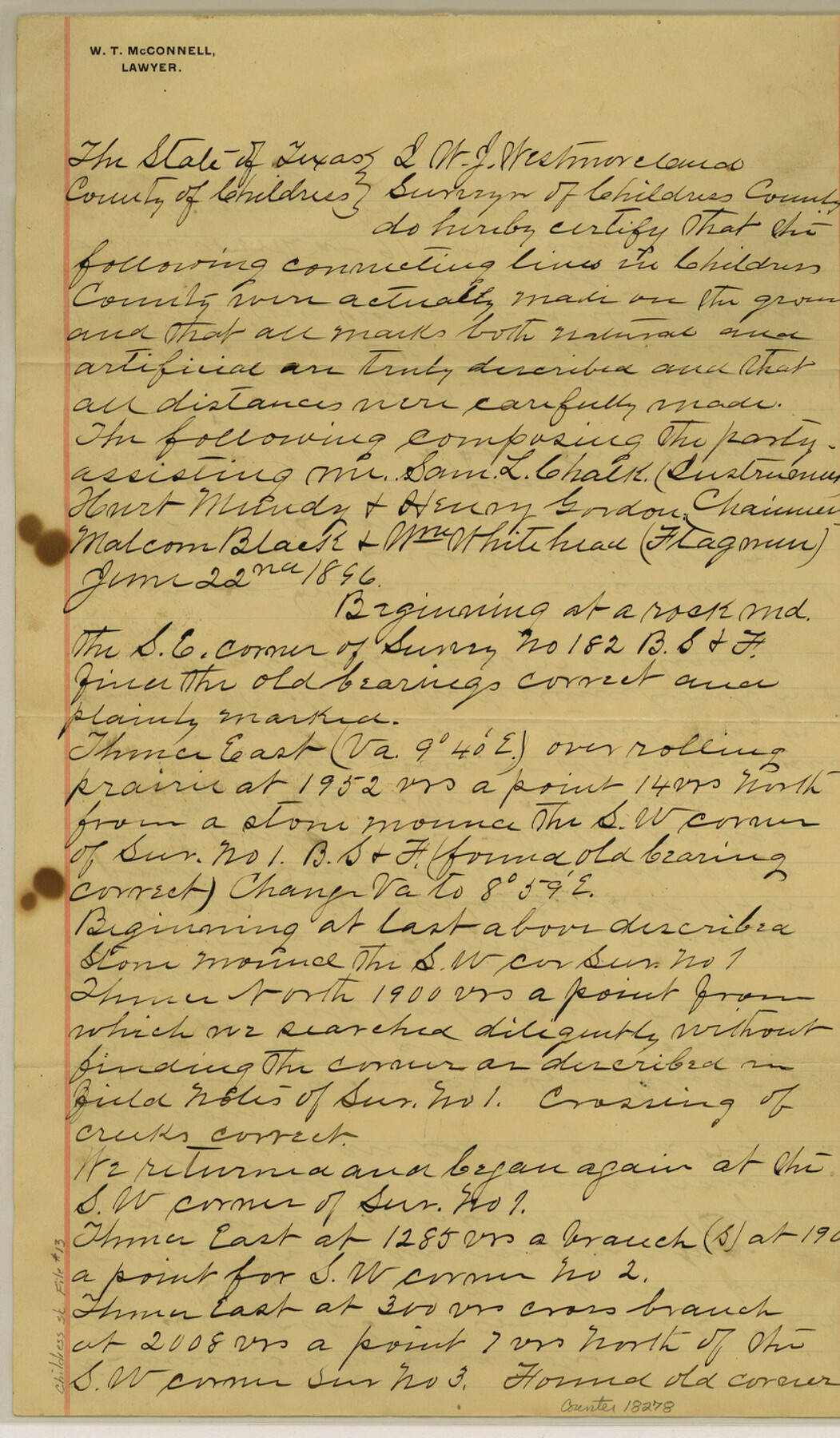
Childress County Sketch File 15
[Field notes of mulitple connecting lines in north part of the county]
-
Map/Doc
18278
-
Collection
General Map Collection
-
Object Dates
1896 (Survey Date)
1896/7/8 (File Date)
-
People and Organizations
W.J. Westmoreland (Surveyor/Engineer)
Hurt Mundy (Chainman/Field Personnel)
Henry Gordon (Chainman/Field Personnel)
Sam L. Chalk (Surveyor/Engineer)
-
Counties
Childress
-
Subjects
Surveying Sketch File
-
Height x Width
14.3 x 8.3 inches
36.3 x 21.1 cm
-
Medium
paper, manuscript
-
Features
Baylor Creek
Red River
Gardners Creek
Myracks Creek
Salt Creek
Part of: General Map Collection
Swisher County Sketch File 19

Print $16.00
- Digital $50.00
Swisher County Sketch File 19
1913
Size 10.0 x 6.5 inches
Map/Doc 37662
Flight Mission No. CRE-2R, Frame 83, Jackson County

Print $20.00
- Digital $50.00
Flight Mission No. CRE-2R, Frame 83, Jackson County
1956
Size 18.6 x 22.3 inches
Map/Doc 85355
Travis County Working Sketch 59

Print $20.00
- Digital $50.00
Travis County Working Sketch 59
1992
Size 33.1 x 29.0 inches
Map/Doc 69443
Real County Working Sketch 45

Print $20.00
- Digital $50.00
Real County Working Sketch 45
1955
Size 23.1 x 18.5 inches
Map/Doc 71937
Bastrop County Working Sketch 16

Print $20.00
- Digital $50.00
Bastrop County Working Sketch 16
1998
Size 39.2 x 34.1 inches
Map/Doc 67316
El Paso County Working Sketch 22

Print $20.00
- Digital $50.00
El Paso County Working Sketch 22
1961
Size 21.6 x 20.0 inches
Map/Doc 69044
Andrews County Sketch File 2

Print $40.00
- Digital $50.00
Andrews County Sketch File 2
1902
Size 20.7 x 29.5 inches
Map/Doc 10807
Newton County Rolled Sketch 27

Print $20.00
- Digital $50.00
Newton County Rolled Sketch 27
1961
Size 36.0 x 27.3 inches
Map/Doc 6856
Sabine Bank to East Bay including Heald Bank

Print $20.00
- Digital $50.00
Sabine Bank to East Bay including Heald Bank
1973
Size 44.8 x 34.5 inches
Map/Doc 69850
Jones County Sketch File 15

Print $40.00
- Digital $50.00
Jones County Sketch File 15
1892
Size 13.7 x 16.3 inches
Map/Doc 28503
Presidio County Rolled Sketch 144

Print $20.00
- Digital $50.00
Presidio County Rolled Sketch 144
2010
Size 36.0 x 24.0 inches
Map/Doc 89603
Archer County Sketch File 13

Print $4.00
- Digital $50.00
Archer County Sketch File 13
Size 11.8 x 8.7 inches
Map/Doc 13648
You may also like
Howard County Boundary File 3

Print $51.00
- Digital $50.00
Howard County Boundary File 3
Size 9.3 x 4.5 inches
Map/Doc 55130
Texas compiled from the latest and best authorities

Print $20.00
- Digital $50.00
Texas compiled from the latest and best authorities
1845
Size 12.0 x 14.6 inches
Map/Doc 93922
Flight Mission No. CUG-1P, Frame 159, Kleberg County

Print $20.00
- Digital $50.00
Flight Mission No. CUG-1P, Frame 159, Kleberg County
1956
Size 18.5 x 22.3 inches
Map/Doc 86166
Gulf Intracoastal Waterway, Tex. - Aransas Bay to Corpus Christi Bay - Modified Route of Main Channel/Dredging

Print $20.00
- Digital $50.00
Gulf Intracoastal Waterway, Tex. - Aransas Bay to Corpus Christi Bay - Modified Route of Main Channel/Dredging
1958
Size 31.2 x 42.5 inches
Map/Doc 61897
The Republic County of Nacogdoches. Spring 1842

Print $20.00
The Republic County of Nacogdoches. Spring 1842
2020
Size 15.9 x 21.8 inches
Map/Doc 96248
Travis County Sketch File 6

Print $8.00
- Digital $50.00
Travis County Sketch File 6
1841
Size 13.8 x 10.9 inches
Map/Doc 38283
Runnels County

Print $20.00
- Digital $50.00
Runnels County
1948
Size 46.5 x 36.4 inches
Map/Doc 77411
Frio County Working Sketch 16

Print $40.00
- Digital $50.00
Frio County Working Sketch 16
1975
Size 52.7 x 39.4 inches
Map/Doc 69290
Jeff Davis County Sketch File 19

Print $10.00
- Digital $50.00
Jeff Davis County Sketch File 19
1908
Size 14.4 x 8.8 inches
Map/Doc 27973
Brewster County Rolled Sketch 73

Print $20.00
- Digital $50.00
Brewster County Rolled Sketch 73
1938
Size 19.7 x 23.3 inches
Map/Doc 5239
[Map Showing Surveys in Dimmit & La Salle Counties, Texas]
![75791, [Map Showing Surveys in Dimmit & La Salle Counties, Texas], Maddox Collection](https://historictexasmaps.com/wmedia_w700/maps/75791.tif.jpg)
Print $20.00
- Digital $50.00
[Map Showing Surveys in Dimmit & La Salle Counties, Texas]
Size 29.5 x 29.5 inches
Map/Doc 75791
Greer County Sketch File 9

Print $6.00
- Digital $50.00
Greer County Sketch File 9
Size 15.9 x 11.4 inches
Map/Doc 24528