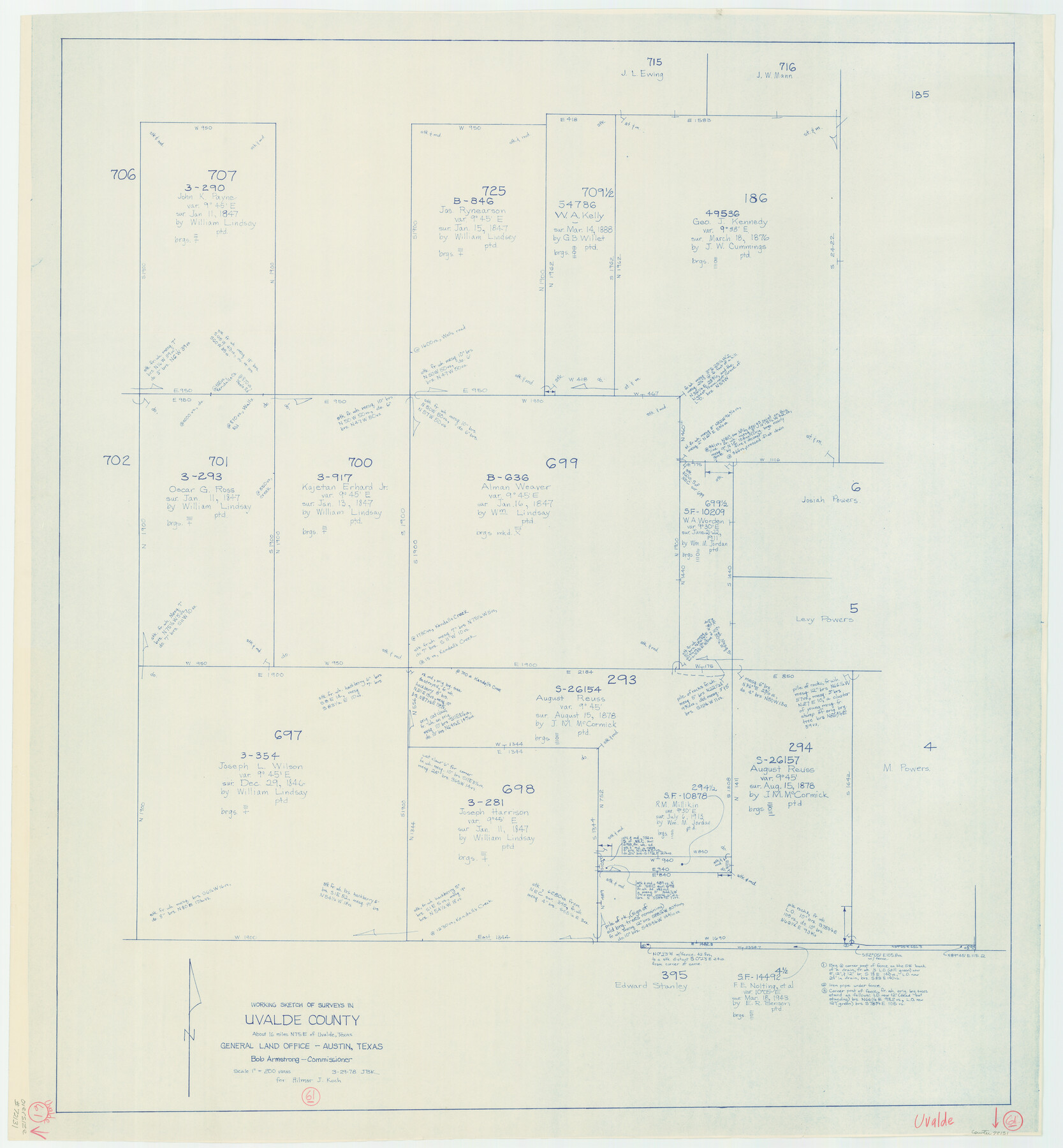
Uvalde County Working Sketch 61
-
Map/Doc
72131
-
Collection
General Map Collection
-
Object Dates
3/29/1978 (Creation Date)
-
People and Organizations
Joan Kilpatrick (Draftsman)
-
Counties
Uvalde
-
Subjects
Surveying Working Sketch
-
Height x Width
40.4 x 37.4 inches
102.6 x 95.0 cm
-
Scale
1" = 200 varas
Part of: General Map Collection
Clay County Working Sketch Graphic Index

Print $40.00
- Digital $50.00
Clay County Working Sketch Graphic Index
1971
Size 58.4 x 34.3 inches
Map/Doc 76494
Location St. L. & S. W. R. R. Through Cherokee County

Print $40.00
- Digital $50.00
Location St. L. & S. W. R. R. Through Cherokee County
Size 108.6 x 39.0 inches
Map/Doc 64043
El Paso County Rolled Sketch 52

Print $20.00
- Digital $50.00
El Paso County Rolled Sketch 52
1932
Size 18.3 x 24.3 inches
Map/Doc 5843
Motley County Sketch File 18 (N)

Print $4.00
- Digital $50.00
Motley County Sketch File 18 (N)
1913
Size 11.3 x 8.7 inches
Map/Doc 32062

Map of the Fort Worth & Denver City Railway

Print $20.00
- Digital $50.00
Map of the Fort Worth & Denver City Railway
1887
Size 19.3 x 15.1 inches
Map/Doc 64434
Greater San Antonio & Surrounding Area

Greater San Antonio & Surrounding Area
Size 36.1 x 46.0 inches
Map/Doc 96869
Red River County Working Sketch 1

Print $20.00
- Digital $50.00
Red River County Working Sketch 1
1918
Size 26.8 x 22.1 inches
Map/Doc 71984
Hardin County Sketch File 54

Print $20.00
- Digital $50.00
Hardin County Sketch File 54
1924
Size 16.6 x 17.9 inches
Map/Doc 11635

Aransas County Sketch File 38

Print $244.00
- Digital $50.00
Aransas County Sketch File 38
1996
Size 11.1 x 8.7 inches
Map/Doc 13465
Terrell County Working Sketch 22

Print $20.00
- Digital $50.00
Terrell County Working Sketch 22
1937
Size 28.8 x 26.5 inches
Map/Doc 62172
You may also like
Ochiltree County Boundary File 2

Print $4.00
- Digital $50.00
Ochiltree County Boundary File 2
Size 7.7 x 8.6 inches
Map/Doc 57675
Hardin County Working Sketch 39, part 2

Print $40.00
- Digital $50.00
Hardin County Working Sketch 39, part 2
1985
Size 36.0 x 48.5 inches
Map/Doc 63438
Stonewall County Working Sketch 15

Print $20.00
- Digital $50.00
Stonewall County Working Sketch 15
1954
Size 32.3 x 30.8 inches
Map/Doc 62322
Crockett County Rolled Sketch 79

Print $20.00
- Digital $50.00
Crockett County Rolled Sketch 79
1954
Size 36.1 x 47.8 inches
Map/Doc 76013
Houston County Sketch File 20

Print $6.00
- Digital $50.00
Houston County Sketch File 20
1884
Size 16.9 x 11.3 inches
Map/Doc 26787
[Texas & Pacific Railway, Longview to Dallas]
![64098, [Texas & Pacific Railway, Longview to Dallas], General Map Collection](https://historictexasmaps.com/wmedia_w700/maps/64098.tif.jpg)
Print $40.00
- Digital $50.00
[Texas & Pacific Railway, Longview to Dallas]
1873
Size 14.5 x 121.6 inches
Map/Doc 64098
Comanche County Sketch File 24 1/2

Print $6.00
- Digital $50.00
Comanche County Sketch File 24 1/2
Size 10.5 x 15.8 inches
Map/Doc 19113
Nueces County Sketch File 81

Print $20.00
- Digital $50.00
Nueces County Sketch File 81
Size 11.2 x 8.7 inches
Map/Doc 33155
Hudspeth County Working Sketch 27

Print $40.00
- Digital $50.00
Hudspeth County Working Sketch 27
1972
Size 31.0 x 51.2 inches
Map/Doc 66309
[Southeast part of County near Jas. H. Price Survey]
![91888, [Southeast part of County near Jas. H. Price Survey], Twichell Survey Records](https://historictexasmaps.com/wmedia_w700/maps/91888-1.tif.jpg)
Print $20.00
- Digital $50.00
[Southeast part of County near Jas. H. Price Survey]
Size 19.3 x 19.3 inches
Map/Doc 91888
Jackson County Sketch File 15

Print $13.00
- Digital $50.00
Jackson County Sketch File 15
Size 13.5 x 8.8 inches
Map/Doc 27662
Galveston County Working Sketch 2

Print $20.00
- Digital $50.00
Galveston County Working Sketch 2
1924
Size 24.1 x 26.3 inches
Map/Doc 69339