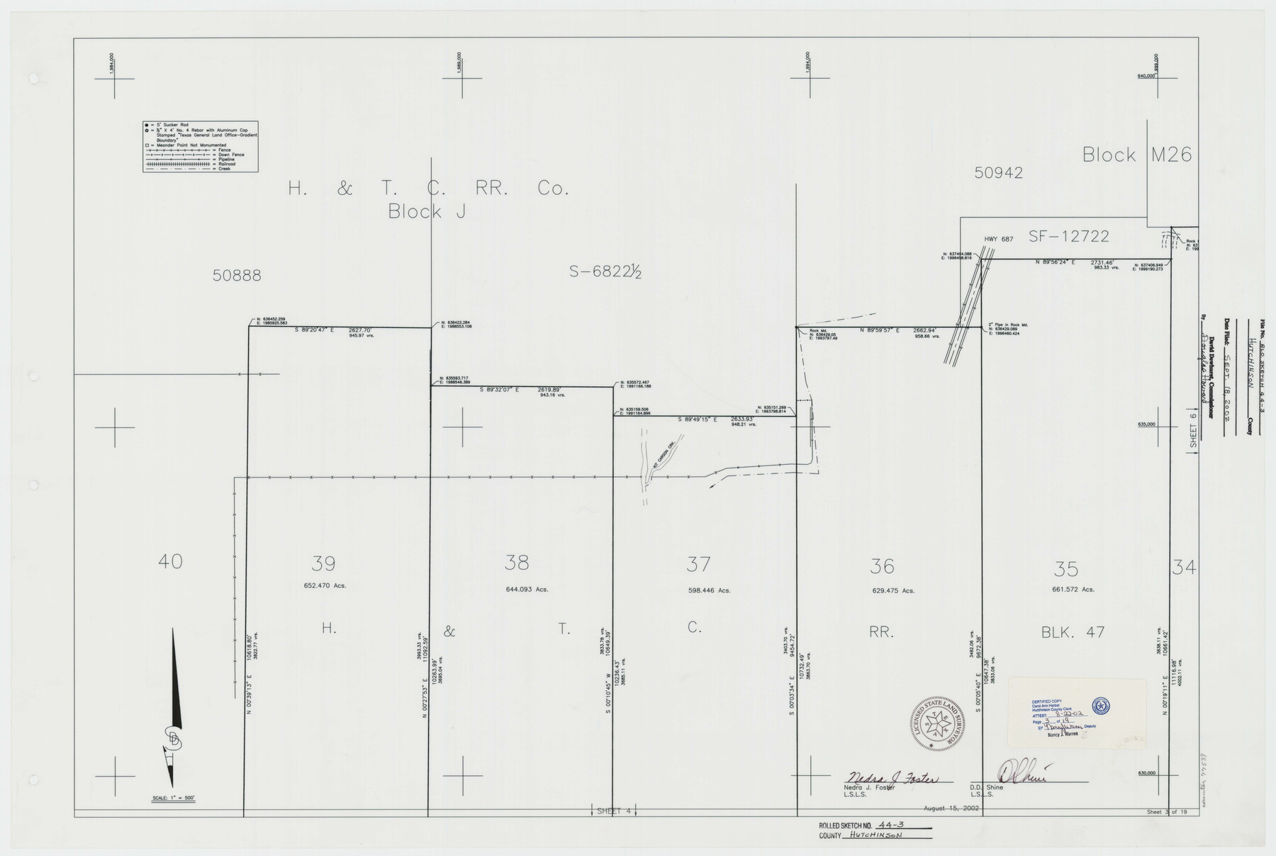
Hutchinson County Rolled Sketch 44-3
Canadian River Survey, Hutchinson County, Texas [Sheet 3 of 19]
-
Map/Doc
77539
-
Collection
General Map Collection
-
Object Dates
2002/8/15 (Creation Date)
2002/9/18 (File Date)
-
People and Organizations
Nedra J. Foster (Surveyor/Engineer)
D.D. Shine (Surveyor/Engineer)
-
Counties
Hutchinson
-
Subjects
Surveying Rolled Sketch
-
Height x Width
24.0 x 36.0 inches
61.0 x 91.4 cm
-
Medium
mylar, print
-
Scale
1" = 500 feet
Part of: General Map Collection
Flight Mission No. DQN-2K, Frame 31, Calhoun County

Print $20.00
- Digital $50.00
Flight Mission No. DQN-2K, Frame 31, Calhoun County
1953
Size 18.7 x 22.3 inches
Map/Doc 84238
Runnels County Rolled Sketch 34

Print $20.00
- Digital $50.00
Runnels County Rolled Sketch 34
Size 30.1 x 35.1 inches
Map/Doc 7522
Atascosa County Sketch File 2a

Print $40.00
- Digital $50.00
Atascosa County Sketch File 2a
Size 25.1 x 15.3 inches
Map/Doc 10858
Flight Mission No. CRC-2R, Frame 1, Chambers County

Print $20.00
- Digital $50.00
Flight Mission No. CRC-2R, Frame 1, Chambers County
1956
Size 18.7 x 22.5 inches
Map/Doc 84720
San Bernard River, Texas showing possible connection with Brazos River and part of possible connection with Matagorda Bay for a Light Draft Navigation

Print $40.00
- Digital $50.00
San Bernard River, Texas showing possible connection with Brazos River and part of possible connection with Matagorda Bay for a Light Draft Navigation
Size 17.2 x 56.1 inches
Map/Doc 96561
Duval County Working Sketch 27

Print $20.00
- Digital $50.00
Duval County Working Sketch 27
1947
Size 20.7 x 16.8 inches
Map/Doc 68751
Flight Mission No. DIX-6P, Frame 183, Aransas County

Print $20.00
- Digital $50.00
Flight Mission No. DIX-6P, Frame 183, Aransas County
1956
Size 19.1 x 22.7 inches
Map/Doc 83845
Flight Mission No. DIX-6P, Frame 186, Aransas County

Print $20.00
- Digital $50.00
Flight Mission No. DIX-6P, Frame 186, Aransas County
1956
Size 19.2 x 22.9 inches
Map/Doc 83848
Presidio County Rolled Sketch 30

Print $40.00
- Digital $50.00
Presidio County Rolled Sketch 30
Size 40.8 x 84.9 inches
Map/Doc 9767
Hunt County Boundary File 2b

Print $2.00
- Digital $50.00
Hunt County Boundary File 2b
Size 12.8 x 7.9 inches
Map/Doc 55207
Brewster County Sketch File N-3a

Print $40.00
- Digital $50.00
Brewster County Sketch File N-3a
Size 14.5 x 18.9 inches
Map/Doc 10962
Flight Mission No. BQY-15M, Frame 17, Harris County

Print $20.00
- Digital $50.00
Flight Mission No. BQY-15M, Frame 17, Harris County
1953
Size 18.5 x 22.2 inches
Map/Doc 85315
You may also like
Crockett County Sketch File 86

Print $4.00
- Digital $50.00
Crockett County Sketch File 86
1939
Size 11.5 x 9.1 inches
Map/Doc 19908
Township 14 South Range 14 West, South Western District, Louisiana

Print $20.00
- Digital $50.00
Township 14 South Range 14 West, South Western District, Louisiana
1838
Size 19.5 x 24.8 inches
Map/Doc 65858

Jasper County Working Sketch 8

Print $20.00
- Digital $50.00
Jasper County Working Sketch 8
1915
Size 20.1 x 31.4 inches
Map/Doc 66470
Aransas County Working Sketch 18

Print $20.00
- Digital $50.00
Aransas County Working Sketch 18
1961
Size 36.0 x 30.7 inches
Map/Doc 67185
[Block V and surrounding surveys]
![90293, [Block V and surrounding surveys], Twichell Survey Records](https://historictexasmaps.com/wmedia_w700/maps/90293-1.tif.jpg)
Print $20.00
- Digital $50.00
[Block V and surrounding surveys]
Size 12.0 x 12.6 inches
Map/Doc 90293
[West Part of Claude E. Halsell's Survey Section 6 Block A7]
![91063, [West Part of Claude E. Halsell's Survey Section 6 Block A7], Twichell Survey Records](https://historictexasmaps.com/wmedia_w700/maps/91063-1.tif.jpg)
Print $2.00
- Digital $50.00
[West Part of Claude E. Halsell's Survey Section 6 Block A7]
Size 9.2 x 14.7 inches
Map/Doc 91063
Angelina County Sketch File 17a

Print $8.00
- Digital $50.00
Angelina County Sketch File 17a
1863
Size 13.1 x 8.2 inches
Map/Doc 13024
Culberson County Sketch File 32

Print $22.00
- Digital $50.00
Culberson County Sketch File 32
1952
Size 11.2 x 8.7 inches
Map/Doc 20285
Mason County Sketch File 10

Print $6.00
- Digital $50.00
Mason County Sketch File 10
1885
Size 12.8 x 11.6 inches
Map/Doc 30693
Hays County Sketch File 32

Print $8.00
- Digital $50.00
Hays County Sketch File 32
Size 14.3 x 8.8 inches
Map/Doc 26264
Survey of The Rio Grande Roma to the Gulf of Mexico

Survey of The Rio Grande Roma to the Gulf of Mexico
Map/Doc 81739