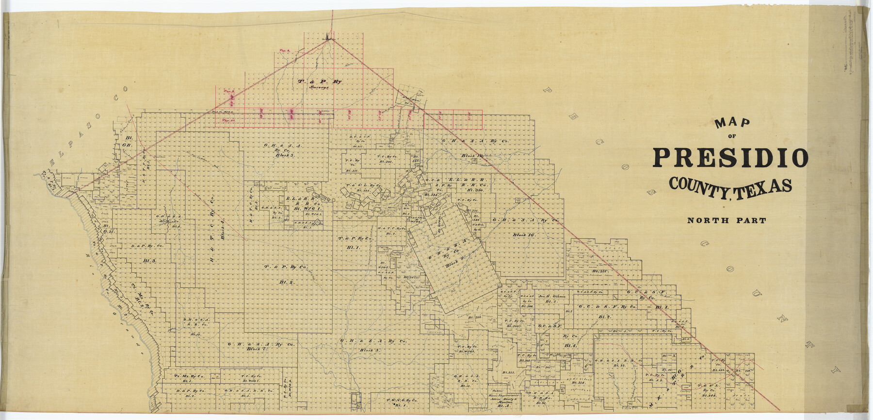
Presidio County Rolled Sketch 30
Map of Presidio County, Texas - North Part
-
Map/Doc
9767
-
Collection
General Map Collection
-
Counties
Presidio Jeff Davis Brewster
-
Subjects
Surveying Rolled Sketch
-
Height x Width
40.8 x 84.9 inches
103.6 x 215.6 cm
-
Medium
linen, manuscript
-
Comments
For south part see Presidio County Rolled Sketch 31 (9768)
Related maps
Presidio County Rolled Sketch 31

Print $40.00
- Digital $50.00
Presidio County Rolled Sketch 31
Size 41.1 x 82.1 inches
Map/Doc 9768
Part of: General Map Collection
Panola County Working Sketch 5

Print $20.00
- Digital $50.00
Panola County Working Sketch 5
1940
Map/Doc 71414
Roberts County Working Sketch 16

Print $20.00
- Digital $50.00
Roberts County Working Sketch 16
1975
Size 37.1 x 39.8 inches
Map/Doc 63542
Flight Mission No. DIX-8P, Frame 58, Aransas County

Print $20.00
- Digital $50.00
Flight Mission No. DIX-8P, Frame 58, Aransas County
1956
Size 18.6 x 22.5 inches
Map/Doc 83889
Tarrant County Sketch File 10a

Print $6.00
- Digital $50.00
Tarrant County Sketch File 10a
1860
Size 10.3 x 8.1 inches
Map/Doc 37691
Briscoe County Rolled Sketch 11A

Print $20.00
- Digital $50.00
Briscoe County Rolled Sketch 11A
1913
Size 11.7 x 12.3 inches
Map/Doc 5329
Val Verde County Sketch File Z8

Print $20.00
- Digital $50.00
Val Verde County Sketch File Z8
1884
Size 25.2 x 19.9 inches
Map/Doc 12553
Kerr County Rolled Sketch 17

Print $20.00
- Digital $50.00
Kerr County Rolled Sketch 17
1953
Size 37.0 x 23.0 inches
Map/Doc 6499
Sutton County Rolled Sketch 66

Print $20.00
- Digital $50.00
Sutton County Rolled Sketch 66
Size 25.3 x 25.1 inches
Map/Doc 7901
Brazoria County Rolled Sketch 50A

Print $20.00
- Digital $50.00
Brazoria County Rolled Sketch 50A
1932
Size 17.8 x 26.1 inches
Map/Doc 5188
Taylor County Sketch File 19

Print $10.00
- Digital $50.00
Taylor County Sketch File 19
1945
Size 14.2 x 8.8 inches
Map/Doc 37816
Edwards County Working Sketch 133

Print $20.00
- Digital $50.00
Edwards County Working Sketch 133
1985
Size 29.7 x 38.9 inches
Map/Doc 69009
Map of La Salle County

Print $20.00
- Digital $50.00
Map of La Salle County
1877
Size 29.8 x 21.1 inches
Map/Doc 3797
You may also like
Webb County Working Sketch 79

Print $20.00
- Digital $50.00
Webb County Working Sketch 79
1977
Size 31.0 x 28.3 inches
Map/Doc 72446
Grimes County Working Sketch 13

Print $20.00
- Digital $50.00
Grimes County Working Sketch 13
1982
Size 39.4 x 47.7 inches
Map/Doc 63304
Harbor of Brazos Santiago, Texas

Print $20.00
- Digital $50.00
Harbor of Brazos Santiago, Texas
1887
Size 27.2 x 18.4 inches
Map/Doc 72996
Hardin County Working Sketch 38

Print $20.00
- Digital $50.00
Hardin County Working Sketch 38
1981
Size 37.2 x 19.4 inches
Map/Doc 63436
Texas & Pacific R. R. through Pecos-Presidio Counties

Print $40.00
- Digital $50.00
Texas & Pacific R. R. through Pecos-Presidio Counties
Size 20.3 x 70.7 inches
Map/Doc 64282
Travis County Working Sketch 68

Print $20.00
- Digital $50.00
Travis County Working Sketch 68
2019
Size 23.8 x 36.0 inches
Map/Doc 95687
Newton County Sketch File 24

Print $4.00
- Digital $50.00
Newton County Sketch File 24
1881
Size 8.4 x 8.1 inches
Map/Doc 32405
El Paso County Rolled Sketch 54

Print $20.00
- Digital $50.00
El Paso County Rolled Sketch 54
1980
Size 30.4 x 42.8 inches
Map/Doc 44539
Trinity River, Wire Bridge Sheet/Denton Creek

Print $6.00
- Digital $50.00
Trinity River, Wire Bridge Sheet/Denton Creek
1938
Size 30.4 x 29.7 inches
Map/Doc 65244
Robertson County Working Sketch 14

Print $40.00
- Digital $50.00
Robertson County Working Sketch 14
1988
Size 50.0 x 40.8 inches
Map/Doc 78227
Flight Mission No. BQR-9K, Frame 12, Brazoria County

Print $20.00
- Digital $50.00
Flight Mission No. BQR-9K, Frame 12, Brazoria County
1952
Size 18.8 x 22.3 inches
Map/Doc 84041
Flight Mission No. BQR-22K, Frame 43, Brazoria County

Print $20.00
- Digital $50.00
Flight Mission No. BQR-22K, Frame 43, Brazoria County
1953
Size 18.6 x 22.3 inches
Map/Doc 84127