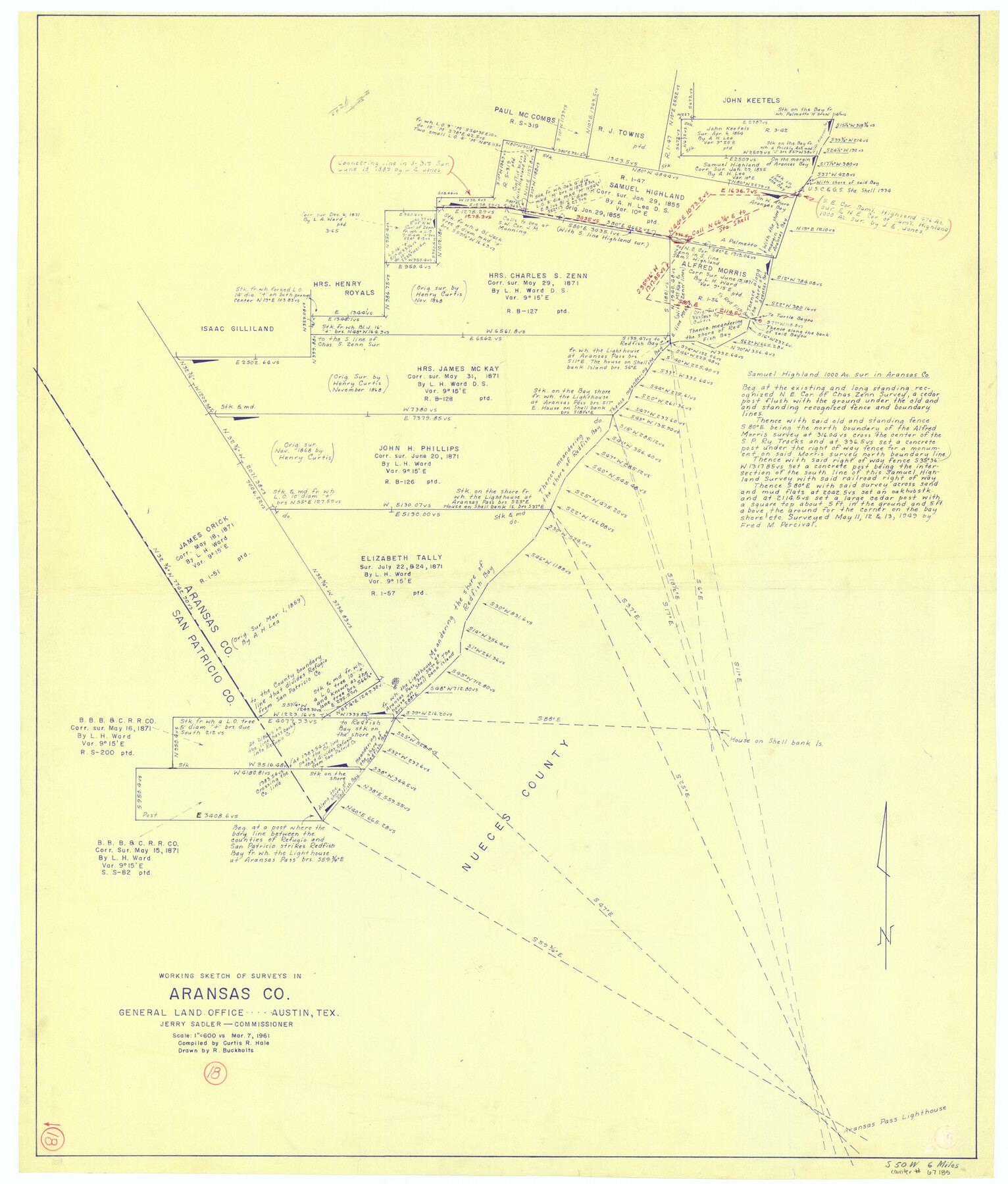
Aransas County Working Sketch 18
-
Map/Doc
67185
-
Collection
General Map Collection
-
Object Dates
3/7/1961 (Creation Date)
-
People and Organizations
Roy Buckholts (Draftsman)
Jerry Sadler (GLO Commissioner)
Curtis R. Hale (Compiler)
-
Counties
Aransas San Patricio Nueces
-
Subjects
Surveying Working Sketch
-
Height x Width
36.0 x 30.7 inches
91.4 x 78.0 cm
-
Scale
1" = 600 varas
-
Comments
Surveys located about six miles South 50 degrees West of Rockport, Texas.
Part of: General Map Collection
Travis County Sketch File 60

Print $20.00
- Digital $50.00
Travis County Sketch File 60
1945
Size 23.0 x 15.9 inches
Map/Doc 12472
Potter County Working Sketch 13

Print $20.00
- Digital $50.00
Potter County Working Sketch 13
1980
Size 19.5 x 26.9 inches
Map/Doc 71673
Harris County Sketch File 22

Print $4.00
- Digital $50.00
Harris County Sketch File 22
1862
Size 9.1 x 9.4 inches
Map/Doc 25375
Limestone County Sketch File 2

Print $2.00
- Digital $50.00
Limestone County Sketch File 2
Size 8.0 x 6.2 inches
Map/Doc 30157
Edwards County Rolled Sketch 29

Print $40.00
- Digital $50.00
Edwards County Rolled Sketch 29
1974
Size 49.1 x 29.1 inches
Map/Doc 8847

[Sketch for Mineral Application 16341 - Clear Fork of Brazos River, Taylor & Holcomb]
![65571, [Sketch for Mineral Application 16341 - Clear Fork of Brazos River, Taylor & Holcomb], General Map Collection](https://historictexasmaps.com/wmedia_w700/maps/65571.tif.jpg)
Print $40.00
- Digital $50.00
[Sketch for Mineral Application 16341 - Clear Fork of Brazos River, Taylor & Holcomb]
1926
Size 122.3 x 36.7 inches
Map/Doc 65571
Wheeler County Sketch File 11

Print $47.00
- Digital $50.00
Wheeler County Sketch File 11
1992
Size 11.5 x 9.0 inches
Map/Doc 40014
Throckmorton County Sketch File 8

Print $66.00
- Digital $50.00
Throckmorton County Sketch File 8
Size 24.0 x 32.4 inches
Map/Doc 12433
Cuadro Historico-Geroglifico de la Peregrinacion de las Tribus Aztecas que Poblaron el Valle de Mexico (Num. 1)

Print $20.00
- Digital $50.00
Cuadro Historico-Geroglifico de la Peregrinacion de las Tribus Aztecas que Poblaron el Valle de Mexico (Num. 1)
Size 22.9 x 31.2 inches
Map/Doc 97013
Texas Gulf Coast Map from the Sabine River to the Rio Grande as subdivided for mineral development

Print $20.00
- Digital $50.00
Texas Gulf Coast Map from the Sabine River to the Rio Grande as subdivided for mineral development
1948
Size 41.6 x 39.2 inches
Map/Doc 2904
Travis County Rolled Sketch 42

Print $20.00
- Digital $50.00
Travis County Rolled Sketch 42
Size 25.2 x 25.7 inches
Map/Doc 8040
You may also like
Map of Montague County

Print $20.00
- Digital $50.00
Map of Montague County
1868
Size 24.1 x 19.7 inches
Map/Doc 3887
Louisiana and Texas Intracoastal Waterway

Print $20.00
- Digital $50.00
Louisiana and Texas Intracoastal Waterway
1937
Size 13.7 x 19.6 inches
Map/Doc 83348
Brazoria County Sketch File 51

Print $380.00
- Digital $50.00
Brazoria County Sketch File 51
1926
Size 14.1 x 7.8 inches
Map/Doc 15125
Presidio County Sketch File 105

Print $20.00
- Digital $50.00
Presidio County Sketch File 105
Size 15.6 x 42.6 inches
Map/Doc 11726
Bell County Working Sketch 18

Print $20.00
- Digital $50.00
Bell County Working Sketch 18
1984
Size 36.2 x 29.8 inches
Map/Doc 67358
City Leased Property in Bailey County, Texas

Print $40.00
- Digital $50.00
City Leased Property in Bailey County, Texas
1952
Size 65.9 x 42.7 inches
Map/Doc 89868
[Blocks 178, 194, Z]
![91579, [Blocks 178, 194, Z], Twichell Survey Records](https://historictexasmaps.com/wmedia_w700/maps/91579-1.tif.jpg)
Print $3.00
- Digital $50.00
[Blocks 178, 194, Z]
Size 12.8 x 10.5 inches
Map/Doc 91579
Crane County Working Sketch 26

Print $20.00
- Digital $50.00
Crane County Working Sketch 26
1971
Size 32.4 x 33.0 inches
Map/Doc 68303

Jackson County Working Sketch Graphic Index

Print $20.00
- Digital $50.00
Jackson County Working Sketch Graphic Index
1920
Size 47.0 x 40.3 inches
Map/Doc 76590
Jim Hogg County Rolled Sketch 14

Print $20.00
- Digital $50.00
Jim Hogg County Rolled Sketch 14
2023
Size 21.1 x 30.3 inches
Map/Doc 97155
Brazoria County Sketch File 14

Print $8.00
- Digital $50.00
Brazoria County Sketch File 14
1892
Size 13.9 x 8.7 inches
Map/Doc 14973