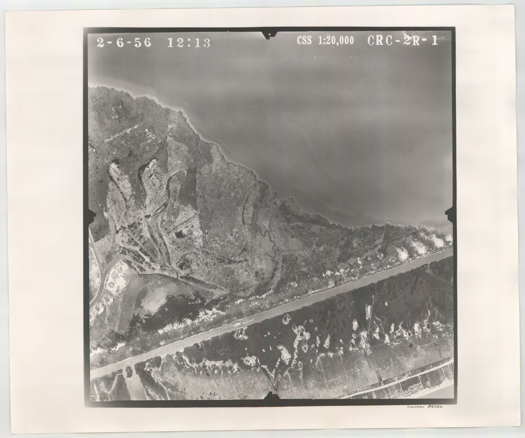
Flight Mission No. CRC-2R, Frame 1, Chambers County
CRC-2R-1
-
Map/Doc
84720
-
Collection
General Map Collection
-
Object Dates
1956/2/6 (Creation Date)
-
People and Organizations
U. S. Department of Agriculture (Publisher)
-
Counties
Chambers
-
Subjects
Aerial Photograph
-
Height x Width
18.7 x 22.5 inches
47.5 x 57.2 cm
-
Comments
Flown by Jack Ammann Photogrammetric Engineers, Inc. of San Antonio, Texas.
Part of: General Map Collection
Blanco County Boundary File 7

Print $58.00
- Digital $50.00
Blanco County Boundary File 7
Size 14.3 x 8.5 inches
Map/Doc 50565
[Right of Way Map, Belton Branch of the M.K.&T. RR.]
![64222, [Right of Way Map, Belton Branch of the M.K.&T. RR.], General Map Collection](https://historictexasmaps.com/wmedia_w700/maps/64222.tif.jpg)
Print $20.00
- Digital $50.00
[Right of Way Map, Belton Branch of the M.K.&T. RR.]
1896
Size 21.9 x 7.4 inches
Map/Doc 64222
Marion County Rolled Sketch S

Print $20.00
- Digital $50.00
Marion County Rolled Sketch S
1937
Size 18.8 x 18.1 inches
Map/Doc 6663
Jefferson County Rolled Sketch 32

Print $40.00
- Digital $50.00
Jefferson County Rolled Sketch 32
1955
Size 26.4 x 49.3 inches
Map/Doc 9295
Real County Sketch File 16

Print $20.00
- Digital $50.00
Real County Sketch File 16
1934
Size 23.1 x 22.1 inches
Map/Doc 12234
Flight Mission No. BRA-7M, Frame 84, Jefferson County

Print $20.00
- Digital $50.00
Flight Mission No. BRA-7M, Frame 84, Jefferson County
1953
Size 18.6 x 22.3 inches
Map/Doc 85506
[Drawings of individual counties for Pressler and Langermann's 1879 Map of Texas]
![[Drawings of individual counties for Pressler and Langermann's 1879 Map of Texas]](https://historictexasmaps.com/wmedia_w700/maps/4864.tif.jpg)
Print $20.00
- Digital $50.00
[Drawings of individual counties for Pressler and Langermann's 1879 Map of Texas]
1878
Size 38.3 x 26.8 inches
Map/Doc 4864
Texas Gulf Coast Bay Index Map

Print $20.00
- Digital $50.00
Texas Gulf Coast Bay Index Map
Size 43.7 x 42.6 inches
Map/Doc 73599
Fisher County Rolled Sketch 3

Print $20.00
- Digital $50.00
Fisher County Rolled Sketch 3
Size 40.5 x 38.6 inches
Map/Doc 8887
Morris County Rolled Sketch 2A

Print $20.00
- Digital $50.00
Morris County Rolled Sketch 2A
Size 22.7 x 17.6 inches
Map/Doc 10268
Hardin County

Print $40.00
- Digital $50.00
Hardin County
1940
Size 48.8 x 44.3 inches
Map/Doc 95521
Howard County State Real Property Sketch 1

Print $40.00
- Digital $50.00
Howard County State Real Property Sketch 1
2007
Size 24.3 x 35.2 inches
Map/Doc 88673
You may also like
[Southwest part of B. S. & F. Block and surveys to the south]
![90389, [Southwest part of B. S. & F. Block and surveys to the south], Twichell Survey Records](https://historictexasmaps.com/wmedia_w700/maps/90389-1.tif.jpg)
Print $3.00
- Digital $50.00
[Southwest part of B. S. & F. Block and surveys to the south]
Size 11.1 x 10.3 inches
Map/Doc 90389
Mason County Working Sketch 15

Print $40.00
- Digital $50.00
Mason County Working Sketch 15
1976
Size 61.9 x 45.4 inches
Map/Doc 70851
Jefferson County Rolled Sketch 25A

Print $20.00
- Digital $50.00
Jefferson County Rolled Sketch 25A
Size 24.4 x 39.6 inches
Map/Doc 6389
[Galveston, Harrisburg & San Antonio Railroad from Cuero to Stockdale]
![64187, [Galveston, Harrisburg & San Antonio Railroad from Cuero to Stockdale], General Map Collection](https://historictexasmaps.com/wmedia_w700/maps/64187.tif.jpg)
Print $20.00
- Digital $50.00
[Galveston, Harrisburg & San Antonio Railroad from Cuero to Stockdale]
1906
Size 13.3 x 32.9 inches
Map/Doc 64187
Louisiana and Texas for the Winter Tourist

Louisiana and Texas for the Winter Tourist
1911
Map/Doc 96716
Wise County Sketch File 23

Print $4.00
- Digital $50.00
Wise County Sketch File 23
1859
Size 7.9 x 12.9 inches
Map/Doc 40568
Mitchell's school atlas: comprising the maps, etc., designed to illustrate Mitchell's school and family geography

Print $370.00
- Digital $50.00
Mitchell's school atlas: comprising the maps, etc., designed to illustrate Mitchell's school and family geography
1851
Size 12.0 x 9.6 inches
Map/Doc 93491
McCulloch County Sketch File 5

Print $11.00
- Digital $50.00
McCulloch County Sketch File 5
1899
Size 17.5 x 9.2 inches
Map/Doc 31177
Henderson County Sketch File 6

Print $4.00
- Digital $50.00
Henderson County Sketch File 6
1857
Size 10.0 x 8.1 inches
Map/Doc 26327
Flight Mission No. CUI-1H, Frame 141, Milam County

Print $20.00
- Digital $50.00
Flight Mission No. CUI-1H, Frame 141, Milam County
1951
Size 18.4 x 22.3 inches
Map/Doc 86607
Hudspeth County Working Sketch 29

Print $40.00
- Digital $50.00
Hudspeth County Working Sketch 29
1972
Size 31.5 x 55.2 inches
Map/Doc 66311
Van Zandt County Rolled Sketch 5

Print $20.00
- Digital $50.00
Van Zandt County Rolled Sketch 5
1946
Size 27.1 x 28.1 inches
Map/Doc 8146