Angelina County Sketch File 17a
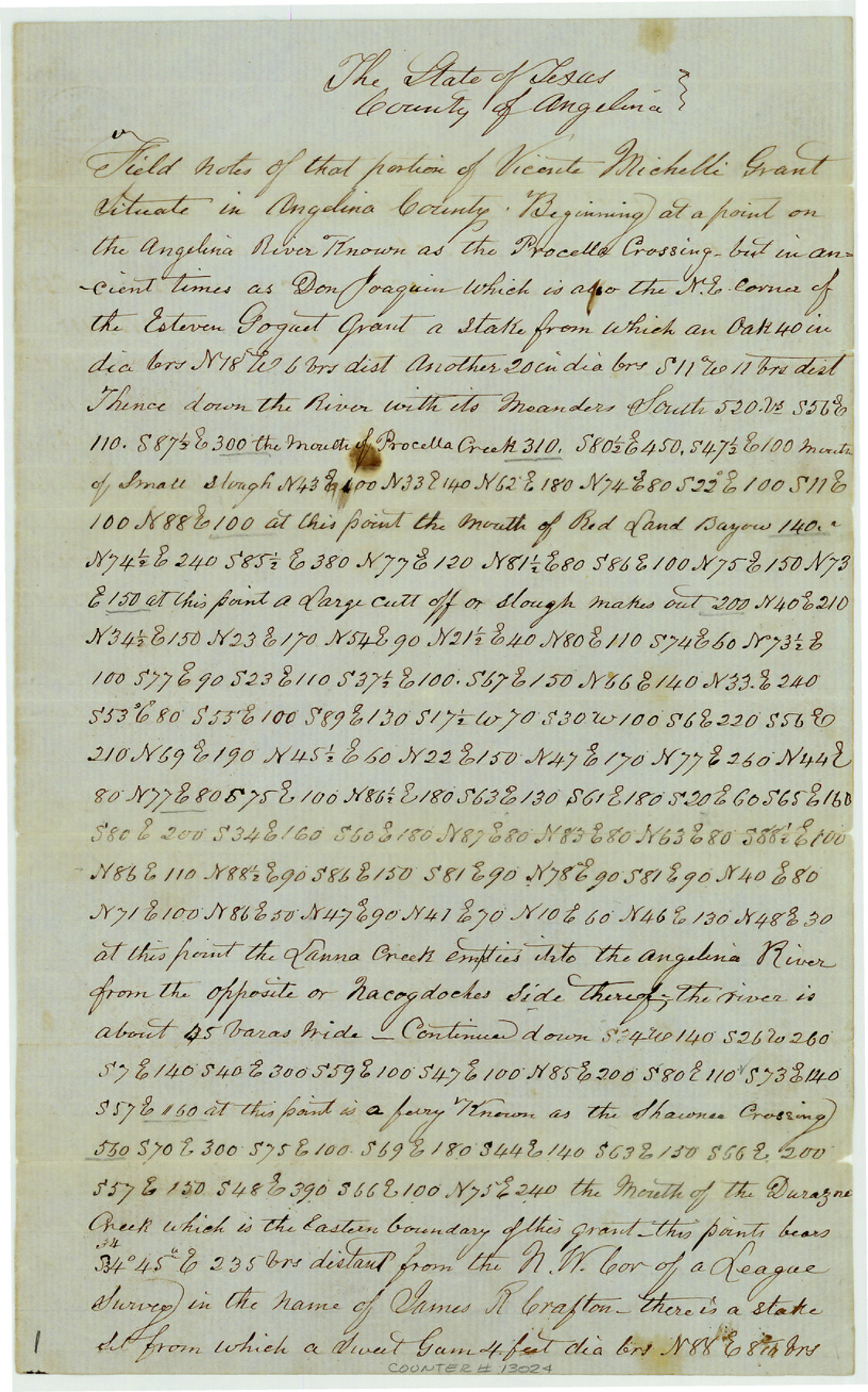
Field notes of that portion of Vicente Micheli grant situated in Angelina County
-
Map/Doc
13024
-
Collection
General Map Collection
-
Object Dates
1863/11/28 (Creation Date)
1864/4/13 (File Date)
-
People and Organizations
W.G. Lang (Surveyor/Engineer)
James Smith (Chainman)
James Martin (Chainman)
Morris Martin (Chainman)
Page Massongill (Chainman)
-
Counties
Angelina
-
Subjects
Surveying Sketch File
-
Height x Width
13.1 x 8.2 inches
33.3 x 20.8 cm
-
Medium
paper, manuscript
-
Features
Parisaqua Creek
Neighborhood Road
King's Highway
Jack's Creek
Monsola Creek
Alabama Trail
Michelli Prairie
Burris Prairie
Middle Prong of Durazno Creek
Angelina River
Alto Road
Durazno Creek
Shawnee Crossing
Nacogdoches River
Lanna Creek
Red Land Bayou
Procella Crossing
Part of: General Map Collection
Bee County Sketch File 18

Print $6.00
- Digital $50.00
Bee County Sketch File 18
1880
Size 11.8 x 10.3 inches
Map/Doc 14303
Nueces County NRC Article 33.136 Sketch 13

Print $24.00
- Digital $50.00
Nueces County NRC Article 33.136 Sketch 13
2007
Size 22.3 x 34.3 inches
Map/Doc 88809
Maps of Gulf Intracoastal Waterway, Texas - Sabine River to the Rio Grande and connecting waterways including ship channels

Print $20.00
- Digital $50.00
Maps of Gulf Intracoastal Waterway, Texas - Sabine River to the Rio Grande and connecting waterways including ship channels
1966
Size 15.7 x 22.0 inches
Map/Doc 61985
Baylor County Sketch File 31

Print $6.00
- Digital $50.00
Baylor County Sketch File 31
1880
Size 14.3 x 8.9 inches
Map/Doc 14235
Webb County Working Sketch 95

Print $20.00
- Digital $50.00
Webb County Working Sketch 95
1991
Size 16.6 x 42.2 inches
Map/Doc 72462
Sketch B Showing the progress of Section No. 2

Print $20.00
- Digital $50.00
Sketch B Showing the progress of Section No. 2
1844
Size 25.3 x 27.7 inches
Map/Doc 97204
[Plat of Trinity River w/ Midstream Profile in Liberty County by US Government 1899]
![65337, [Plat of Trinity River w/ Midstream Profile in Liberty County by US Government 1899], General Map Collection](https://historictexasmaps.com/wmedia_w700/maps/65337.tif.jpg)
Print $20.00
- Digital $50.00
[Plat of Trinity River w/ Midstream Profile in Liberty County by US Government 1899]
1899
Size 12.3 x 16.7 inches
Map/Doc 65337
Angelina County Sketch File 24

Print $8.00
- Digital $50.00
Angelina County Sketch File 24
1893
Size 8.9 x 5.6 inches
Map/Doc 13065
Webb County Working Sketch 93

Print $20.00
- Digital $50.00
Webb County Working Sketch 93
1989
Size 15.7 x 20.1 inches
Map/Doc 72460
Hill County Boundary File 45a

Print $54.00
- Digital $50.00
Hill County Boundary File 45a
Size 14.4 x 9.0 inches
Map/Doc 54763
Flight Mission No. CGN-3P, Frame 140, San Patricio County

Print $20.00
- Digital $50.00
Flight Mission No. CGN-3P, Frame 140, San Patricio County
1956
Size 18.5 x 22.3 inches
Map/Doc 86984
Reagan County Rolled Sketch 1

Print $20.00
- Digital $50.00
Reagan County Rolled Sketch 1
Size 20.1 x 29.5 inches
Map/Doc 7432
You may also like
Mason County Rolled Sketch 1

Print $20.00
- Digital $50.00
Mason County Rolled Sketch 1
1940
Size 21.2 x 24.9 inches
Map/Doc 6674
Harrison County Working Sketch 33

Print $20.00
- Digital $50.00
Harrison County Working Sketch 33
2015
Size 19.8 x 22.8 inches
Map/Doc 93725
Runnels County

Print $20.00
- Digital $50.00
Runnels County
1879
Size 22.1 x 19.2 inches
Map/Doc 3999
The "Magic Valley" of the Lower Rio Grande - the Land of Golden Fruit

The "Magic Valley" of the Lower Rio Grande - the Land of Golden Fruit
1930
Map/Doc 96745
United States - Gulf Coast Texas - Southern part of Laguna Madre

Print $20.00
- Digital $50.00
United States - Gulf Coast Texas - Southern part of Laguna Madre
1933
Size 26.8 x 18.3 inches
Map/Doc 72949
Potter County

Print $20.00
- Digital $50.00
Potter County
1909
Size 47.3 x 41.0 inches
Map/Doc 66983
Bee County Sketch File 24

Print $8.00
- Digital $50.00
Bee County Sketch File 24
1879
Size 10.2 x 8.3 inches
Map/Doc 14322
Erath County Rolled Sketch 6

Print $20.00
- Digital $50.00
Erath County Rolled Sketch 6
Size 36.8 x 27.0 inches
Map/Doc 5867
Pecos County Sketch File 49c

Print $10.00
- Digital $50.00
Pecos County Sketch File 49c
Size 5.9 x 8.7 inches
Map/Doc 33768
Flight Mission No. BQR-13K, Frame 118, Brazoria County

Print $20.00
- Digital $50.00
Flight Mission No. BQR-13K, Frame 118, Brazoria County
1952
Size 18.6 x 22.4 inches
Map/Doc 84079
Crane County Rolled Sketch 27

Print $20.00
- Digital $50.00
Crane County Rolled Sketch 27
2020
Size 36.3 x 24.3 inches
Map/Doc 96433
Hall County Sketch File 33

Print $16.00
- Digital $50.00
Hall County Sketch File 33
1912
Size 11.4 x 8.7 inches
Map/Doc 24874