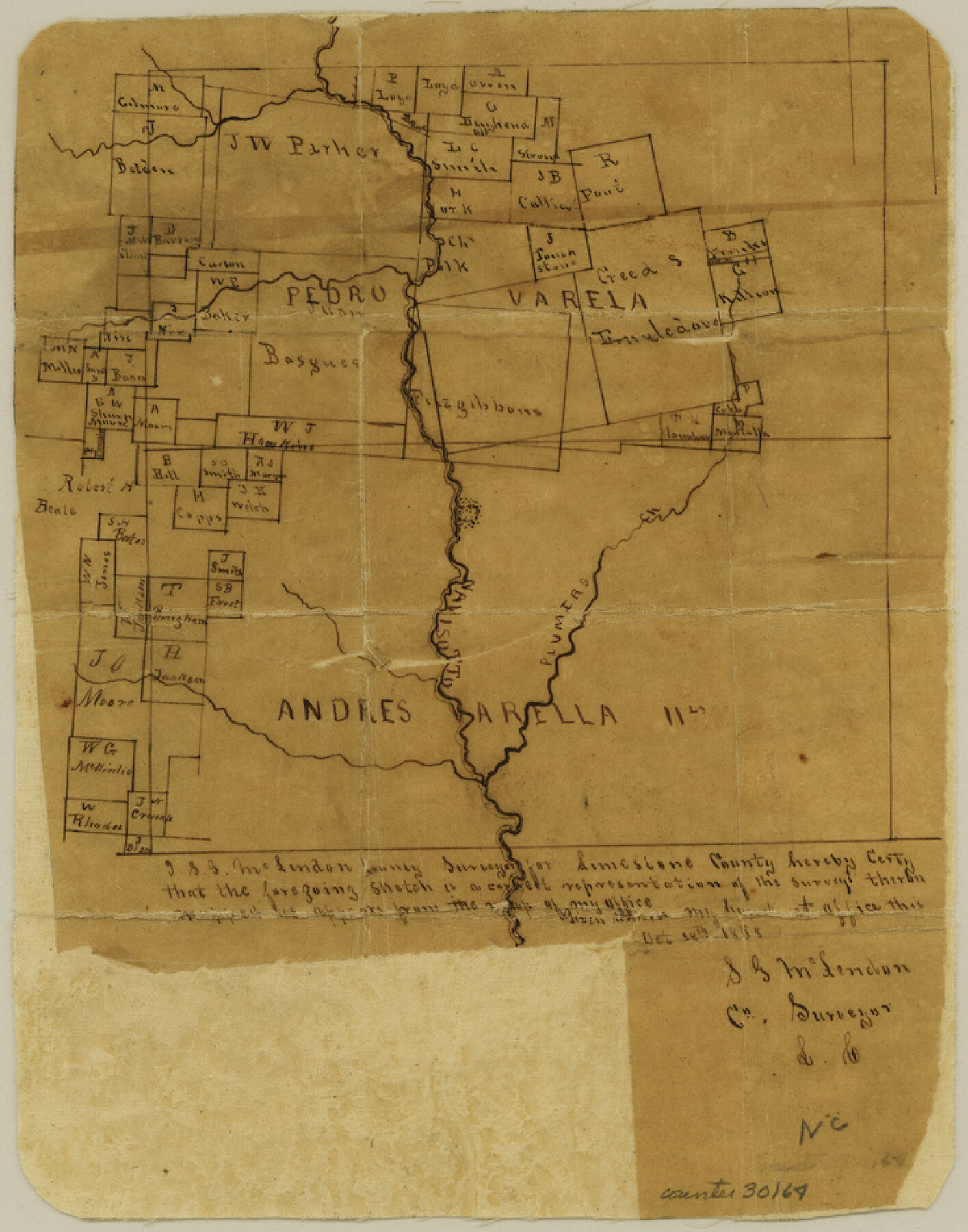
Limestone County Sketch File 5a
[Sketch of Pedro and Andres Varela grants]
-
Map/Doc
30164
-
Collection
General Map Collection
-
Object Dates
10/18/1858 (Creation Date)
-
People and Organizations
S.T. McLendon (Surveyor/Engineer)
-
Counties
Limestone
-
Subjects
Surveying Sketch File
-
Height x Width
9.4 x 7.3 inches
23.9 x 18.5 cm
-
Medium
paper, manuscript
-
Features
Plumirs [sic] Creek
Navisotto [sic] River
Part of: General Map Collection
Hockley County Boundary File 3

Print $12.00
- Digital $50.00
Hockley County Boundary File 3
Size 4.1 x 8.6 inches
Map/Doc 54804
Castro County Sketch File 4l

Print $4.00
- Digital $50.00
Castro County Sketch File 4l
Size 13.5 x 8.6 inches
Map/Doc 17487
Nueces County Sketch File 79

Print $16.00
- Digital $50.00
Nueces County Sketch File 79
Size 11.0 x 8.5 inches
Map/Doc 33096
Webb County Rolled Sketch 32

Print $20.00
- Digital $50.00
Webb County Rolled Sketch 32
1937
Size 24.9 x 21.8 inches
Map/Doc 8188
Hill County Sketch File 8

Print $4.00
- Digital $50.00
Hill County Sketch File 8
1859
Size 10.1 x 8.2 inches
Map/Doc 26472
Presidio County Rolled Sketch 47

Print $20.00
- Digital $50.00
Presidio County Rolled Sketch 47
1908
Size 30.8 x 32.2 inches
Map/Doc 7343
[Missouri, Kansas & Texas Line Map through Bastrop County]
![64028, [Missouri, Kansas & Texas Line Map through Bastrop County], General Map Collection](https://historictexasmaps.com/wmedia_w700/maps/64028.tif.jpg)
Print $40.00
- Digital $50.00
[Missouri, Kansas & Texas Line Map through Bastrop County]
1916
Size 26.2 x 121.8 inches
Map/Doc 64028
Fort Bend County Working Sketch 20

Print $20.00
- Digital $50.00
Fort Bend County Working Sketch 20
1967
Size 22.4 x 33.4 inches
Map/Doc 69226
Flight Mission No. CRC-5R, Frame 16, Chambers County

Print $20.00
- Digital $50.00
Flight Mission No. CRC-5R, Frame 16, Chambers County
1956
Size 18.6 x 22.4 inches
Map/Doc 84938
Colorado County Working Sketch 8

Print $20.00
- Digital $50.00
Colorado County Working Sketch 8
1937
Size 19.7 x 21.0 inches
Map/Doc 68108
Burnet County Sketch File 40

Print $4.00
- Digital $50.00
Burnet County Sketch File 40
Size 14.2 x 8.6 inches
Map/Doc 16755
Flight Mission No. CRC-2R, Frame 2, Chambers County

Print $20.00
- Digital $50.00
Flight Mission No. CRC-2R, Frame 2, Chambers County
1956
Size 18.6 x 22.4 inches
Map/Doc 84721
You may also like
City of San Francisco and its Vicinity, California

Print $20.00
- Digital $50.00
City of San Francisco and its Vicinity, California
1853
Size 28.1 x 20.4 inches
Map/Doc 97233
Concho, San Saba & Llano Valley Railway, Sterling City Branch, Texas. Right of Way and Track Map

Print $40.00
- Digital $50.00
Concho, San Saba & Llano Valley Railway, Sterling City Branch, Texas. Right of Way and Track Map
1910
Size 17.9 x 120.8 inches
Map/Doc 64436
Amistad International Reservoir on Rio Grande 74

Print $20.00
- Digital $50.00
Amistad International Reservoir on Rio Grande 74
1949
Size 28.5 x 40.2 inches
Map/Doc 75501
Gaines County Sketch File 12

Print $4.00
- Digital $50.00
Gaines County Sketch File 12
1950
Size 14.3 x 8.8 inches
Map/Doc 23198
Presidio County Sketch File 52

Print $10.00
- Digital $50.00
Presidio County Sketch File 52
1921
Size 11.5 x 8.8 inches
Map/Doc 34605
Concho County Rolled Sketch 7

Print $20.00
- Digital $50.00
Concho County Rolled Sketch 7
1950
Size 36.9 x 35.7 inches
Map/Doc 8652
Crockett County Working Sketch 64

Print $20.00
- Digital $50.00
Crockett County Working Sketch 64
1957
Size 19.0 x 25.4 inches
Map/Doc 68397
Johnson County Working Sketch 36

Print $20.00
- Digital $50.00
Johnson County Working Sketch 36
2016
Size 24.1 x 36.1 inches
Map/Doc 94088
Rains County Boundary File 2

Print $4.00
- Digital $50.00
Rains County Boundary File 2
Size 8.2 x 5.8 inches
Map/Doc 58092
Flight Mission No. DAG-23K, Frame 145, Matagorda County

Print $20.00
- Digital $50.00
Flight Mission No. DAG-23K, Frame 145, Matagorda County
1953
Size 15.7 x 15.8 inches
Map/Doc 86493
[Sketch for Mineral Application 19144 - Pecos River Bed]
![65574, [Sketch for Mineral Application 19144 - Pecos River Bed], General Map Collection](https://historictexasmaps.com/wmedia_w700/maps/65574.tif.jpg)
Print $20.00
- Digital $50.00
[Sketch for Mineral Application 19144 - Pecos River Bed]
1927
Size 46.2 x 45.1 inches
Map/Doc 65574
[Plat of Victoria, Texas]
![76270, [Plat of Victoria, Texas], Texas State Library and Archives](https://historictexasmaps.com/wmedia_w700/maps/76270.tif.jpg)
Print $20.00
[Plat of Victoria, Texas]
1850
Size 14.1 x 11.5 inches
Map/Doc 76270