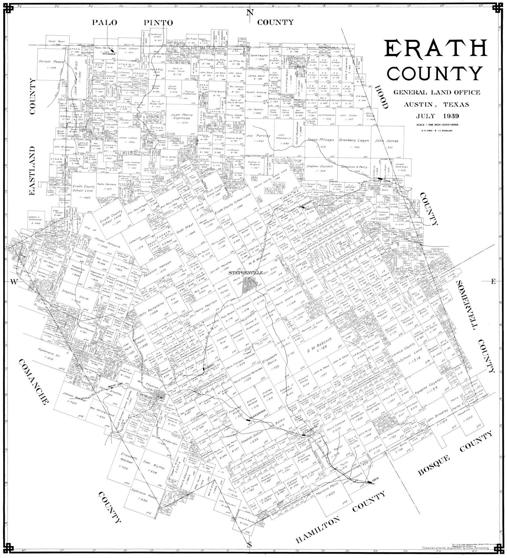
Erath County
-
Map/Doc
77275
-
Collection
General Map Collection
-
Object Dates
1939 (Creation Date)
-
People and Organizations
Eltea Armstrong (Draftsman)
J.L. Woodland (Compiler)
W.S. Vines (Compiler)
-
Counties
Erath
-
Subjects
County
-
Height x Width
45.1 x 41.1 inches
114.6 x 104.4 cm
Part of: General Map Collection
Nueces County Rolled Sketch 52

Print $20.00
- Digital $50.00
Nueces County Rolled Sketch 52
1938
Size 31.3 x 31.7 inches
Map/Doc 9606
Jim Hogg County Rolled Sketch 7

Print $20.00
- Digital $50.00
Jim Hogg County Rolled Sketch 7
1948
Size 32.5 x 28.2 inches
Map/Doc 6442
[Surveys in Austin's Colony by Horatio Chriesman along Mill and Cummins Creeks]
![68, [Surveys in Austin's Colony by Horatio Chriesman along Mill and Cummins Creeks], General Map Collection](https://historictexasmaps.com/wmedia_w700/maps/68.tif.jpg)
Print $20.00
- Digital $50.00
[Surveys in Austin's Colony by Horatio Chriesman along Mill and Cummins Creeks]
1830
Size 30.7 x 25.7 inches
Map/Doc 68
Township 6 North Range 13 West, North Western District, Louisiana

Print $20.00
- Digital $50.00
Township 6 North Range 13 West, North Western District, Louisiana
1841
Size 19.7 x 24.8 inches
Map/Doc 65864
Jefferson County Working Sketch 22

Print $20.00
- Digital $50.00
Jefferson County Working Sketch 22
1969
Size 22.2 x 38.0 inches
Map/Doc 66565
Zavalla County

Print $20.00
- Digital $50.00
Zavalla County
1879
Size 22.8 x 27.2 inches
Map/Doc 4182
Sutton County Working Sketch 22

Print $20.00
- Digital $50.00
Sutton County Working Sketch 22
1981
Size 33.7 x 33.4 inches
Map/Doc 62365
Zapata County Rolled Sketch 22

Print $20.00
- Digital $50.00
Zapata County Rolled Sketch 22
1958
Size 29.2 x 21.5 inches
Map/Doc 8317
La Salle County Rolled Sketch 6A

Print $40.00
- Digital $50.00
La Salle County Rolled Sketch 6A
1941
Size 46.0 x 69.8 inches
Map/Doc 10724
Eastham State Farm - Houston, Walker Counties and Ferguson State Farm, Madison County

Print $20.00
- Digital $50.00
Eastham State Farm - Houston, Walker Counties and Ferguson State Farm, Madison County
Size 27.7 x 40.3 inches
Map/Doc 62975
Presidio County Working Sketch Graphic Index, West Part, Sheet 2 (Sketches 75 to Most Recent)

Print $20.00
- Digital $50.00
Presidio County Working Sketch Graphic Index, West Part, Sheet 2 (Sketches 75 to Most Recent)
1974
Size 40.7 x 31.9 inches
Map/Doc 76673
Ector County Working Sketch 14

Print $40.00
- Digital $50.00
Ector County Working Sketch 14
1955
Size 72.7 x 43.4 inches
Map/Doc 68857
You may also like
Official Map of the State of Texas to accompany the Statistical and Descriptive Work, "Resources, Soil and Climate of Texas"

Print $20.00
Official Map of the State of Texas to accompany the Statistical and Descriptive Work, "Resources, Soil and Climate of Texas"
1882
Size 32.3 x 34.4 inches
Map/Doc 76257
Red River County Working Sketch 13

Print $20.00
- Digital $50.00
Red River County Working Sketch 13
1947
Size 37.1 x 39.9 inches
Map/Doc 71996
Tarrant County

Print $20.00
- Digital $50.00
Tarrant County
1885
Size 36.6 x 36.4 inches
Map/Doc 63056
Flight Mission No. DQN-6K, Frame 13, Calhoun County

Print $20.00
- Digital $50.00
Flight Mission No. DQN-6K, Frame 13, Calhoun County
1953
Size 18.5 x 22.2 inches
Map/Doc 84435
Howard County Sketch File 14

Print $8.00
- Digital $50.00
Howard County Sketch File 14
1940
Size 11.3 x 8.8 inches
Map/Doc 26871
[North Part of Block G]
![92637, [North Part of Block G], Twichell Survey Records](https://historictexasmaps.com/wmedia_w700/maps/92637-1.tif.jpg)
Print $20.00
- Digital $50.00
[North Part of Block G]
Size 24.1 x 19.7 inches
Map/Doc 92637
Map of Calhoun County Texas

Print $20.00
- Digital $50.00
Map of Calhoun County Texas
1911
Size 27.7 x 34.3 inches
Map/Doc 4514
Aransas County Rolled Sketch 11

Print $20.00
- Digital $50.00
Aransas County Rolled Sketch 11
Size 42.0 x 36.4 inches
Map/Doc 8410
Atascosa County Sketch File 2a

Print $40.00
- Digital $50.00
Atascosa County Sketch File 2a
Size 25.1 x 15.3 inches
Map/Doc 10858
San Patricio County Rolled Sketch 17A

Print $20.00
- Digital $50.00
San Patricio County Rolled Sketch 17A
1917
Size 15.7 x 23.8 inches
Map/Doc 7575
Foard County Working Sketch 14

Print $20.00
- Digital $50.00
Foard County Working Sketch 14
1982
Size 37.6 x 46.9 inches
Map/Doc 69205
Upton County Rolled Sketch 58

Print $20.00
- Digital $50.00
Upton County Rolled Sketch 58
Size 39.0 x 35.0 inches
Map/Doc 46125