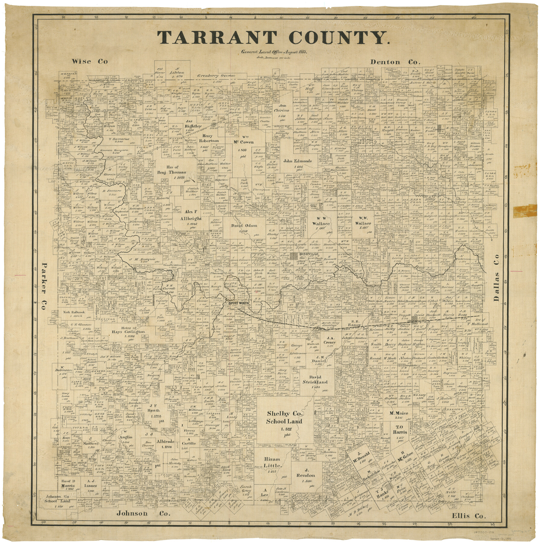
Tarrant County
-
Map/Doc
63056
-
Collection
General Map Collection
-
Object Dates
8/1885 (Creation Date)
-
Counties
Tarrant
-
Subjects
County
-
Height x Width
36.6 x 36.4 inches
93.0 x 92.5 cm
Part of: General Map Collection
Bexar County Working Sketch 3

Print $20.00
- Digital $50.00
Bexar County Working Sketch 3
1941
Size 19.6 x 21.6 inches
Map/Doc 67319
Upton County Working Sketch 39

Print $20.00
- Digital $50.00
Upton County Working Sketch 39
1958
Size 25.4 x 30.1 inches
Map/Doc 69535
North America in the Age of Dinosaurs

North America in the Age of Dinosaurs
1993
Size 27.4 x 20.8 inches
Map/Doc 96831
Map of Galveston County

Print $20.00
- Digital $50.00
Map of Galveston County
1864
Size 19.6 x 28.0 inches
Map/Doc 3576
Sutton County Sketch File 55

Print $24.00
- Digital $50.00
Sutton County Sketch File 55
1952
Size 11.3 x 8.8 inches
Map/Doc 37536
Map of Shackelford County

Print $20.00
- Digital $50.00
Map of Shackelford County
1895
Size 24.1 x 19.5 inches
Map/Doc 4026
Haskell County Sketch File 1

Print $20.00
- Digital $50.00
Haskell County Sketch File 1
1856
Size 19.9 x 10.6 inches
Map/Doc 11738
Wichita County Rolled Sketch 2

Print $20.00
- Digital $50.00
Wichita County Rolled Sketch 2
1879
Size 20.6 x 26.3 inches
Map/Doc 78471
[Pecos and Northern Texas Ry., Bailey Co., from Parmer Co. line through Lariat and Muleshoe to Lamb Co. line]
![64636, [Pecos and Northern Texas Ry., Bailey Co., from Parmer Co. line through Lariat and Muleshoe to Lamb Co. line], General Map Collection](https://historictexasmaps.com/wmedia_w700/maps/64636.tif.jpg)
Print $40.00
- Digital $50.00
[Pecos and Northern Texas Ry., Bailey Co., from Parmer Co. line through Lariat and Muleshoe to Lamb Co. line]
1912
Size 20.3 x 121.9 inches
Map/Doc 64636
Liberty County Working Sketch 14

Print $20.00
- Digital $50.00
Liberty County Working Sketch 14
1919
Size 17.0 x 25.4 inches
Map/Doc 70473
Kaufman County Boundary File 4

Print $52.00
- Digital $50.00
Kaufman County Boundary File 4
Size 7.6 x 8.7 inches
Map/Doc 55934
Map of Bexar County

Print $20.00
- Digital $50.00
Map of Bexar County
1896
Size 46.2 x 39.9 inches
Map/Doc 4766
You may also like
Victoria County

Print $20.00
- Digital $50.00
Victoria County
1858
Size 26.5 x 29.2 inches
Map/Doc 4115
Mileage Map of the Transcontinental Trails of the United States showing best roads, road distances, principal cities

Print $20.00
- Digital $50.00
Mileage Map of the Transcontinental Trails of the United States showing best roads, road distances, principal cities
1920
Size 10.8 x 12.8 inches
Map/Doc 95899
General Highway Map, Jasper County, Newton County, Texas

Print $20.00
General Highway Map, Jasper County, Newton County, Texas
1940
Size 18.6 x 25.2 inches
Map/Doc 79142
Edwards County Working Sketch 40

Print $20.00
- Digital $50.00
Edwards County Working Sketch 40
1949
Size 19.8 x 18.6 inches
Map/Doc 68916
Ector County Working Sketch 7

Print $40.00
- Digital $50.00
Ector County Working Sketch 7
1941
Size 48.5 x 29.3 inches
Map/Doc 68850
Red River County Sketch File 20

Print $4.00
- Digital $50.00
Red River County Sketch File 20
Size 8.2 x 10.1 inches
Map/Doc 35152
Flight Mission No. CRC-2R, Frame 199, Chambers County

Print $20.00
- Digital $50.00
Flight Mission No. CRC-2R, Frame 199, Chambers County
1956
Size 18.6 x 22.4 inches
Map/Doc 84777
Coke County Rolled Sketch 4

Print $20.00
- Digital $50.00
Coke County Rolled Sketch 4
Size 44.6 x 37.0 inches
Map/Doc 8624
Brewster County Rolled Sketch 154

Print $20.00
- Digital $50.00
Brewster County Rolled Sketch 154
2001
Size 36.3 x 28.0 inches
Map/Doc 5325
[Surveys along Red River in Hartley County]
![90739, [Surveys along Red River in Hartley County], Twichell Survey Records](https://historictexasmaps.com/wmedia_w700/maps/90739-1.tif.jpg)
Print $20.00
- Digital $50.00
[Surveys along Red River in Hartley County]
Size 22.0 x 16.7 inches
Map/Doc 90739
McLennan County Sketch File 4

Print $4.00
- Digital $50.00
McLennan County Sketch File 4
1852
Size 12.7 x 8.2 inches
Map/Doc 31235
Record of Spanish Titles, Vol. I

Record of Spanish Titles, Vol. I
1845
Size 19.2 x 13.9 inches
Map/Doc 94526