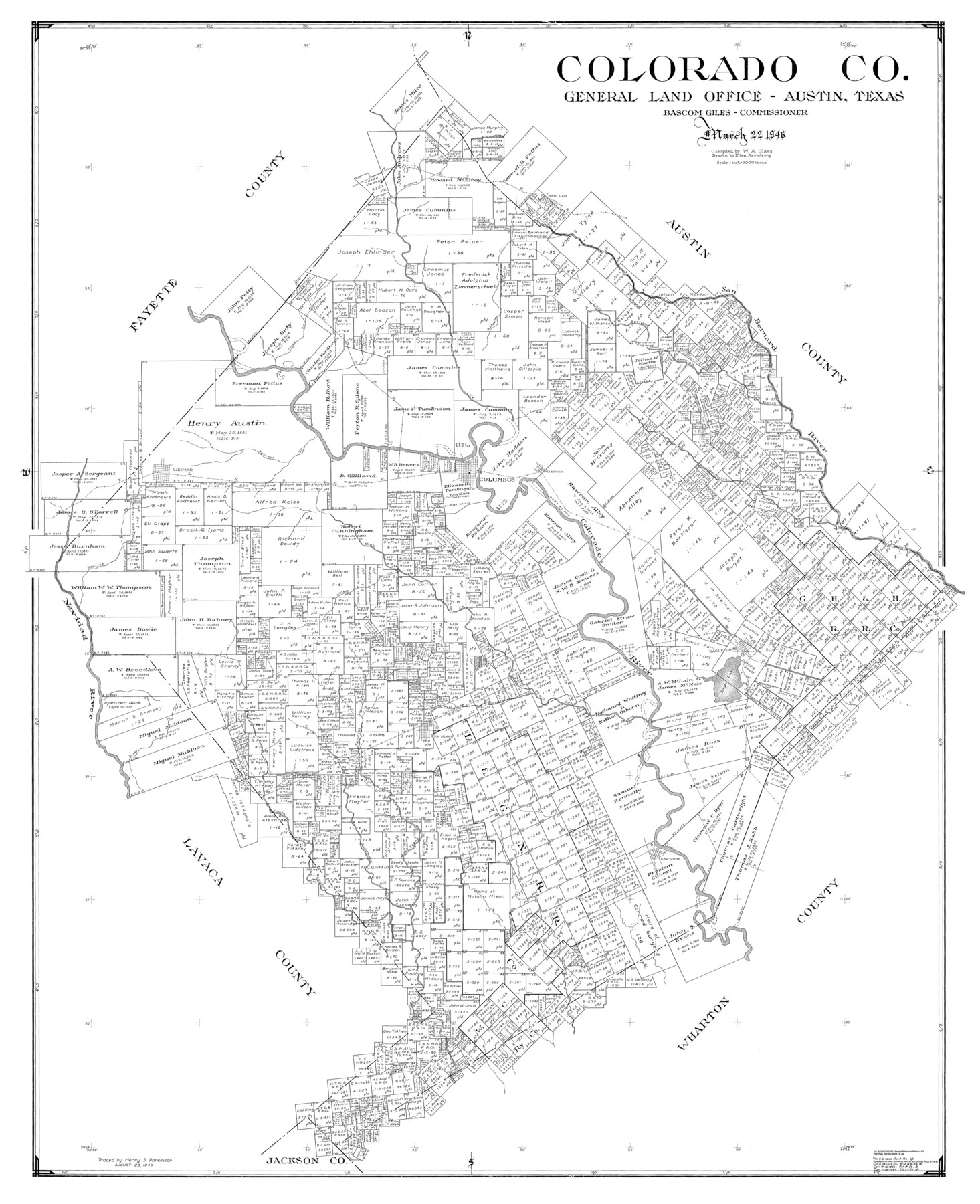
Colorado Co.
-
Map/Doc
77244
-
Collection
General Map Collection
-
Object Dates
1946/3/22 (Creation Date)
-
People and Organizations
Eltea Armstrong (Draftsman)
W.A. Glass (Compiler)
-
Counties
Colorado
-
Subjects
County
-
Height x Width
53.4 x 42.0 inches
135.6 x 106.7 cm
Part of: General Map Collection
Pecos County Rolled Sketch 77

Print $20.00
- Digital $50.00
Pecos County Rolled Sketch 77
1930
Size 38.4 x 23.4 inches
Map/Doc 7238
Refugio County Sketch File 25

Print $6.00
- Digital $50.00
Refugio County Sketch File 25
1915
Size 14.5 x 6.4 inches
Map/Doc 35289
[Sketch for Mineral Application 33721 - 33725 Incl. - Padre and Mustang Island]
![2877, [Sketch for Mineral Application 33721 - 33725 Incl. - Padre and Mustang Island], General Map Collection](https://historictexasmaps.com/wmedia_w700/maps/2877.tif.jpg)
Print $20.00
- Digital $50.00
[Sketch for Mineral Application 33721 - 33725 Incl. - Padre and Mustang Island]
1942
Size 29.8 x 22.6 inches
Map/Doc 2877
Trinity County Sketch File 25

Print $20.00
- Digital $50.00
Trinity County Sketch File 25
Size 19.5 x 37.3 inches
Map/Doc 12487
Hockley County

Print $20.00
- Digital $50.00
Hockley County
1954
Size 41.0 x 36.4 inches
Map/Doc 77313

Lynn County Rolled Sketch W

Print $20.00
- Digital $50.00
Lynn County Rolled Sketch W
Size 23.0 x 40.0 inches
Map/Doc 6655
[F. W. & D. C. Ry. Co. Alignment and Right of Way Map, Clay County]
![64723, [F. W. & D. C. Ry. Co. Alignment and Right of Way Map, Clay County], General Map Collection](https://historictexasmaps.com/wmedia_w700/maps/64723-1.tif.jpg)
Print $20.00
- Digital $50.00
[F. W. & D. C. Ry. Co. Alignment and Right of Way Map, Clay County]
1927
Size 18.6 x 11.8 inches
Map/Doc 64723
Webb County Sketch File 19

Print $15.00
- Digital $50.00
Webb County Sketch File 19
1902
Size 9.2 x 17.0 inches
Map/Doc 39822
San Jacinto County Working Sketch 27

Print $20.00
- Digital $50.00
San Jacinto County Working Sketch 27
1944
Size 30.5 x 23.3 inches
Map/Doc 63740
Coast Chart No. 106 - Oyster Bay to Matagorda Bay, Texas

Print $20.00
- Digital $50.00
Coast Chart No. 106 - Oyster Bay to Matagorda Bay, Texas
1878
Size 24.7 x 30.0 inches
Map/Doc 69928
Cass County Working Sketch 22

Print $20.00
- Digital $50.00
Cass County Working Sketch 22
1961
Size 21.7 x 34.0 inches
Map/Doc 67925
You may also like
Blanco River, Austin Girl Scouts Council

Print $6.00
- Digital $50.00
Blanco River, Austin Girl Scouts Council
1938
Size 18.5 x 31.6 inches
Map/Doc 65058
Hamilton County Sketch File 15

Print $2.00
- Digital $50.00
Hamilton County Sketch File 15
1882
Size 8.0 x 11.8 inches
Map/Doc 24941
[Blocks 341, G-5, G-12, TCRRCo.]
![60298, [Blocks 341, G-5, G-12, TCRRCo.], General Map Collection](https://historictexasmaps.com/wmedia_w700/maps/60298-1.tif.jpg)
Print $20.00
- Digital $50.00
[Blocks 341, G-5, G-12, TCRRCo.]
1954
Size 15.1 x 26.1 inches
Map/Doc 60298
Pecos County Rolled Sketch 22

Print $40.00
- Digital $50.00
Pecos County Rolled Sketch 22
1886
Size 73.4 x 45.2 inches
Map/Doc 93461
Loving County Rolled Sketch 1A

Print $40.00
- Digital $50.00
Loving County Rolled Sketch 1A
Size 77.9 x 42.9 inches
Map/Doc 9461
DeWitt County Working Sketch 10

Print $20.00
- Digital $50.00
DeWitt County Working Sketch 10
1980
Size 15.1 x 12.0 inches
Map/Doc 68600
Hill County Sketch File 1

Print $4.00
- Digital $50.00
Hill County Sketch File 1
1857
Size 9.0 x 7.9 inches
Map/Doc 26459
Mills County Sketch File 22

Print $4.00
- Digital $50.00
Mills County Sketch File 22
1882
Size 9.8 x 8.0 inches
Map/Doc 31670
Kent County Boundary File 2

Print $4.00
- Digital $50.00
Kent County Boundary File 2
Size 10.1 x 8.2 inches
Map/Doc 55822
Shelby County Rolled Sketch 9

Print $20.00
- Digital $50.00
Shelby County Rolled Sketch 9
Size 23.0 x 19.1 inches
Map/Doc 7777
Map of San Antonio Showing Original Townsite in Relation to Mission Valero

Map of San Antonio Showing Original Townsite in Relation to Mission Valero
2017
Size 11.0 x 8.5 inches
Map/Doc 94244
Liberty County Rolled Sketch 12

Print $20.00
- Digital $50.00
Liberty County Rolled Sketch 12
1983
Size 26.5 x 22.6 inches
Map/Doc 6618