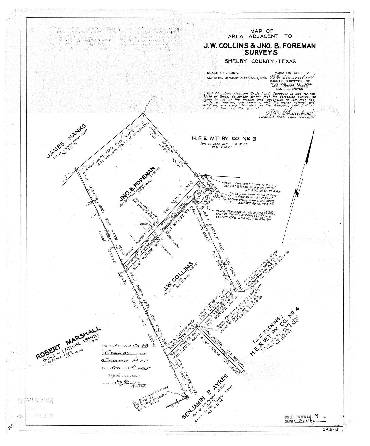
Shelby County Rolled Sketch 9
Map of area adjacent to J.W. Collins & Jno. B. Foreman surveys, Shelby County, Texas
-
Map/Doc
7777
-
Collection
General Map Collection
-
Object Dates
1945 (Survey Date)
1945/4/13 (File Date)
-
People and Organizations
W.B. Chambers (Surveyor/Engineer)
-
Counties
Shelby
-
Subjects
Surveying Rolled Sketch
-
Height x Width
23.0 x 19.1 inches
58.4 x 48.5 cm
-
Scale
1" = 200 varas
Part of: General Map Collection
Flight Mission No. DQN-1K, Frame 82, Calhoun County

Print $20.00
- Digital $50.00
Flight Mission No. DQN-1K, Frame 82, Calhoun County
1953
Size 18.5 x 22.2 inches
Map/Doc 84167
Flight Mission No. CRC-2R, Frame 133, Chambers County

Print $20.00
- Digital $50.00
Flight Mission No. CRC-2R, Frame 133, Chambers County
1956
Size 18.7 x 22.5 inches
Map/Doc 84749
South Part of El Paso Co.

Print $20.00
- Digital $50.00
South Part of El Paso Co.
1977
Size 30.5 x 40.8 inches
Map/Doc 77274
Lamb County Boundary File 1e

Print $10.00
- Digital $50.00
Lamb County Boundary File 1e
Size 11.3 x 8.8 inches
Map/Doc 56053
Upton County Sketch File 28

Print $5.00
- Digital $50.00
Upton County Sketch File 28
1929
Size 22.8 x 31.8 inches
Map/Doc 12521
Flight Mission No. CUG-2P, Frame 79, Kleberg County

Print $20.00
- Digital $50.00
Flight Mission No. CUG-2P, Frame 79, Kleberg County
1956
Size 18.4 x 22.1 inches
Map/Doc 86211
Brewster County Rolled Sketch 103

Print $40.00
- Digital $50.00
Brewster County Rolled Sketch 103
1955
Size 51.8 x 27.9 inches
Map/Doc 5256
Flight Mission No. DQN-3K, Frame 68, Calhoun County

Print $20.00
- Digital $50.00
Flight Mission No. DQN-3K, Frame 68, Calhoun County
1953
Size 18.5 x 22.3 inches
Map/Doc 84359
San Jacinto County Working Sketch 6

Print $20.00
- Digital $50.00
San Jacinto County Working Sketch 6
1934
Size 37.1 x 42.5 inches
Map/Doc 63719
Kinney County Sketch File 32

Print $6.00
- Digital $50.00
Kinney County Sketch File 32
1934
Size 11.2 x 8.8 inches
Map/Doc 29178
Van Zandt County Sketch File 20a

Print $4.00
- Digital $50.00
Van Zandt County Sketch File 20a
1858
Size 12.9 x 8.0 inches
Map/Doc 39428
Brewster County Working Sketch 71b

Print $40.00
- Digital $50.00
Brewster County Working Sketch 71b
1961
Size 50.6 x 55.0 inches
Map/Doc 67870
You may also like
Nueces County Rolled Sketch 74

Print $32.00
Nueces County Rolled Sketch 74
1981
Size 18.4 x 25.3 inches
Map/Doc 6932
Map of Hale County, Texas

Print $2.00
- Digital $50.00
Map of Hale County, Texas
Size 8.8 x 11.2 inches
Map/Doc 90697
Kerr County Working Sketch 28

Print $20.00
- Digital $50.00
Kerr County Working Sketch 28
1971
Size 38.5 x 39.1 inches
Map/Doc 70059
Wheeler County Boundary File 1b

Print $2.00
- Digital $50.00
Wheeler County Boundary File 1b
Size 12.3 x 8.8 inches
Map/Doc 59869
Nueces County Rolled Sketch 115

Print $215.00
Nueces County Rolled Sketch 115
1992
Size 24.2 x 35.2 inches
Map/Doc 7126
[Galveston, Harrisburg & San Antonio through El Paso County]
![64006, [Galveston, Harrisburg & San Antonio through El Paso County], General Map Collection](https://historictexasmaps.com/wmedia_w700/maps/64006.tif.jpg)
Print $20.00
- Digital $50.00
[Galveston, Harrisburg & San Antonio through El Paso County]
Size 13.5 x 33.7 inches
Map/Doc 64006
General Highway Map, Glasscock County, Texas

Print $20.00
General Highway Map, Glasscock County, Texas
1940
Size 18.5 x 25.2 inches
Map/Doc 79100

[Worksheets related to the Wilson Strickland survey and vicinity]
![91349, [Worksheets related to the Wilson Strickland survey and vicinity], Twichell Survey Records](https://historictexasmaps.com/wmedia_w700/maps/91349-1.tif.jpg)
Print $20.00
- Digital $50.00
[Worksheets related to the Wilson Strickland survey and vicinity]
Size 22.9 x 13.8 inches
Map/Doc 91349
Childress County Rolled Sketch 19

Print $20.00
- Digital $50.00
Childress County Rolled Sketch 19
2004
Size 24.6 x 18.6 inches
Map/Doc 81937
Text (Possibly Legislative) Describing the Boundaries of Washington County, Undated

Print $20.00
Text (Possibly Legislative) Describing the Boundaries of Washington County, Undated
2020
Size 20.0 x 21.7 inches
Map/Doc 96407
Baylor County Boundary File 13

Print $44.00
- Digital $50.00
Baylor County Boundary File 13
Size 4.3 x 9.7 inches
Map/Doc 50424