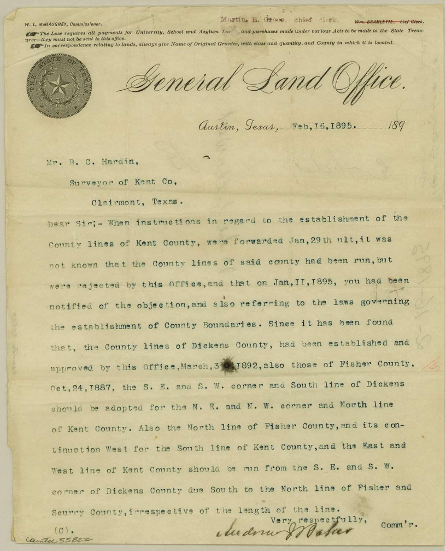
Kent County Boundary File 2
[Letter regarding Kent Boundary lines]
-
Map/Doc
55822
-
Collection
General Map Collection
-
Counties
Kent
-
Subjects
County Boundaries
-
Height x Width
10.1 x 8.2 inches
25.7 x 20.8 cm
Part of: General Map Collection
Nacogdoches County Sketch File 5

Print $4.00
- Digital $50.00
Nacogdoches County Sketch File 5
1859
Size 12.6 x 8.1 inches
Map/Doc 32243
Bandera County Working Sketch 43

Print $20.00
- Digital $50.00
Bandera County Working Sketch 43
1978
Size 27.7 x 31.6 inches
Map/Doc 67639
Cass County Working Sketch 32

Print $20.00
- Digital $50.00
Cass County Working Sketch 32
1982
Size 24.0 x 22.6 inches
Map/Doc 67935
Jack County Sketch File 4

Print $4.00
- Digital $50.00
Jack County Sketch File 4
1857
Size 9.0 x 12.7 inches
Map/Doc 27506
Irion County Sketch File 8

Print $6.00
- Digital $50.00
Irion County Sketch File 8
Size 14.5 x 9.8 inches
Map/Doc 27473
Map of Nolan County

Print $20.00
- Digital $50.00
Map of Nolan County
1902
Size 45.9 x 38.4 inches
Map/Doc 16780
Flight Mission No. BRA-16M, Frame 123, Jefferson County

Print $20.00
- Digital $50.00
Flight Mission No. BRA-16M, Frame 123, Jefferson County
1953
Size 18.6 x 22.5 inches
Map/Doc 85733
Reeves County Rolled Sketch 37

Print $20.00
- Digital $50.00
Reeves County Rolled Sketch 37
2017
Size 22.9 x 17.1 inches
Map/Doc 95203
Milam County Boundary File 4

Print $4.00
- Digital $50.00
Milam County Boundary File 4
Size 13.3 x 8.2 inches
Map/Doc 57221
Acreage in Texas Counties

Print $20.00
- Digital $50.00
Acreage in Texas Counties
1966
Size 47.1 x 25.8 inches
Map/Doc 73594
Gonzales County

Print $40.00
- Digital $50.00
Gonzales County
1986
Size 41.6 x 54.7 inches
Map/Doc 73160
Webb County Sketch File 13b

Print $3.00
- Digital $50.00
Webb County Sketch File 13b
1893
Size 14.0 x 9.8 inches
Map/Doc 39803
You may also like
Foard County Working Sketch 10

Print $20.00
- Digital $50.00
Foard County Working Sketch 10
1977
Size 32.0 x 43.7 inches
Map/Doc 69201
Angelina County Sketch File 5

Print $6.00
- Digital $50.00
Angelina County Sketch File 5
1854
Size 8.6 x 6.6 inches
Map/Doc 12928
Harris County Sketch File 110

Print $26.00
- Digital $50.00
Harris County Sketch File 110
2009
Size 11.0 x 8.5 inches
Map/Doc 89586
Trinity County Sketch File 14

Print $4.00
- Digital $50.00
Trinity County Sketch File 14
1862
Size 8.7 x 12.0 inches
Map/Doc 38540
Ward County Working Sketch 15

Print $20.00
- Digital $50.00
Ward County Working Sketch 15
1947
Size 38.7 x 40.4 inches
Map/Doc 72321
Wichita County Working Sketch 1

Print $20.00
- Digital $50.00
Wichita County Working Sketch 1
Size 23.5 x 24.2 inches
Map/Doc 72510

Callahan County

Print $20.00
- Digital $50.00
Callahan County
1918
Size 45.5 x 40.3 inches
Map/Doc 4787
Flight Mission No. DIX-3P, Frame 165, Aransas County

Print $20.00
- Digital $50.00
Flight Mission No. DIX-3P, Frame 165, Aransas County
1956
Size 17.8 x 18.4 inches
Map/Doc 83771
Galveston County NRC Article 33.136 Location Key Sheet

Print $20.00
- Digital $50.00
Galveston County NRC Article 33.136 Location Key Sheet
1993
Size 27.3 x 23.0 inches
Map/Doc 83000
Newton County Sketch File 41

Print $44.00
- Digital $50.00
Newton County Sketch File 41
1930
Size 11.2 x 8.7 inches
Map/Doc 32421
General Highway Map, Winkler County, Texas

Print $20.00
General Highway Map, Winkler County, Texas
1940
Size 18.4 x 24.7 inches
Map/Doc 79283