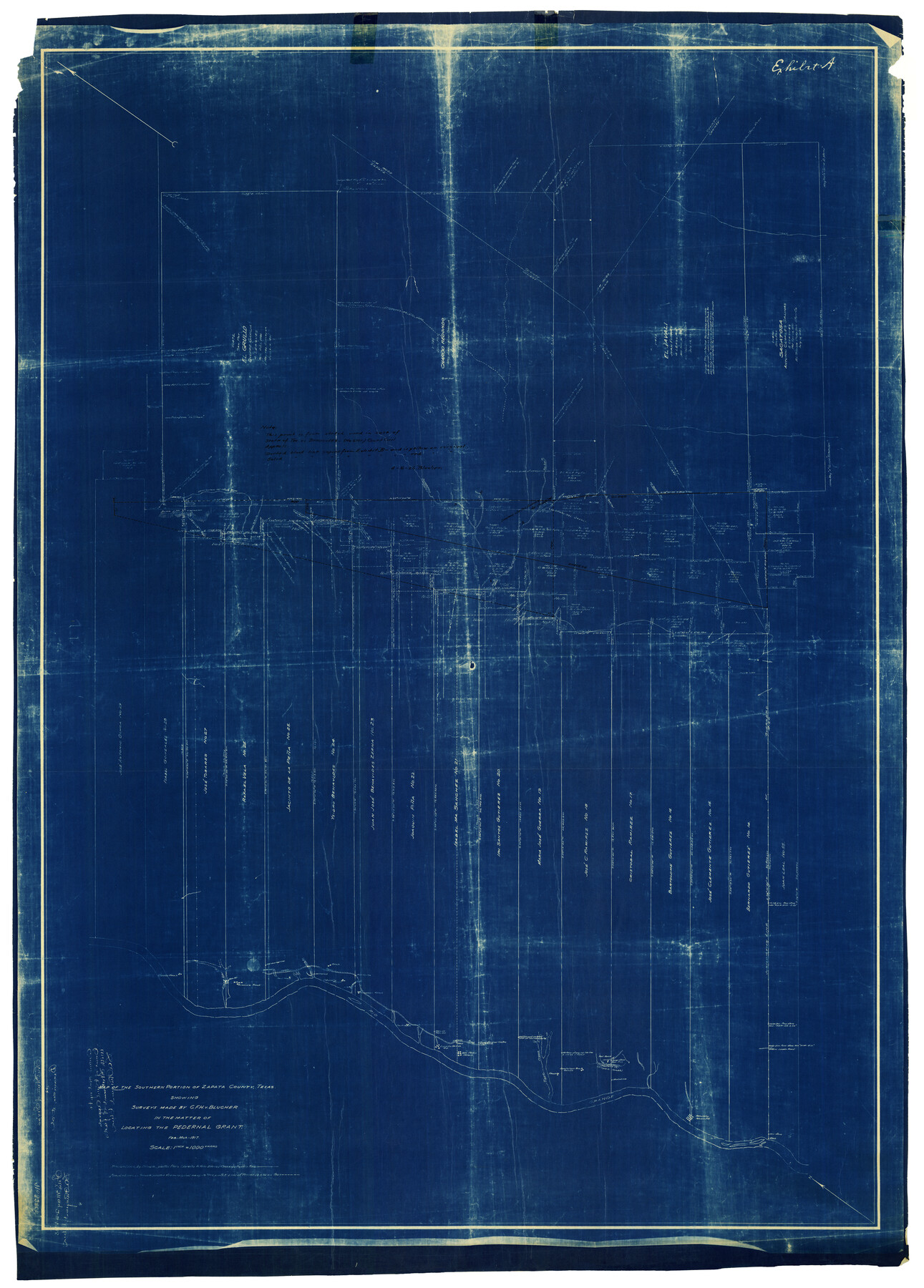
Zapata County Rolled Sketch 12B
Map of the southern portion of Zapata County, Texas showing surveys made by C.F.H. v. Blucher in the matter of locating the Pedernal grant
-
Map/Doc
10166
-
Collection
General Map Collection
-
Object Dates
3/1917 (Creation Date)
-
People and Organizations
C.F.H. von Blucher (Surveyor/Engineer)
-
Counties
Zapata
-
Subjects
Surveying Rolled Sketch
-
Height x Width
55.7 x 40.0 inches
141.5 x 101.6 cm
-
Medium
blueprint/diazo
-
Scale
1" = 1000 varas
Part of: General Map Collection
Comal County Working Sketch 5

Print $20.00
- Digital $50.00
Comal County Working Sketch 5
1950
Size 19.0 x 21.4 inches
Map/Doc 68171
Flight Mission No. DQN-2K, Frame 44, Calhoun County

Print $20.00
- Digital $50.00
Flight Mission No. DQN-2K, Frame 44, Calhoun County
1953
Size 18.4 x 22.1 inches
Map/Doc 84249
Dimmit County Sketch File 2

Print $6.00
- Digital $50.00
Dimmit County Sketch File 2
Size 8.6 x 7.9 inches
Map/Doc 21055
Eastland County Working Sketch 5

Print $20.00
- Digital $50.00
Eastland County Working Sketch 5
1918
Size 16.1 x 19.3 inches
Map/Doc 68786
Goliad County Sketch File 37

Print $4.00
- Digital $50.00
Goliad County Sketch File 37
1850
Size 10.2 x 8.3 inches
Map/Doc 24336
Gregg County Boundary File 4

Print $14.00
- Digital $50.00
Gregg County Boundary File 4
Size 14.1 x 8.6 inches
Map/Doc 53992
Outer Continental Shelf Leasing Maps (Texas Offshore Operations)

Print $20.00
- Digital $50.00
Outer Continental Shelf Leasing Maps (Texas Offshore Operations)
Size 17.7 x 14.3 inches
Map/Doc 75856
Galveston County Working Sketch 23

Print $20.00
- Digital $50.00
Galveston County Working Sketch 23
1988
Size 35.8 x 30.6 inches
Map/Doc 69360
Oldham County Sketch File 13

Print $40.00
- Digital $50.00
Oldham County Sketch File 13
1902
Size 14.3 x 12.3 inches
Map/Doc 33260
Amistad International Reservoir on Rio Grande 70

Print $20.00
- Digital $50.00
Amistad International Reservoir on Rio Grande 70
1949
Size 28.4 x 39.7 inches
Map/Doc 73356
Cameron County Rolled Sketch 30

Print $20.00
- Digital $50.00
Cameron County Rolled Sketch 30
1930
Size 36.3 x 24.4 inches
Map/Doc 5394
Liberty County Working Sketch 77

Print $20.00
- Digital $50.00
Liberty County Working Sketch 77
Size 37.4 x 45.9 inches
Map/Doc 70537
You may also like
Mapa de los Estados Unidos de Méjico, Segun lo organizado y definido por las varias actas del Congreso de dicha Republica: y construido por las mejores autoridades

Print $20.00
Mapa de los Estados Unidos de Méjico, Segun lo organizado y definido por las varias actas del Congreso de dicha Republica: y construido por las mejores autoridades
1828
Size 29.3 x 41.6 inches
Map/Doc 76217
Dickens County Working Sketch 3

Print $20.00
- Digital $50.00
Dickens County Working Sketch 3
Size 17.5 x 15.3 inches
Map/Doc 68650
Baylor County Rolled Sketch 11

Print $20.00
- Digital $50.00
Baylor County Rolled Sketch 11
Size 19.4 x 19.9 inches
Map/Doc 5128
Pecos County Working Sketch 80

Print $20.00
- Digital $50.00
Pecos County Working Sketch 80
1960
Size 25.0 x 31.8 inches
Map/Doc 71552
Andrews County Rolled Sketch 22

Print $20.00
- Digital $50.00
Andrews County Rolled Sketch 22
1946
Size 26.4 x 24.0 inches
Map/Doc 77170
Map of the Houston & Tex. Cen. R.R. from Dallas, Dallas Co., to McKinney, Collin Co.

Print $20.00
- Digital $50.00
Map of the Houston & Tex. Cen. R.R. from Dallas, Dallas Co., to McKinney, Collin Co.
1873
Size 23.0 x 43.8 inches
Map/Doc 64474
Galveston County Rolled Sketch CCW

Print $20.00
- Digital $50.00
Galveston County Rolled Sketch CCW
1938
Size 38.4 x 39.7 inches
Map/Doc 9084
Carson County Boundary File 3

Print $2.00
- Digital $50.00
Carson County Boundary File 3
Size 13.3 x 8.3 inches
Map/Doc 51131
[Northwest Garza County around John Walker and Thomas Hughes surveys]
![90848, [Northwest Garza County around John Walker and Thomas Hughes surveys], Twichell Survey Records](https://historictexasmaps.com/wmedia_w700/maps/90848-2.tif.jpg)
Print $20.00
- Digital $50.00
[Northwest Garza County around John Walker and Thomas Hughes surveys]
1913
Size 27.5 x 14.3 inches
Map/Doc 90848
Zapata County Working Sketch 10

Print $20.00
- Digital $50.00
Zapata County Working Sketch 10
1954
Size 33.9 x 32.2 inches
Map/Doc 62061
Flight Mission No. DQN-2K, Frame 158, Calhoun County

Print $20.00
- Digital $50.00
Flight Mission No. DQN-2K, Frame 158, Calhoun County
1953
Size 18.4 x 22.3 inches
Map/Doc 84320
Smith County Working Sketch Graphic Index

Print $20.00
- Digital $50.00
Smith County Working Sketch Graphic Index
1948
Size 44.7 x 41.1 inches
Map/Doc 76699