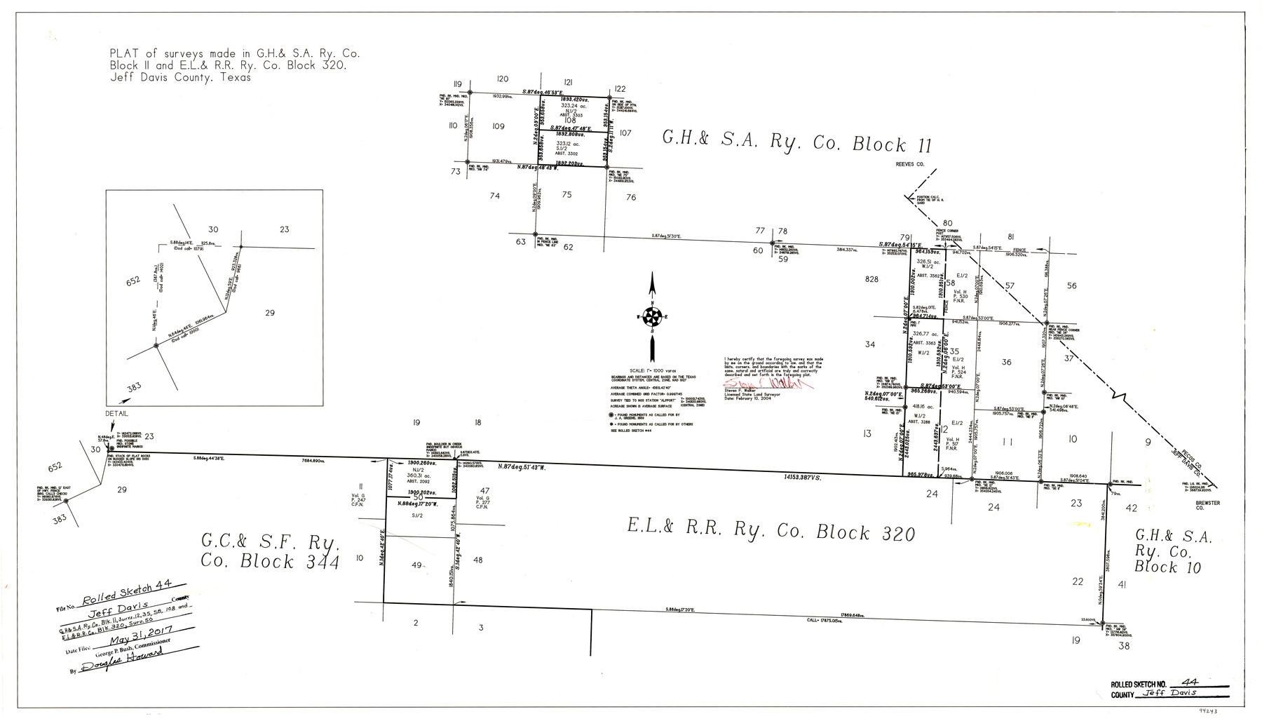
Jeff Davis County Rolled Sketch 44
Plat of surveys made in G. H. & S. A. Ry. Co. Block 11 and E. L. & R. R. Ry. Co. Block 320, Jeff Davis County, Texas
-
Map/Doc
94243
-
Collection
General Map Collection
-
Object Dates
2014/2/10 (Creation Date)
2017/5/31 (File Date)
-
People and Organizations
Steven F. Walker (Surveyor/Engineer)
-
Counties
Jeff Davis
-
Subjects
Surveying Rolled Sketch
-
Height x Width
19.8 x 34.7 inches
50.3 x 88.1 cm
-
Medium
mylar, print
-
Scale
1" = 1000 varas
Part of: General Map Collection
Galveston Bay Entrance - Galveston and Texas City Harbors

Print $40.00
- Digital $50.00
Galveston Bay Entrance - Galveston and Texas City Harbors
1982
Size 37.0 x 53.3 inches
Map/Doc 69865
Louisiana and Texas Intracoastal Waterway - Sabine River-Galveston Bay Section, Steel Sheet Pile Dyke at Galveston Bay Entrance

Print $20.00
- Digital $50.00
Louisiana and Texas Intracoastal Waterway - Sabine River-Galveston Bay Section, Steel Sheet Pile Dyke at Galveston Bay Entrance
1933
Size 31.4 x 40.9 inches
Map/Doc 61818
Presidio County Rolled Sketch 113

Print $20.00
- Digital $50.00
Presidio County Rolled Sketch 113
1978
Size 22.2 x 27.8 inches
Map/Doc 7389
Bexar County Sketch File 25

Print $4.00
- Digital $50.00
Bexar County Sketch File 25
1860
Size 8.9 x 8.7 inches
Map/Doc 14486
Controlled Mosaic by Jack Amman Photogrammetric Engineers, Inc - Sheet 42

Print $20.00
- Digital $50.00
Controlled Mosaic by Jack Amman Photogrammetric Engineers, Inc - Sheet 42
1954
Size 20.0 x 24.0 inches
Map/Doc 83500
Southern Part of Laguna Madre

Print $20.00
- Digital $50.00
Southern Part of Laguna Madre
1952
Size 44.7 x 35.2 inches
Map/Doc 73537
Harris County Sketch File 107

Print $18.00
- Digital $50.00
Harris County Sketch File 107
1996
Size 11.2 x 8.7 inches
Map/Doc 26015
Concho County Sketch File 37

Print $20.00
- Digital $50.00
Concho County Sketch File 37
1938
Size 18.7 x 29.1 inches
Map/Doc 11162
Marion County Working Sketch 13

Print $20.00
- Digital $50.00
Marion County Working Sketch 13
1953
Size 33.2 x 36.3 inches
Map/Doc 70789
Brown County Sketch File 10

Print $40.00
- Digital $50.00
Brown County Sketch File 10
1868
Size 17.4 x 22.3 inches
Map/Doc 11019
Red River, Bois D'Arc Creek Floodway Sheet No. 4

Print $20.00
- Digital $50.00
Red River, Bois D'Arc Creek Floodway Sheet No. 4
1917
Size 20.3 x 28.9 inches
Map/Doc 69659
Coleman County Sketch File 37

Print $4.00
- Digital $50.00
Coleman County Sketch File 37
1891
Size 11.1 x 8.4 inches
Map/Doc 18742
You may also like
Wise County Working Sketch 7

Print $20.00
- Digital $50.00
Wise County Working Sketch 7
1950
Size 26.2 x 24.8 inches
Map/Doc 72621
Right-of-Way and Track Map, Houston and Brazos Valley Ry. Co. operated by the Houston and Brazos Valley Ry. Co.

Print $40.00
- Digital $50.00
Right-of-Way and Track Map, Houston and Brazos Valley Ry. Co. operated by the Houston and Brazos Valley Ry. Co.
1918
Size 24.9 x 56.4 inches
Map/Doc 64602
Brewster County Rolled Sketch 66

Print $20.00
- Digital $50.00
Brewster County Rolled Sketch 66
1946
Size 33.0 x 36.2 inches
Map/Doc 61785
Flight Mission No. DCL-6C, Frame 20, Kenedy County

Print $20.00
- Digital $50.00
Flight Mission No. DCL-6C, Frame 20, Kenedy County
1943
Size 18.7 x 22.4 inches
Map/Doc 85877
Brewster County Rolled Sketch 101

Print $40.00
- Digital $50.00
Brewster County Rolled Sketch 101
1927
Size 74.2 x 42.3 inches
Map/Doc 9192
Coleman County Sketch File 25

Print $40.00
- Digital $50.00
Coleman County Sketch File 25
1872
Size 12.5 x 15.8 inches
Map/Doc 18710
Duval County Sketch File 54

Print $20.00
- Digital $50.00
Duval County Sketch File 54
1937
Size 19.0 x 26.4 inches
Map/Doc 11403
Flight Mission No. BRA-16M, Frame 54, Jefferson County

Print $20.00
- Digital $50.00
Flight Mission No. BRA-16M, Frame 54, Jefferson County
1953
Size 18.5 x 22.5 inches
Map/Doc 85671
Medina County Sketch File 8

Print $4.00
- Digital $50.00
Medina County Sketch File 8
Size 9.3 x 6.6 inches
Map/Doc 31456
History of the Geography of Texas

Print $40.00
- Digital $50.00
History of the Geography of Texas
1897
Size 70.7 x 52.9 inches
Map/Doc 3095
Gonzales County Sketch File 4

Print $4.00
- Digital $50.00
Gonzales County Sketch File 4
Size 12.6 x 8.0 inches
Map/Doc 24373
Harris County Sketch File 17

Print $4.00
- Digital $50.00
Harris County Sketch File 17
1860
Size 5.8 x 5.6 inches
Map/Doc 25361