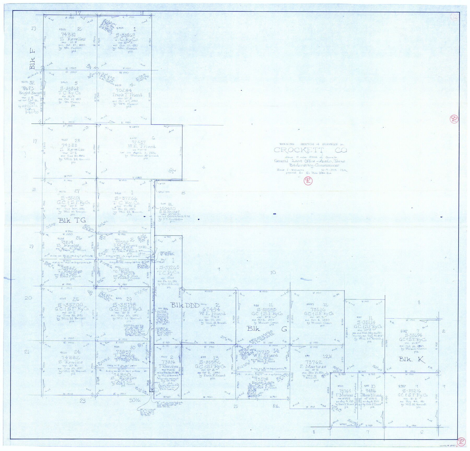
Crockett County Working Sketch 92
-
Map/Doc
68425
-
Collection
General Map Collection
-
Object Dates
12/7/1978 (Creation Date)
-
People and Organizations
Joan Kilpatrick (Draftsman)
-
Counties
Crockett
-
Subjects
Surveying Working Sketch
-
Height x Width
39.5 x 41.2 inches
100.3 x 104.7 cm
-
Scale
1" = 400 varas
Part of: General Map Collection
Grayson County Working Sketch 1

Print $20.00
- Digital $50.00
Grayson County Working Sketch 1
1939
Size 10.8 x 17.7 inches
Map/Doc 63240
Orange County Sketch File 27

Print $20.00
- Digital $50.00
Orange County Sketch File 27
1915
Size 18.6 x 21.8 inches
Map/Doc 12123
Brazoria County Sketch File 55

Print $80.00
- Digital $50.00
Brazoria County Sketch File 55
1899
Size 14.9 x 55.0 inches
Map/Doc 10327
Ellis County Sketch File 10

Print $40.00
- Digital $50.00
Ellis County Sketch File 10
1860
Size 12.7 x 16.1 inches
Map/Doc 21845
Flight Mission No. CGI-1N, Frame 214, Cameron County

Print $20.00
- Digital $50.00
Flight Mission No. CGI-1N, Frame 214, Cameron County
1955
Size 18.5 x 22.1 inches
Map/Doc 84523
Angelina County Sketch File 15d

Print $20.00
- Digital $50.00
Angelina County Sketch File 15d
1863
Size 8.0 x 6.6 inches
Map/Doc 12980
Matagorda County NRC Article 33.136 Location Key Sheet

Print $20.00
- Digital $50.00
Matagorda County NRC Article 33.136 Location Key Sheet
1995
Size 27.0 x 23.0 inches
Map/Doc 87910
Sulphur River, Dunbar Creek Sheet

Print $4.00
- Digital $50.00
Sulphur River, Dunbar Creek Sheet
1941
Size 17.2 x 20.9 inches
Map/Doc 65174
Val Verde County Working Sketch 118

Print $40.00
- Digital $50.00
Val Verde County Working Sketch 118
2005
Size 29.6 x 50.0 inches
Map/Doc 83587
Baylor County Sketch File 12A

Print $8.00
- Digital $50.00
Baylor County Sketch File 12A
1900
Size 9.3 x 7.3 inches
Map/Doc 14148
Lynn County Rolled Sketch 13

Print $20.00
- Digital $50.00
Lynn County Rolled Sketch 13
1926
Size 18.6 x 24.4 inches
Map/Doc 6650
Flight Mission No. DIX-8P, Frame 82, Aransas County

Print $20.00
- Digital $50.00
Flight Mission No. DIX-8P, Frame 82, Aransas County
1956
Size 18.6 x 22.4 inches
Map/Doc 83907
You may also like
[Leagues 116 through 161, Leagues 165, 181, and 182]
![92484, [Leagues 116 through 161, Leagues 165, 181, and 182], Twichell Survey Records](https://historictexasmaps.com/wmedia_w700/maps/92484-1.tif.jpg)
Print $20.00
- Digital $50.00
[Leagues 116 through 161, Leagues 165, 181, and 182]
Size 17.8 x 23.7 inches
Map/Doc 92484
Sutton County Rolled Sketch 68

Print $20.00
- Digital $50.00
Sutton County Rolled Sketch 68
Size 31.0 x 37.4 inches
Map/Doc 9980
Pecos County Sketch File 48

Print $4.00
- Digital $50.00
Pecos County Sketch File 48
1935
Size 14.3 x 8.8 inches
Map/Doc 33762
Archer County Working Sketch 4

Print $40.00
- Digital $50.00
Archer County Working Sketch 4
1918
Size 49.9 x 68.3 inches
Map/Doc 67144
Bee County Sketch File 32

Print $4.00
- Digital $50.00
Bee County Sketch File 32
Size 7.9 x 12.6 inches
Map/Doc 14347
Bandera County Sketch File 19

Print $40.00
- Digital $50.00
Bandera County Sketch File 19
Size 15.9 x 18.9 inches
Map/Doc 10893

Atascosa County Boundary File 4

Print $80.00
- Digital $50.00
Atascosa County Boundary File 4
Size 30.6 x 59.2 inches
Map/Doc 50177
Nueces County Rolled Sketch 36

Print $199.00
- Digital $50.00
Nueces County Rolled Sketch 36
Size 10.7 x 15.2 inches
Map/Doc 47617
Flight Mission No. CRC-5R, Frame 26, Chambers County

Print $20.00
- Digital $50.00
Flight Mission No. CRC-5R, Frame 26, Chambers County
1956
Size 18.6 x 22.5 inches
Map/Doc 84948

Aransas County Boundary File 8

Print $135.00
- Digital $50.00
Aransas County Boundary File 8
Size 33.6 x 74.0 inches
Map/Doc 50043