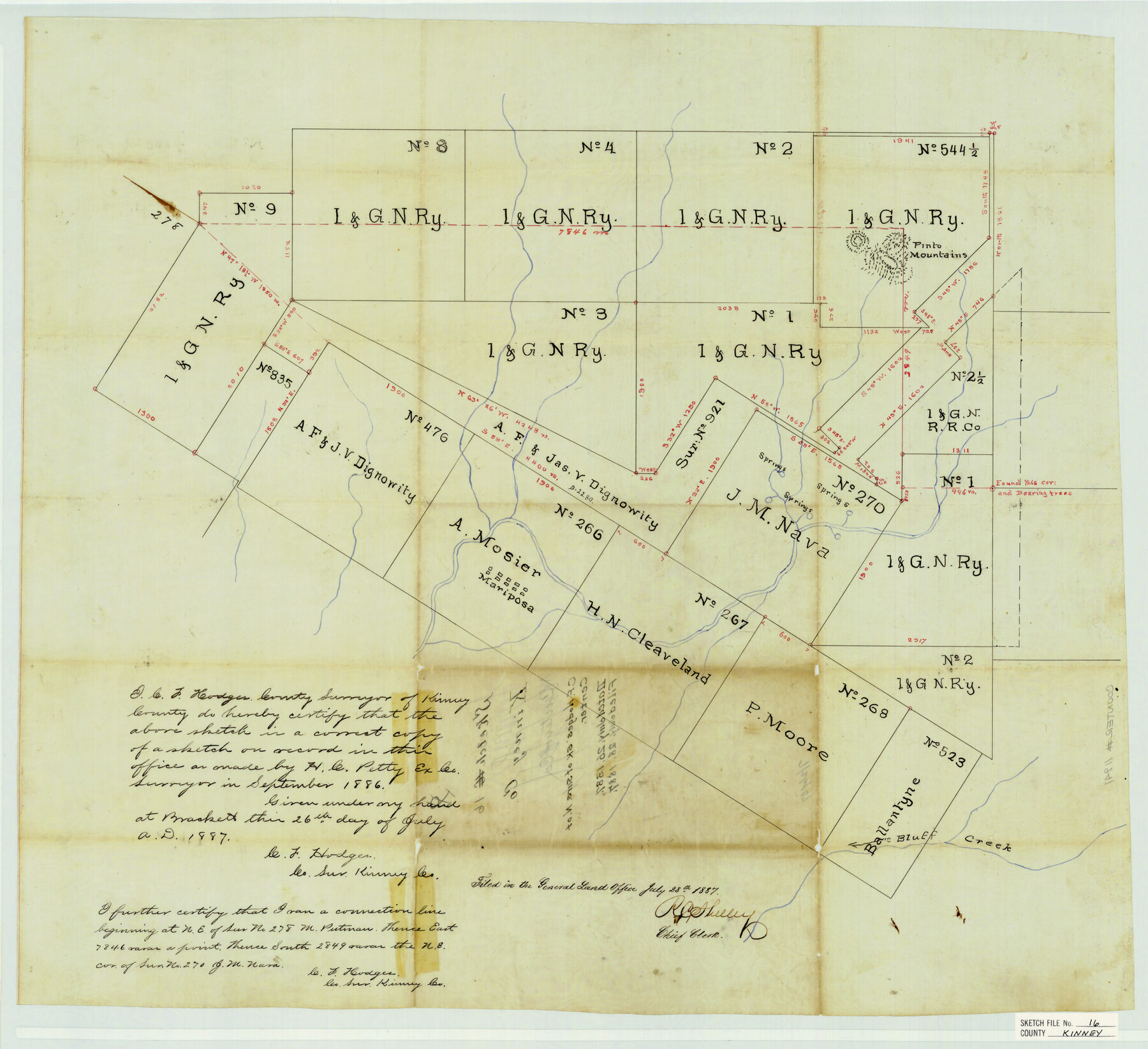
Kinney County Sketch File 16
[Sketch of I. & G. N. Ry. Co. surveys northwest of Brackettville near Pinto Mountains and Mariposa]
- 
                          Map/Doc
11941
 - 
                            Collection
General Map Collection
 - 
                            Object Dates
7/26/1887 (Creation Date)
7/28/1887 (File Date)
9/1886 (Survey Date)
 - 
                            People and Organizations
H.C. Petty (Surveyor/Engineer)
C.F. Hodges (Surveyor/Engineer)
 - 
                            Counties
Kinney
 - 
                            Subjects
Surveying Sketch File
 - 
                            Height x Width
23.2 x 25.4 inches
58.9 x 64.5 cm
 - 
                            Medium
paper, manuscript
 - 
                            Features
Pinto Mountains
Mariposa
Bluff Creek
 
Part of: General Map Collection
            Calhoun County Rolled Sketch 14


                                            Print $20.00                    
                                             -                         Digital $50.00                                    
                Calhoun County Rolled Sketch 14
Size 21.5 x 40.2 inches
                                Map/Doc 5461
            
            Robertson County Working Sketch 8


                                            Print $20.00                    
                                             -                         Digital $50.00                                    
                Robertson County Working Sketch 8
1983
Size 36.7 x 38.7 inches
                                Map/Doc 63581
            
            El Paso County Working Sketch 19


                                            Print $20.00                    
                                             -                         Digital $50.00                                    
                El Paso County Working Sketch 19
1960
Size 20.8 x 20.8 inches
                                Map/Doc 69041
            
            Travis County Rolled Sketch 11


                                            Print $20.00                    
                                             -                         Digital $50.00                                    
                Travis County Rolled Sketch 11
Size 23.3 x 37.9 inches
                                Map/Doc 8014
            
            Map of Extension Line from the Brazos River to the Waters of the Colorado River of the Memphis, El Paso & Pacific R.R. Company Land Reserve


                                            Print $40.00                    
                                             -                         Digital $50.00                                    
                Map of Extension Line from the Brazos River to the Waters of the Colorado River of the Memphis, El Paso & Pacific R.R. Company Land Reserve
1858
Size 16.8 x 82.9 inches
                                Map/Doc 64093
            
            Jefferson County Aerial Photograph Index Sheet 2


                                            Print $20.00                    
                                             -                         Digital $50.00                                    
                Jefferson County Aerial Photograph Index Sheet 2
1953
Size 23.4 x 17.0 inches
                                Map/Doc 83708
            
            Flight Mission No. CRC-3R, Frame 48, Chambers County


                                            Print $20.00                    
                                             -                         Digital $50.00                                    
                Flight Mission No. CRC-3R, Frame 48, Chambers County
1956
Size 18.7 x 22.4 inches
                                Map/Doc 84821
            
            Donley County Sketch File 20 (6a)


                                            Print $20.00                    
                                             -                         Digital $50.00                                    
                Donley County Sketch File 20 (6a)
Size 20.1 x 13.1 inches
                                Map/Doc 11367
            
            Jones County Sketch File 7


                                            Print $20.00                    
                                             -                         Digital $50.00                                    
                Jones County Sketch File 7
Size 12.5 x 27.5 inches
                                Map/Doc 11897
            
            Fractional Township No. 7 South Range No. 4 East of the Indian Meridian, Indian Territory


                                            Print $20.00                    
                                             -                         Digital $50.00                                    
                Fractional Township No. 7 South Range No. 4 East of the Indian Meridian, Indian Territory
1898
Size 19.3 x 24.4 inches
                                Map/Doc 75207
            
            Flight Mission No. DAG-17K, Frame 62, Matagorda County


                                            Print $20.00                    
                                             -                         Digital $50.00                                    
                Flight Mission No. DAG-17K, Frame 62, Matagorda County
1952
Size 16.4 x 16.4 inches
                                Map/Doc 86324
            
            Brewster County Sketch File 19


                                            Print $6.00                    
                                             -                         Digital $50.00                                    
                Brewster County Sketch File 19
1943
Size 13.2 x 8.8 inches
                                Map/Doc 15817
            You may also like
            Gillespie County Boundary File 7a


                                            Print $40.00                    
                                             -                         Digital $50.00                                    
                Gillespie County Boundary File 7a
Size 8.7 x 51.2 inches
                                Map/Doc 53780
            
            Newton County Rolled Sketch 27A


                                            Print $20.00                    
                                             -                         Digital $50.00                                    
                Newton County Rolled Sketch 27A
1961
Size 35.9 x 27.1 inches
                                Map/Doc 6857
            
            A sketch of surveys made on the coast east of Bolivar Point


                                            Print $20.00                    
                                             -                         Digital $50.00                                    
                A sketch of surveys made on the coast east of Bolivar Point
1841
Size 9.1 x 22.0 inches
                                Map/Doc 22
            
            Greer County Sketch File 5


                                            Print $8.00                    
                                             -                         Digital $50.00                                    
                Greer County Sketch File 5
1883
Size 10.0 x 15.6 inches
                                Map/Doc 24521
            
            Flight Mission No. DQO-8K, Frame 48, Galveston County


                                            Print $20.00                    
                                             -                         Digital $50.00                                    
                Flight Mission No. DQO-8K, Frame 48, Galveston County
1952
Size 18.7 x 22.2 inches
                                Map/Doc 85155
            
            Culberson County Rolled Sketch 19


                                            Print $20.00                    
                                             -                         Digital $50.00                                    
                Culberson County Rolled Sketch 19
Size 18.8 x 29.4 inches
                                Map/Doc 5651
            
            [Section of] El Nuevo Mexico y Tierras Adyacentes Mapa Levantado para la demarcacion de los Limites de los Dominios Españoles y de los Estados Unidos


            [Section of] El Nuevo Mexico y Tierras Adyacentes Mapa Levantado para la demarcacion de los Limites de los Dominios Españoles y de los Estados Unidos
1811
Size 17.9 x 26.7 inches
                                Map/Doc 97484
            
            Caldwell County Sketch File 2


                                            Print $40.00                    
                                             -                         Digital $50.00                                    
                Caldwell County Sketch File 2
1877
Size 12.9 x 20.0 inches
                                Map/Doc 11030
            
            Map of Reeves County


                                            Print $20.00                    
                                             -                         Digital $50.00                                    
                Map of Reeves County
1892
Size 47.2 x 35.4 inches
                                Map/Doc 78401
            
            Jackson County Sketch File 9


                                            Print $24.00                    
                                             -                         Digital $50.00                                    
                Jackson County Sketch File 9
1898
Size 11.3 x 8.8 inches
                                Map/Doc 27651
            
            Liberty County Sketch File 65


                                            Print $4.00                    
                                             -                         Digital $50.00                                    
                Liberty County Sketch File 65
1895
Size 11.0 x 8.7 inches
                                Map/Doc 30128
            
            Hardin County Rolled Sketch 15


                                            Print $20.00                    
                                             -                         Digital $50.00                                    
                Hardin County Rolled Sketch 15
1938
Size 30.9 x 23.7 inches
                                Map/Doc 6084