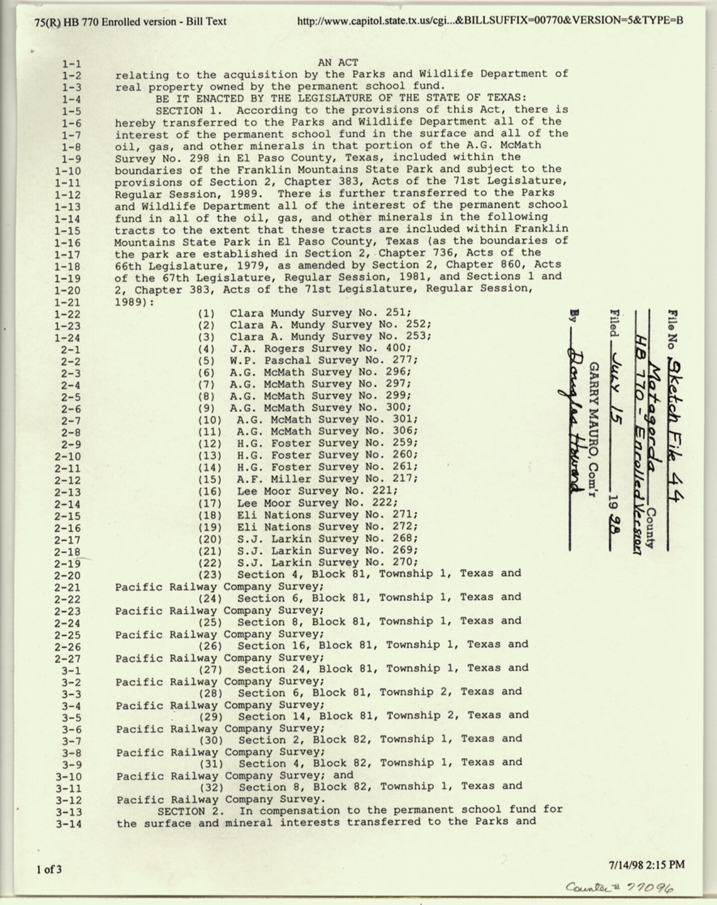
Matagorda County Sketch File 44
Texas General Land Office ownership in the Matagorda Peninsula according to House Bill 770
- 
                          Map/Doc
77096
 - 
                            Collection
General Map Collection
 - 
                            Object Dates
1/1973 (Survey Date)
4/1/1978 (Revision Date)
7/17/1987 (File Date)
7/15/1998 (File Date)
 - 
                            People and Organizations
DuWard Gail Ford (Surveyor/Engineer)
 - 
                            Counties
Matagorda
 - 
                            Subjects
Surveying Sketch File
 - 
                            Height x Width
11.2 x 8.8 inches
28.5 x 22.4 cm
 - 
                            Medium
paper, print
 - 
                            Comments
Includes enrolled (unsigned) copy of House Bill 770, acreage calculations, and sketches.
Shows areas out of the James Duncan League, A-144 and Benjamin Wightman League, A-100.
See Matagorda County Rolled Sketch 39 (10743) for sepia copy of plat. - 
                            Features
Matagorda Peninsula
Matagorda Bay
Gulf of Mexico
 
Related maps
            Matagorda County Rolled Sketch 39


                                            Print $40.00                    
                                             -                         Digital $50.00                                    
                Matagorda County Rolled Sketch 39
1973
Size 24.4 x 114.0 inches
                                Map/Doc 10743
            Part of: General Map Collection
            Flight Mission No. BRA-7M, Frame 33, Jefferson County


                                            Print $20.00                    
                                             -                         Digital $50.00                                    
                Flight Mission No. BRA-7M, Frame 33, Jefferson County
1953
Size 18.6 x 22.4 inches
                                Map/Doc 85484
            
            [Sketch for Mineral Application 11318 - Arenosa Creek, S. G. Drushel]


                                            Print $40.00                    
                                             -                         Digital $50.00                                    
                [Sketch for Mineral Application 11318 - Arenosa Creek, S. G. Drushel]
Size 78.9 x 24.8 inches
                                Map/Doc 65647
            
            Rio Grande - Fernando Sheet


                                            Print $40.00                    
                                             -                         Digital $50.00                                    
                Rio Grande - Fernando Sheet
1925
Size 28.8 x 66.7 inches
                                Map/Doc 65115
            
            Hutchinson County Sketch File 21


                                            Print $22.00                    
                                             -                         Digital $50.00                                    
                Hutchinson County Sketch File 21
Size 8.8 x 7.9 inches
                                Map/Doc 27242
            
            Harris County NRC Article 33.136 Sketch 6


                                            Print $21.00                    
                                             -                         Digital $50.00                                    
                Harris County NRC Article 33.136 Sketch 6
2003
Size 23.1 x 34.8 inches
                                Map/Doc 78664
            
            Erath County Sketch File 13a


                                            Print $6.00                    
                                             -                         Digital $50.00                                    
                Erath County Sketch File 13a
1872
Size 10.3 x 8.2 inches
                                Map/Doc 22287
            
            Coast Chart No. 210 Aransas Pass and Corpus Christi Bay with the coast to latitude 27° 12' Texas


                                            Print $20.00                    
                                             -                         Digital $50.00                                    
                Coast Chart No. 210 Aransas Pass and Corpus Christi Bay with the coast to latitude 27° 12' Texas
1887
Size 26.9 x 18.3 inches
                                Map/Doc 72811
            
            [Map Showing Location and Right of Way of Proposed Groins]


                                            Print $4.00                    
                                             -                         Digital $50.00                                    
                [Map Showing Location and Right of Way of Proposed Groins]
Size 13.4 x 24.4 inches
                                Map/Doc 73623
            
            [Galveston, Harrisburg & San Antonio through El Paso County]


                                            Print $20.00                    
                                             -                         Digital $50.00                                    
                [Galveston, Harrisburg & San Antonio through El Paso County]
1907
Size 13.6 x 33.9 inches
                                Map/Doc 64002
            
            Carta de las provincias de Tejas Nuevo Santander, Nuevo Reino de Leon y Nueva Estremadura


                                            Print $20.00                    
                                             -                         Digital $50.00                                    
                Carta de las provincias de Tejas Nuevo Santander, Nuevo Reino de Leon y Nueva Estremadura
1773
Size 21.5 x 26.6 inches
                                Map/Doc 3031
            
            Map of the Fort Worth & Denver City Railway


                                            Print $40.00                    
                                             -                         Digital $50.00                                    
                Map of the Fort Worth & Denver City Railway
1887
Size 21.7 x 72.8 inches
                                Map/Doc 64479
            
            Duval County Working Sketch 49


                                            Print $40.00                    
                                             -                         Digital $50.00                                    
                Duval County Working Sketch 49
1981
Size 37.0 x 81.3 inches
                                Map/Doc 68773
            You may also like
            Reeves County Working Sketch 46


                                            Print $40.00                    
                                             -                         Digital $50.00                                    
                Reeves County Working Sketch 46
1974
Size 52.4 x 37.2 inches
                                Map/Doc 63489
            
            Flight Mission No. CUG-1P, Frame 166, Kleberg County


                                            Print $20.00                    
                                             -                         Digital $50.00                                    
                Flight Mission No. CUG-1P, Frame 166, Kleberg County
1956
Size 18.8 x 22.4 inches
                                Map/Doc 86173
            
            East Part of Blk. No. 1, H. &G. N. R. R. Co. Survey


                                            Print $40.00                    
                                             -                         Digital $50.00                                    
                East Part of Blk. No. 1, H. &G. N. R. R. Co. Survey
Size 22.7 x 60.6 inches
                                Map/Doc 89626
            
            Cass County Rolled Sketch WDC


                                            Print $20.00                    
                                             -                         Digital $50.00                                    
                Cass County Rolled Sketch WDC
Size 20.8 x 32.9 inches
                                Map/Doc 5416
            
            Dallas County Working Sketch 17


                                            Print $40.00                    
                                             -                         Digital $50.00                                    
                Dallas County Working Sketch 17
Size 23.3 x 50.5 inches
                                Map/Doc 68583
            
            Hays County Sketch File C


                                            Print $40.00                    
                                             -                         Digital $50.00                                    
                Hays County Sketch File C
Size 17.9 x 14.6 inches
                                Map/Doc 26197
            
            Rand, McNally Official 1922 Auto Trails Map, District Number 18


                                            Print $20.00                    
                                             -                         Digital $50.00                                    
                Rand, McNally Official 1922 Auto Trails Map, District Number 18
1922
Size 27.1 x 34.7 inches
                                Map/Doc 95887
            
            Matagorda County Sketch File 7


                                            Print $20.00                    
                                             -                         Digital $50.00                                    
                Matagorda County Sketch File 7
1890
Size 37.3 x 24.6 inches
                                Map/Doc 12038
            
            Flight Mission No. CRC-1R, Frame 34, Chambers County


                                            Print $20.00                    
                                             -                         Digital $50.00                                    
                Flight Mission No. CRC-1R, Frame 34, Chambers County
1956
Size 18.8 x 22.4 inches
                                Map/Doc 84702
            
            Lampasas County Working Sketch 5


                                            Print $20.00                    
                                             -                         Digital $50.00                                    
                Lampasas County Working Sketch 5
1947
Size 25.6 x 31.8 inches
                                Map/Doc 70282
            
            Marion County Working Sketch Graphic Index, Sheet 1 (Sketches 1 to 26)


                                            Print $20.00                    
                                             -                         Digital $50.00                                    
                Marion County Working Sketch Graphic Index, Sheet 1 (Sketches 1 to 26)
1943
Size 26.8 x 45.1 inches
                                Map/Doc 76629
            
            Terry County Boundary File 1


                                            Print $4.00                    
                                             -                         Digital $50.00                                    
                Terry County Boundary File 1
Size 11.6 x 9.0 inches
                                Map/Doc 59202