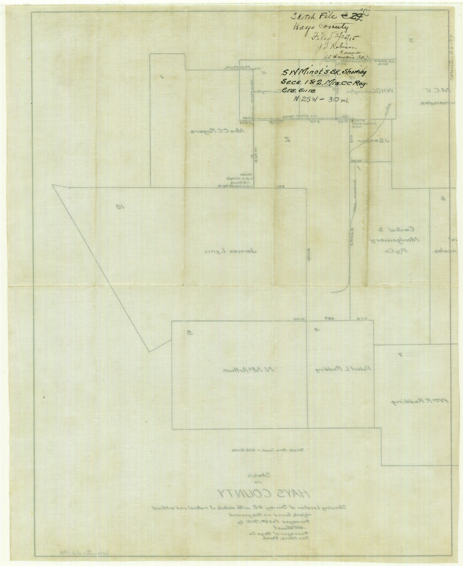
Hays County Sketch File C
[Sketch showing Mrs. C. C. Rogers surveys 1 and 2]
-
Map/Doc
26197
-
Collection
General Map Collection
-
Object Dates
2/25/1915 (File Date)
-
People and Organizations
S.W. Minot (Surveyor/Engineer)
-
Counties
Hays
-
Subjects
Surveying Sketch File
-
Height x Width
17.9 x 14.6 inches
45.5 x 37.1 cm
-
Medium
paper, manuscript
-
Scale
1:500
-
Features
Deadman's Creek
West Prong of Deadman's Creek
Part of: General Map Collection
Culberson County Sketch File 31

Print $4.00
- Digital $50.00
Culberson County Sketch File 31
1951
Size 11.3 x 8.9 inches
Map/Doc 20283
Travis County Working Sketch 65

Print $20.00
- Digital $50.00
Travis County Working Sketch 65
2003
Size 28.1 x 38.3 inches
Map/Doc 78494
Taylor County Working Sketch 8

Print $40.00
- Digital $50.00
Taylor County Working Sketch 8
1953
Size 73.2 x 43.1 inches
Map/Doc 69618
Coke County Sketch File 30

Print $40.00
- Digital $50.00
Coke County Sketch File 30
Size 12.2 x 17.6 inches
Map/Doc 18641
Jefferson County Rolled Sketch 25

Print $20.00
- Digital $50.00
Jefferson County Rolled Sketch 25
1939
Size 43.4 x 36.0 inches
Map/Doc 9290
Culberson County Rolled Sketch 15

Print $20.00
- Digital $50.00
Culberson County Rolled Sketch 15
1904
Size 30.5 x 40.2 inches
Map/Doc 8744
A New Map of the Whole Continent of America. Divided into North and South and West Indies, wherein are exactly decribed the United States of North America as well as the Several European Possessions according to the Preliminaries of Peace…

Print $40.00
- Digital $50.00
A New Map of the Whole Continent of America. Divided into North and South and West Indies, wherein are exactly decribed the United States of North America as well as the Several European Possessions according to the Preliminaries of Peace…
Size 22.0 x 48.3 inches
Map/Doc 95135
Stephens County Working Sketch 13

Print $20.00
- Digital $50.00
Stephens County Working Sketch 13
1952
Size 23.9 x 33.3 inches
Map/Doc 63956
Johnson's New Military Map of the United States Showing the Forts, Military Posts & c. with Enlarged Plans of Southern Harbors

Print $20.00
- Digital $50.00
Johnson's New Military Map of the United States Showing the Forts, Military Posts & c. with Enlarged Plans of Southern Harbors
1863
Size 17.7 x 23.3 inches
Map/Doc 93289
Somervell County Working Sketch 6

Print $20.00
- Digital $50.00
Somervell County Working Sketch 6
1992
Size 23.2 x 21.5 inches
Map/Doc 63910
Van Zandt County Boundary File 2a

Print $20.00
- Digital $50.00
Van Zandt County Boundary File 2a
Size 20.3 x 20.1 inches
Map/Doc 59649
Flight Mission No. CRC-2R, Frame 136, Chambers County

Print $20.00
- Digital $50.00
Flight Mission No. CRC-2R, Frame 136, Chambers County
1956
Size 18.7 x 22.4 inches
Map/Doc 84752
You may also like
Maps of Block 97, Borden & Scurry Counties

Print $40.00
- Digital $50.00
Maps of Block 97, Borden & Scurry Counties
Size 58.2 x 42.2 inches
Map/Doc 65691
The Republic County of Fort Bend. January 28, 1841

Print $20.00
The Republic County of Fort Bend. January 28, 1841
2020
Size 14.7 x 21.6 inches
Map/Doc 96140
Schleicher County Sketch File 15

Print $22.00
- Digital $50.00
Schleicher County Sketch File 15
1928
Size 8.1 x 12.9 inches
Map/Doc 36504
Carte Nouvelle de la Mer du Sud

Print $20.00
- Digital $50.00
Carte Nouvelle de la Mer du Sud
1730
Size 25.8 x 39.6 inches
Map/Doc 93824
Edwards County Working Sketch 113

Print $20.00
- Digital $50.00
Edwards County Working Sketch 113
1972
Size 39.1 x 36.0 inches
Map/Doc 68989

Van Zandt County Sketch File 20a

Print $4.00
- Digital $50.00
Van Zandt County Sketch File 20a
1858
Size 12.9 x 8.0 inches
Map/Doc 39428
[Southwest corner of Runnels County School Land League 3]
![91586, [Southwest corner of Runnels County School Land League 3], Twichell Survey Records](https://historictexasmaps.com/wmedia_w700/maps/91586-1.tif.jpg)
Print $2.00
- Digital $50.00
[Southwest corner of Runnels County School Land League 3]
1927
Size 14.2 x 8.7 inches
Map/Doc 91586
Texas, an Agricultural Empire

Texas, an Agricultural Empire
1915
Size 10.8 x 8.0 inches
Map/Doc 96593
Archer County Working Sketch Graphic Index

Print $20.00
- Digital $50.00
Archer County Working Sketch Graphic Index
1926
Size 46.7 x 39.4 inches
Map/Doc 76456
Pecos County Rolled Sketch 191

Print $20.00
- Digital $50.00
Pecos County Rolled Sketch 191
Size 18.2 x 27.4 inches
Map/Doc 95397
Current Miscellaneous File 92

Print $22.00
- Digital $50.00
Current Miscellaneous File 92
1990
Size 11.2 x 8.8 inches
Map/Doc 74265