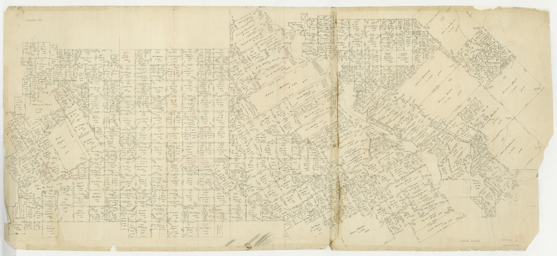
Dallas County Working Sketch 17
-
Map/Doc
68583
-
Collection
General Map Collection
-
Counties
Dallas
-
Subjects
Surveying Working Sketch
-
Height x Width
23.3 x 50.5 inches
59.2 x 128.3 cm
Part of: General Map Collection
Houston County Working Sketch 4

Print $20.00
- Digital $50.00
Houston County Working Sketch 4
1911
Size 15.5 x 21.8 inches
Map/Doc 66234
Culberson County Working Sketch 39

Print $40.00
- Digital $50.00
Culberson County Working Sketch 39
1966
Size 37.9 x 82.7 inches
Map/Doc 68492
Flight Mission No. DQN-1K, Frame 68, Calhoun County

Print $20.00
- Digital $50.00
Flight Mission No. DQN-1K, Frame 68, Calhoun County
1953
Size 18.6 x 22.2 inches
Map/Doc 84155
Irion County Rolled Sketch 23

Print $40.00
- Digital $50.00
Irion County Rolled Sketch 23
Size 42.9 x 49.1 inches
Map/Doc 10302
Galveston Harbor and Channel, Texas Rehabilitation of South Jetty, Comparison of Shorelines and Offshore Contours 1890 to 1960

Print $20.00
- Digital $50.00
Galveston Harbor and Channel, Texas Rehabilitation of South Jetty, Comparison of Shorelines and Offshore Contours 1890 to 1960
1961
Size 31.6 x 41.8 inches
Map/Doc 61827
Gaines County Working Sketch 32

Print $20.00
- Digital $50.00
Gaines County Working Sketch 32
1990
Size 38.3 x 26.3 inches
Map/Doc 69332
Comal County Sketch File 20

Print $6.00
- Digital $50.00
Comal County Sketch File 20
1857
Size 12.4 x 8.1 inches
Map/Doc 19039
Flight Mission No. CRE-1R, Frame 135, Jackson County

Print $20.00
- Digital $50.00
Flight Mission No. CRE-1R, Frame 135, Jackson County
1956
Size 16.2 x 15.8 inches
Map/Doc 85343

Morris County Rolled Sketch 2A

Print $20.00
- Digital $50.00
Morris County Rolled Sketch 2A
Size 34.7 x 24.7 inches
Map/Doc 10229
Flight Mission No. BRA-6M, Frame 98, Jefferson County

Print $20.00
- Digital $50.00
Flight Mission No. BRA-6M, Frame 98, Jefferson County
1953
Size 18.5 x 22.2 inches
Map/Doc 85441
You may also like
McMullen County Working Sketch 22

Print $40.00
- Digital $50.00
McMullen County Working Sketch 22
1947
Size 39.1 x 53.3 inches
Map/Doc 70723
Cherokee County Boundary File 2

Print $11.00
- Digital $50.00
Cherokee County Boundary File 2
Size 16.1 x 9.9 inches
Map/Doc 51280
Newton County Sketch File 37

Print $6.00
- Digital $50.00
Newton County Sketch File 37
Size 16.2 x 10.7 inches
Map/Doc 32415
[Surveys along the Lavaca River]
![25, [Surveys along the Lavaca River], General Map Collection](https://historictexasmaps.com/wmedia_w700/maps/25.tif.jpg)
Print $2.00
- Digital $50.00
[Surveys along the Lavaca River]
1833
Size 12.9 x 8.9 inches
Map/Doc 25
Bandera County Sketch File 22

Print $4.00
- Digital $50.00
Bandera County Sketch File 22
Size 12.6 x 7.9 inches
Map/Doc 14012
Victoria County Sketch File 3

Print $7.00
- Digital $50.00
Victoria County Sketch File 3
1876
Size 10.1 x 8.2 inches
Map/Doc 39514
Armstrong County Sketch File 1

Print $4.00
- Digital $50.00
Armstrong County Sketch File 1
Size 8.1 x 10.6 inches
Map/Doc 13685
Hardin County Sketch File 5

Print $5.00
- Digital $50.00
Hardin County Sketch File 5
1856
Size 9.0 x 6.6 inches
Map/Doc 25092
Rio Grande Rectification Project, El Paso and Juarez Valley

Print $20.00
- Digital $50.00
Rio Grande Rectification Project, El Paso and Juarez Valley
1935
Size 11.0 x 29.6 inches
Map/Doc 60871
Knox County Boundary File 5a

Print $22.00
- Digital $50.00
Knox County Boundary File 5a
Size 15.6 x 38.5 inches
Map/Doc 65047
Eastland County Working Sketch 36

Print $20.00
- Digital $50.00
Eastland County Working Sketch 36
1963
Size 24.0 x 40.0 inches
Map/Doc 68817
Entrance to Sabine Pass, Texas from survey of May and June 1892 under the direction of Major James B. Quinn, Corps of Engineers, USA

Print $20.00
- Digital $50.00
Entrance to Sabine Pass, Texas from survey of May and June 1892 under the direction of Major James B. Quinn, Corps of Engineers, USA
1892
Size 18.8 x 32.9 inches
Map/Doc 94154