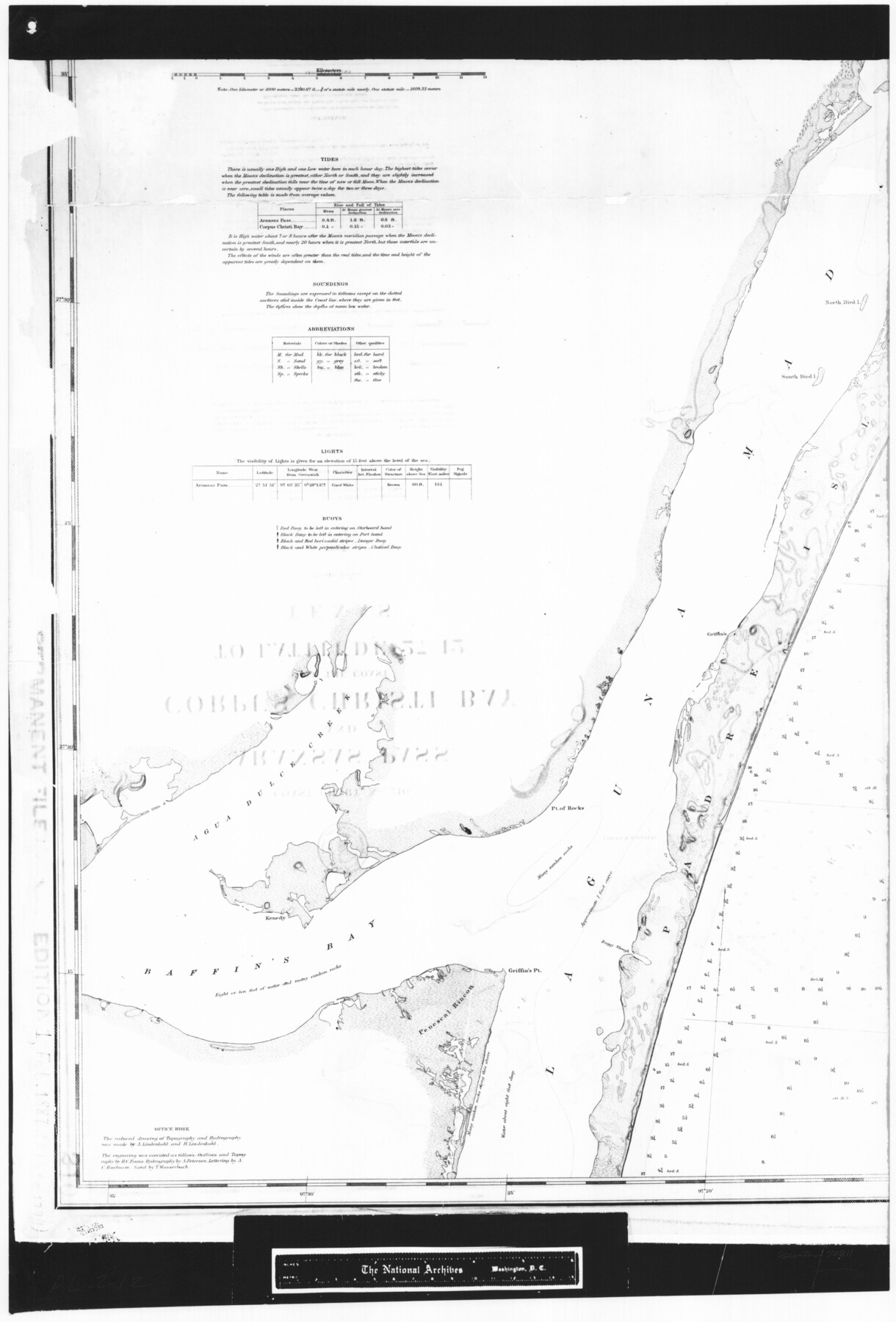
Coast Chart No. 210 Aransas Pass and Corpus Christi Bay with the coast to latitude 27° 12' Texas
RL-2-12
-
Map/Doc
72811
-
Collection
General Map Collection
-
Object Dates
1887 (Creation Date)
-
People and Organizations
[U. S. Coast and Geodetic Survey] (Publisher)
-
Counties
Nueces
-
Subjects
Nautical Charts
-
Height x Width
26.9 x 18.3 inches
68.3 x 46.5 cm
-
Comments
B/W photostat copy from National Archives in multiple pieces.
Part of: General Map Collection
Presidio County Sketch File 5

Print $4.00
- Digital $50.00
Presidio County Sketch File 5
1872
Size 12.9 x 8.2 inches
Map/Doc 34433
Montgomery County Working Sketch 71

Print $20.00
- Digital $50.00
Montgomery County Working Sketch 71
1979
Size 37.2 x 29.8 inches
Map/Doc 71178
Polk County Sketch File 35

Print $8.00
- Digital $50.00
Polk County Sketch File 35
1891
Size 14.2 x 8.7 inches
Map/Doc 34232
Rusk County Working Sketch 19

Print $20.00
- Digital $50.00
Rusk County Working Sketch 19
1955
Size 19.0 x 18.2 inches
Map/Doc 63654
Flight Mission No. DIX-7P, Frame 18, Aransas County

Print $20.00
- Digital $50.00
Flight Mission No. DIX-7P, Frame 18, Aransas County
1956
Size 19.0 x 22.6 inches
Map/Doc 83870
Wichita County Working Sketch 13

Print $20.00
- Digital $50.00
Wichita County Working Sketch 13
1921
Size 16.5 x 32.8 inches
Map/Doc 72523
[Map of Line Dividing Fannin and Nacogdoches Districts]
![1707, [Map of Line Dividing Fannin and Nacogdoches Districts], General Map Collection](https://historictexasmaps.com/wmedia_w700/maps/1707-1.tif.jpg)
Print $20.00
- Digital $50.00
[Map of Line Dividing Fannin and Nacogdoches Districts]
1850
Size 34.2 x 39.0 inches
Map/Doc 1707
Bee County Working Sketch 16

Print $20.00
- Digital $50.00
Bee County Working Sketch 16
1974
Size 18.0 x 19.6 inches
Map/Doc 67266
San Jacinto County Sketch File 20A

Print $6.00
San Jacinto County Sketch File 20A
1939
Size 13.9 x 8.9 inches
Map/Doc 35731
Briscoe County

Print $20.00
- Digital $50.00
Briscoe County
1881
Size 26.8 x 21.5 inches
Map/Doc 3333
Duval County Rolled Sketch E

Print $20.00
- Digital $50.00
Duval County Rolled Sketch E
1935
Size 36.4 x 37.7 inches
Map/Doc 8808
Live Oak County Working Sketch 35

Print $20.00
- Digital $50.00
Live Oak County Working Sketch 35
2003
Size 36.4 x 34.7 inches
Map/Doc 82446
You may also like
Newton County Sketch File 48

Print $4.00
- Digital $50.00
Newton County Sketch File 48
Size 12.4 x 7.9 inches
Map/Doc 32460
Flight Mission No. BQR-13K, Frame 121, Brazoria County

Print $20.00
- Digital $50.00
Flight Mission No. BQR-13K, Frame 121, Brazoria County
1952
Size 18.6 x 22.3 inches
Map/Doc 84082
Reeves County Rolled Sketch 16

Print $20.00
- Digital $50.00
Reeves County Rolled Sketch 16
1963
Size 22.3 x 27.3 inches
Map/Doc 7485
Lampasas River, City of Lampasas, Lampasas Sheet/Sulphur & Burleson Creeks

Print $20.00
- Digital $50.00
Lampasas River, City of Lampasas, Lampasas Sheet/Sulphur & Burleson Creeks
1937
Size 33.4 x 19.3 inches
Map/Doc 16956
Marion County

Print $20.00
- Digital $50.00
Marion County
1943
Size 29.2 x 46.3 inches
Map/Doc 73229
Right of Way Map, Belton Branch of the M.K.&T. RR.

Print $20.00
- Digital $50.00
Right of Way Map, Belton Branch of the M.K.&T. RR.
1896
Size 14.5 x 42.1 inches
Map/Doc 64219
[County Line between Dickens and Kent Counties]
![90938, [County Line between Dickens and Kent Counties], Twichell Survey Records](https://historictexasmaps.com/wmedia_w700/maps/90938-1.tif.jpg)
Print $20.00
- Digital $50.00
[County Line between Dickens and Kent Counties]
1891
Size 42.4 x 7.4 inches
Map/Doc 90938
Mason County Boundary File 63

Print $10.00
- Digital $50.00
Mason County Boundary File 63
Size 9.4 x 5.9 inches
Map/Doc 56879
Bee County Sketch File 10

Print $4.00
- Digital $50.00
Bee County Sketch File 10
Size 12.8 x 7.9 inches
Map/Doc 14291
Maps of Gulf Intracoastal Waterway, Texas - Sabine River to the Rio Grande and connecting waterways including ship channels

Print $20.00
- Digital $50.00
Maps of Gulf Intracoastal Waterway, Texas - Sabine River to the Rio Grande and connecting waterways including ship channels
1966
Size 14.6 x 22.2 inches
Map/Doc 61975
Irion County Working Sketch 9

Print $20.00
- Digital $50.00
Irion County Working Sketch 9
1941
Size 13.6 x 17.2 inches
Map/Doc 66418
