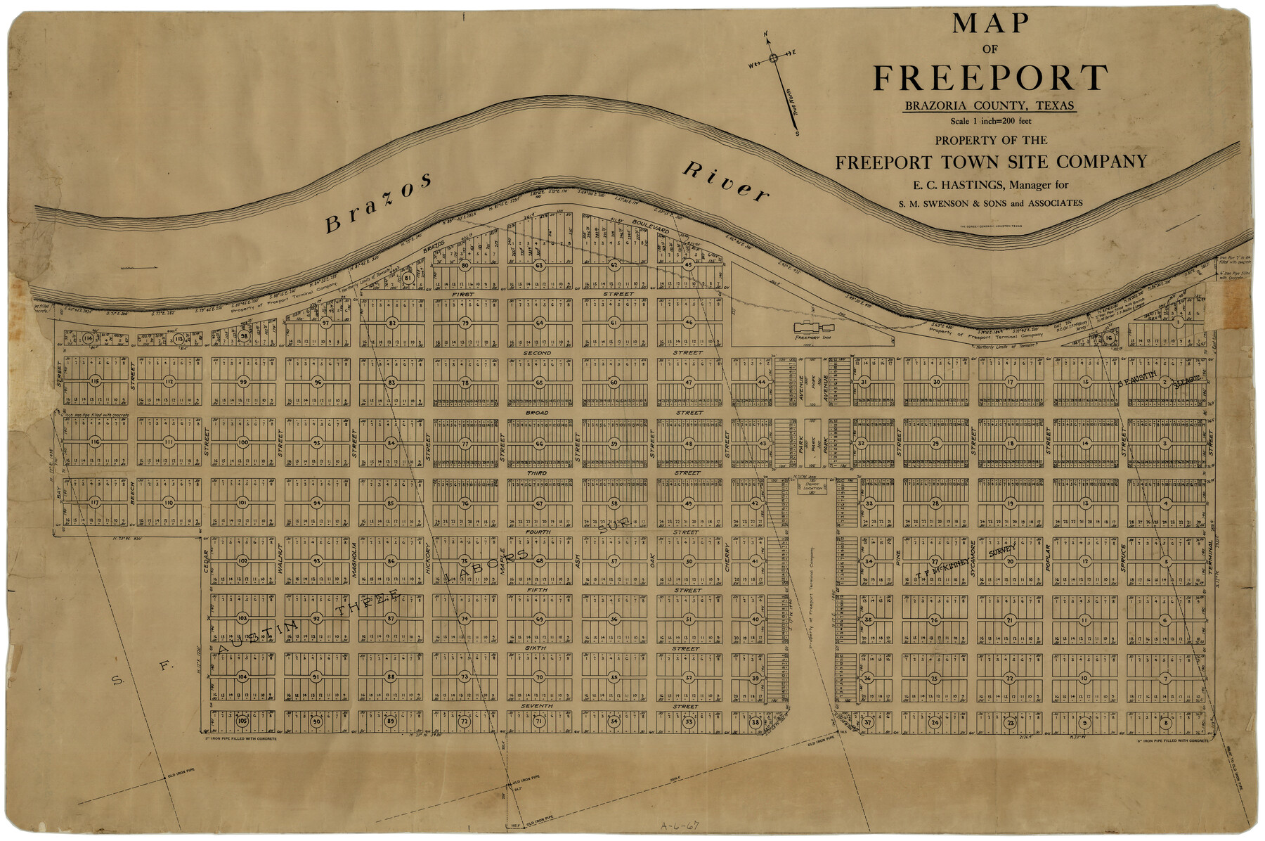
Map of Freeport, Brazoria County, Texas
Brazoria County Rolled Sketch CF, A-6-67
-
Map/Doc
7689
-
Collection
General Map Collection
-
People and Organizations
The Dorsey Company (Printer)
-
Counties
Brazoria
-
Subjects
City
-
Height x Width
27.0 x 39.1 inches
68.6 x 99.3 cm
-
Medium
paper, etching/engraving/lithograph
-
Scale
1" = 200 ft.
-
Features
Brazos River
Part of: General Map Collection
Aransas County Aerial Photograph Index Sheet 2

Print $20.00
- Digital $50.00
Aransas County Aerial Photograph Index Sheet 2
1957
Size 23.0 x 17.9 inches
Map/Doc 83660
Roberts County Working Sketch 10

Print $20.00
- Digital $50.00
Roberts County Working Sketch 10
1965
Size 23.0 x 29.0 inches
Map/Doc 63536
Pecos County Rolled Sketch 54

Print $11.00
- Digital $50.00
Pecos County Rolled Sketch 54
1916
Size 9.7 x 15.0 inches
Map/Doc 48099
Flight Mission No. CRC-4R, Frame 83, Chambers County

Print $20.00
- Digital $50.00
Flight Mission No. CRC-4R, Frame 83, Chambers County
1956
Size 18.8 x 22.5 inches
Map/Doc 84888
Aransas County Sketch File 25

Print $20.00
- Digital $50.00
Aransas County Sketch File 25
Size 17.0 x 17.5 inches
Map/Doc 13218
Carson County Boundary File 4

Print $4.00
- Digital $50.00
Carson County Boundary File 4
Size 9.6 x 6.2 inches
Map/Doc 51132
Moore County Rolled Sketch 11

Print $20.00
- Digital $50.00
Moore County Rolled Sketch 11
Size 34.1 x 43.0 inches
Map/Doc 9549
Map of Bexar County

Print $40.00
- Digital $50.00
Map of Bexar County
1845
Size 48.8 x 43.0 inches
Map/Doc 87237
Wharton County Sketch File 10

Print $4.00
- Digital $50.00
Wharton County Sketch File 10
1882
Size 10.9 x 8.5 inches
Map/Doc 39931
Goliad County Boundary File 33

Print $12.00
- Digital $50.00
Goliad County Boundary File 33
Size 9.4 x 4.2 inches
Map/Doc 53797
[St. L. S-W. Ry. Of Texas Map of Lufkin Branch in Cherokee County Texas]
![64022, [St. L. S-W. Ry. Of Texas Map of Lufkin Branch in Cherokee County Texas], General Map Collection](https://historictexasmaps.com/wmedia_w700/maps/64022.tif.jpg)
Print $40.00
- Digital $50.00
[St. L. S-W. Ry. Of Texas Map of Lufkin Branch in Cherokee County Texas]
1912
Size 23.1 x 122.7 inches
Map/Doc 64022
Map of Rains County

Print $20.00
- Digital $50.00
Map of Rains County
1873
Size 12.0 x 12.4 inches
Map/Doc 4619
You may also like
[Plat of West Part of Section 144, Block B5]
![90602, [Plat of West Part of Section 144, Block B5], Twichell Survey Records](https://historictexasmaps.com/wmedia_w700/maps/90602-1.tif.jpg)
Print $2.00
- Digital $50.00
[Plat of West Part of Section 144, Block B5]
1931
Size 8.7 x 14.3 inches
Map/Doc 90602
Williamson County Boundary File 1a

Print $4.00
- Digital $50.00
Williamson County Boundary File 1a
Size 11.0 x 8.4 inches
Map/Doc 59990
Flight Mission No. CGI-3N, Frame 129, Cameron County

Print $20.00
- Digital $50.00
Flight Mission No. CGI-3N, Frame 129, Cameron County
1954
Size 18.5 x 22.2 inches
Map/Doc 84602
Galveston Bay, Texas

Print $20.00
- Digital $50.00
Galveston Bay, Texas
1905
Size 24.8 x 18.5 inches
Map/Doc 65390
South Sulphur River, Klondike Sheet

Print $20.00
- Digital $50.00
South Sulphur River, Klondike Sheet
1925
Size 18.2 x 19.9 inches
Map/Doc 78332
Brazoria County Rolled Sketch 50

Print $20.00
- Digital $50.00
Brazoria County Rolled Sketch 50
1914
Size 18.4 x 26.4 inches
Map/Doc 5187
San Patricio County Sketch File 9

Print $2.00
- Digital $50.00
San Patricio County Sketch File 9
1846
Size 8.3 x 8.7 inches
Map/Doc 36039
[Block Y and vicinity]
![91177, [Block Y and vicinity], Twichell Survey Records](https://historictexasmaps.com/wmedia_w700/maps/91177-1.tif.jpg)
Print $20.00
- Digital $50.00
[Block Y and vicinity]
Size 17.7 x 14.6 inches
Map/Doc 91177
Texas Land Commissioner Jerry Patterson's Great Military Map of Texas showing Significant Conflicts and Events between 1685 and 1916

Print $20.00
- Digital $50.00
Texas Land Commissioner Jerry Patterson's Great Military Map of Texas showing Significant Conflicts and Events between 1685 and 1916
2006
Size 36.7 x 24.8 inches
Map/Doc 83432
Reeves County Rolled Sketch 22

Print $20.00
- Digital $50.00
Reeves County Rolled Sketch 22
1960
Size 40.8 x 20.9 inches
Map/Doc 7490
Coast Chart No. 211 - Padre I. and Laguna Madre Lat. 27° 12' to Lat. 26° 33' Texas

Print $20.00
- Digital $50.00
Coast Chart No. 211 - Padre I. and Laguna Madre Lat. 27° 12' to Lat. 26° 33' Texas
1890
Size 27.5 x 18.3 inches
Map/Doc 72823
Brown County Working Sketch 12

Print $20.00
- Digital $50.00
Brown County Working Sketch 12
1984
Size 27.0 x 25.2 inches
Map/Doc 67777