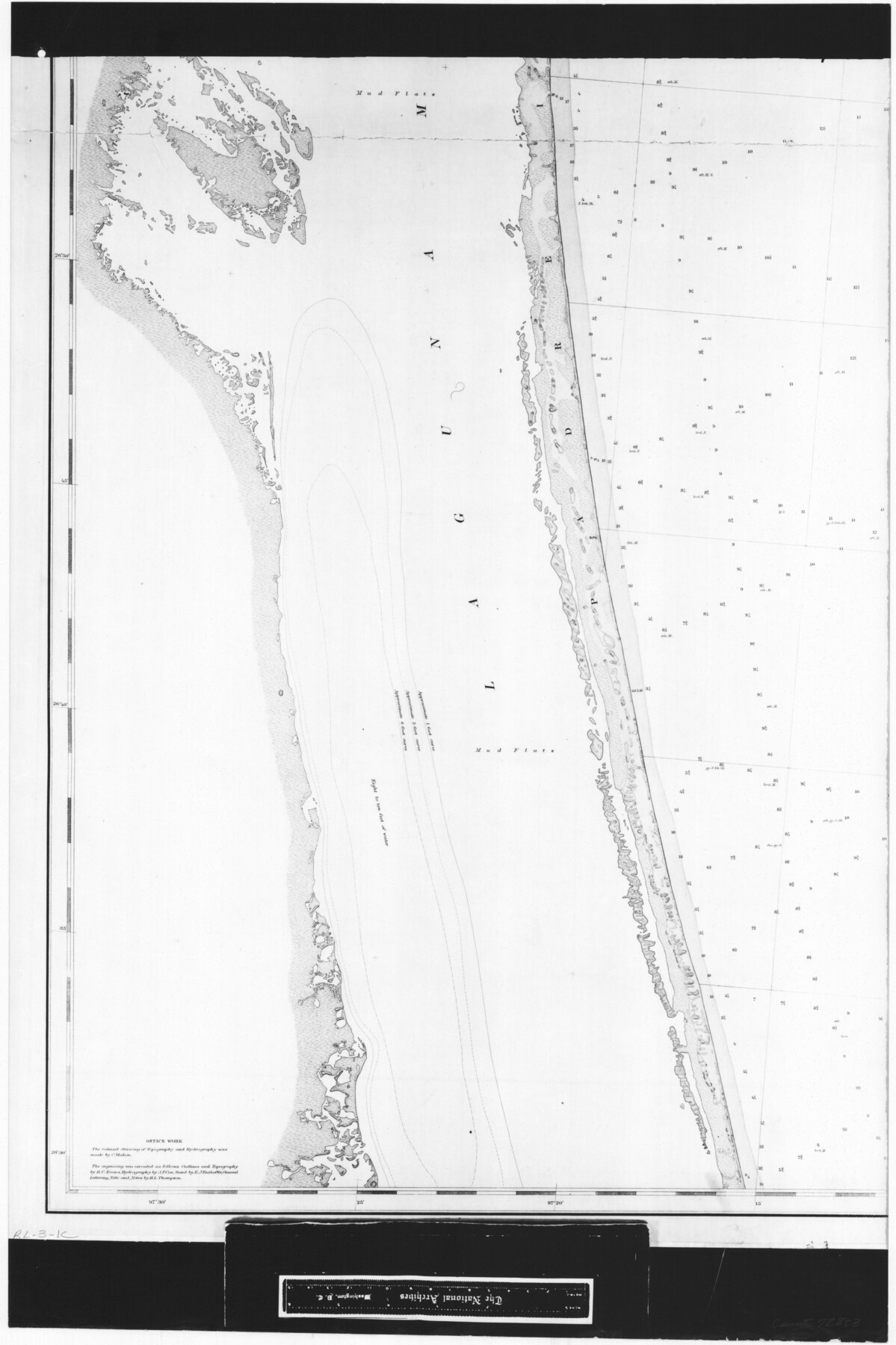
Coast Chart No. 211 - Padre I. and Laguna Madre Lat. 27° 12' to Lat. 26° 33' Texas
RL-3-1c
-
Map/Doc
72823
-
Collection
General Map Collection
-
Object Dates
1890 (Creation Date)
-
People and Organizations
U. S. Coastal and Geodetic Survey (Publisher)
C. Mahon (Draftsman)
-
Counties
Nueces
-
Subjects
Nautical Charts
-
Height x Width
27.5 x 18.3 inches
69.9 x 46.5 cm
-
Comments
B/W photostat copy from National Archives in multiple pieces.
Part of: General Map Collection
Gillespie County Working Sketch 2

Print $20.00
- Digital $50.00
Gillespie County Working Sketch 2
1958
Size 35.9 x 26.0 inches
Map/Doc 63165
Stonewall County Rolled Sketch 20

Print $40.00
- Digital $50.00
Stonewall County Rolled Sketch 20
Size 36.7 x 55.7 inches
Map/Doc 49129
Hardin County Working Sketch 20

Print $20.00
- Digital $50.00
Hardin County Working Sketch 20
1947
Size 38.1 x 32.6 inches
Map/Doc 63418
Runnels County Sketch File 3

Print $4.00
Runnels County Sketch File 3
1871
Size 13.0 x 8.1 inches
Map/Doc 35432
Pecos County Boundary File 69a

Print $40.00
- Digital $50.00
Pecos County Boundary File 69a
Size 8.4 x 9.7 inches
Map/Doc 57901
Garza County Sketch File B

Print $20.00
- Digital $50.00
Garza County Sketch File B
1898
Size 19.3 x 29.4 inches
Map/Doc 11549
Blanco County Sketch File 37

Print $4.00
- Digital $50.00
Blanco County Sketch File 37
Size 8.7 x 14.1 inches
Map/Doc 14646
Tarrant County Sketch File 16

Print $4.00
- Digital $50.00
Tarrant County Sketch File 16
1861
Size 8.2 x 6.4 inches
Map/Doc 37710
Hudspeth County Rolled Sketch 75

Print $40.00
- Digital $50.00
Hudspeth County Rolled Sketch 75
1992
Size 35.6 x 48.9 inches
Map/Doc 9238
Supreme Court of the United States, October Term, 1923, No. 15, Original - The State of Oklahoma, Complainant vs. The State of Texas, Defendant, The United States, Intervener; Report of the Boundary Commissioners

Print $98.00
- Digital $50.00
Supreme Court of the United States, October Term, 1923, No. 15, Original - The State of Oklahoma, Complainant vs. The State of Texas, Defendant, The United States, Intervener; Report of the Boundary Commissioners
1924
Size 6.1 x 9.2 inches
Map/Doc 3058
Tarrant County

Print $20.00
- Digital $50.00
Tarrant County
1873
Size 19.6 x 18.0 inches
Map/Doc 4630
Medina County Working Sketch 19

Print $20.00
- Digital $50.00
Medina County Working Sketch 19
1980
Size 19.4 x 29.1 inches
Map/Doc 70934
You may also like
Ochiltree County Working Sketch 3

Print $40.00
- Digital $50.00
Ochiltree County Working Sketch 3
1961
Size 111.8 x 37.5 inches
Map/Doc 71316
Duval County Boundary File 3a

Print $8.00
- Digital $50.00
Duval County Boundary File 3a
Size 12.7 x 8.0 inches
Map/Doc 52726
Bowie County Working Sketch 19

Print $20.00
- Digital $50.00
Bowie County Working Sketch 19
1962
Size 23.3 x 17.9 inches
Map/Doc 67423
Rusk County Working Sketch 37a

Print $40.00
- Digital $50.00
Rusk County Working Sketch 37a
2007
Size 54.5 x 34.2 inches
Map/Doc 87496

Jefferson County NRC Article 33.136 Sketch 7

Print $24.00
- Digital $50.00
Jefferson County NRC Article 33.136 Sketch 7
2009
Size 30.8 x 43.0 inches
Map/Doc 94711
Map of Trinity County Texas

Print $20.00
- Digital $50.00
Map of Trinity County Texas
1859
Size 21.5 x 30.6 inches
Map/Doc 4095
Van Zandt County Sketch File 16

Print $4.00
- Digital $50.00
Van Zandt County Sketch File 16
1858
Size 6.8 x 8.0 inches
Map/Doc 39410
Kleberg County Aerial Photograph Index Sheet 2

Print $20.00
- Digital $50.00
Kleberg County Aerial Photograph Index Sheet 2
1956
Size 19.4 x 23.4 inches
Map/Doc 83719
Flight Mission No. BRA-7M, Frame 128, Jefferson County

Print $20.00
- Digital $50.00
Flight Mission No. BRA-7M, Frame 128, Jefferson County
1953
Size 18.8 x 22.5 inches
Map/Doc 85522
Calhoun County Rolled Sketch 29B

Print $20.00
- Digital $50.00
Calhoun County Rolled Sketch 29B
Size 43.4 x 45.0 inches
Map/Doc 8558
Navarro County Sketch File 13

Print $22.00
- Digital $50.00
Navarro County Sketch File 13
Size 12.0 x 8.6 inches
Map/Doc 32324