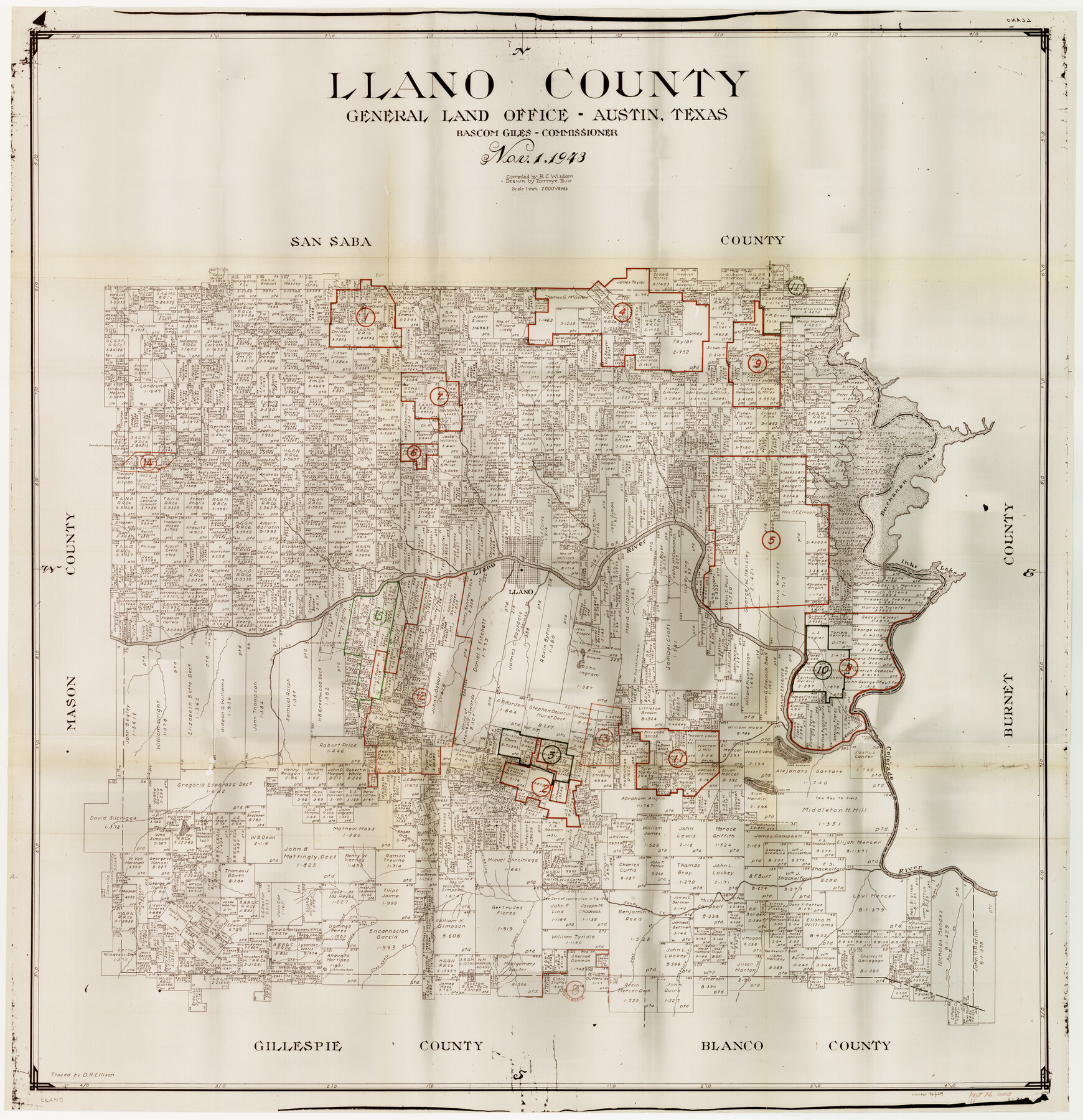
Llano County Working Sketch Graphic Index
-
Map/Doc
76624
-
Collection
General Map Collection
-
Object Dates
11/1/1943 (Creation Date)
-
People and Organizations
R.C. Wisdom (Compiler)
Tommye Buie (Draftsman)
-
Counties
Llano
-
Subjects
County Surveying Working Sketch
-
Height x Width
43.7 x 42.6 inches
111.0 x 108.2 cm
-
Scale
1" = 2000 varas
Part of: General Map Collection
Baylor County

Print $20.00
- Digital $50.00
Baylor County
1961
Size 40.6 x 33.0 inches
Map/Doc 77209
Galveston County Sketch File 44

Print $20.00
- Digital $50.00
Galveston County Sketch File 44
1959
Size 25.2 x 38.8 inches
Map/Doc 10456
Fractional Township No. 7 South Range No. 1 West of the Indian Meridian, Indian Territory

Print $20.00
- Digital $50.00
Fractional Township No. 7 South Range No. 1 West of the Indian Meridian, Indian Territory
1898
Size 19.2 x 24.4 inches
Map/Doc 75197

Orange County Working Sketch 6

Print $20.00
- Digital $50.00
Orange County Working Sketch 6
1922
Size 16.2 x 20.1 inches
Map/Doc 71338
Hood County Sketch File 6

Print $4.00
- Digital $50.00
Hood County Sketch File 6
Size 7.2 x 6.1 inches
Map/Doc 26579
Right of Way and Track Map International & Gt Northern Ry. operated by the International & Gt. Northern Ry. Co., San Antonio Division

Print $40.00
- Digital $50.00
Right of Way and Track Map International & Gt Northern Ry. operated by the International & Gt. Northern Ry. Co., San Antonio Division
1917
Size 25.5 x 57.3 inches
Map/Doc 64589
Randall County Working Sketch 3

Print $40.00
- Digital $50.00
Randall County Working Sketch 3
1934
Size 48.8 x 42.5 inches
Map/Doc 71840
Uvalde County Sketch File 21

Print $8.00
- Digital $50.00
Uvalde County Sketch File 21
1882
Size 14.2 x 8.8 inches
Map/Doc 39004
Kimble County Sketch File 31

Print $20.00
- Digital $50.00
Kimble County Sketch File 31
1890
Size 26.0 x 24.3 inches
Map/Doc 11929
Hill County Sketch File 21a

Print $4.00
- Digital $50.00
Hill County Sketch File 21a
1887
Size 10.8 x 8.4 inches
Map/Doc 26503
King County Rolled Sketch 8

Print $20.00
- Digital $50.00
King County Rolled Sketch 8
1902
Size 34.8 x 29.8 inches
Map/Doc 6531
You may also like
Upton County Working Sketch 17

Print $20.00
- Digital $50.00
Upton County Working Sketch 17
1941
Size 36.1 x 22.1 inches
Map/Doc 69513
Flight Mission No. BRA-8M, Frame 70, Jefferson County

Print $20.00
- Digital $50.00
Flight Mission No. BRA-8M, Frame 70, Jefferson County
1953
Size 18.6 x 22.3 inches
Map/Doc 85590
Carte de la Louisiane et du Cours du Mississipi

Print $20.00
- Digital $50.00
Carte de la Louisiane et du Cours du Mississipi
1718
Size 20.6 x 27.3 inches
Map/Doc 93821
English Field Notes of the Spanish Archives - Book 1

English Field Notes of the Spanish Archives - Book 1
1833
Map/Doc 96527
Sketch Showing Original Corners and Connections Affecting Blocks T1, T2, and T3 in Lamb & Castro Counties

Print $20.00
- Digital $50.00
Sketch Showing Original Corners and Connections Affecting Blocks T1, T2, and T3 in Lamb & Castro Counties
Size 26.5 x 46.0 inches
Map/Doc 90405
State Prison Lands in Walker County - Wynne Farm, Goree Farm, Dairy Pasture, Cemetery Tract

Print $20.00
- Digital $50.00
State Prison Lands in Walker County - Wynne Farm, Goree Farm, Dairy Pasture, Cemetery Tract
Size 16.9 x 19.1 inches
Map/Doc 62994
Shelby County Rolled Sketch 21

Print $20.00
- Digital $50.00
Shelby County Rolled Sketch 21
Size 17.0 x 22.3 inches
Map/Doc 93285
[Sketch showing Capitol Lands]
![89725, [Sketch showing Capitol Lands], Twichell Survey Records](https://historictexasmaps.com/wmedia_w700/maps/89725-1.tif.jpg)
Print $40.00
- Digital $50.00
[Sketch showing Capitol Lands]
Size 38.3 x 72.0 inches
Map/Doc 89725
General Highway Map, Midland County, Texas

Print $20.00
General Highway Map, Midland County, Texas
1961
Size 18.2 x 24.6 inches
Map/Doc 79596
Brewster County Rolled Sketch 122

Print $20.00
- Digital $50.00
Brewster County Rolled Sketch 122
1974
Size 33.4 x 24.8 inches
Map/Doc 5296
Tarrant County Sketch File 10

Print $8.00
- Digital $50.00
Tarrant County Sketch File 10
1859
Size 12.9 x 8.4 inches
Map/Doc 37694
Glasscock County Rolled Sketch 5

Print $20.00
- Digital $50.00
Glasscock County Rolled Sketch 5
1944
Size 41.4 x 33.7 inches
Map/Doc 6016