Uvalde County Sketch File 21
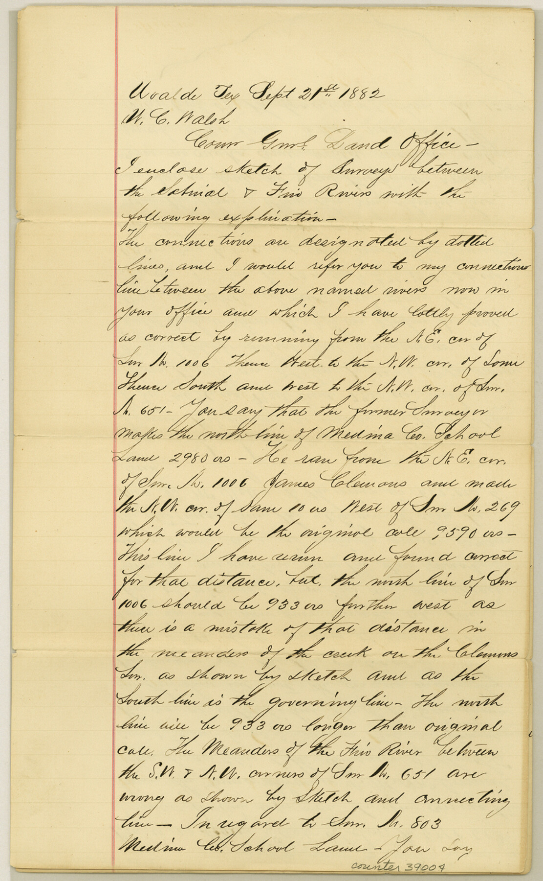
[Explanation regarding connections of surveys 1006 and 651 between the Frio and Sabinal Rivers northeast from Uvalde]
-
Map/Doc
39004
-
Collection
General Map Collection
-
Object Dates
9/21/1882 (Creation Date)
10/2/1882 (File Date)
-
People and Organizations
E.B. Chandler (Surveyor/Engineer)
-
Counties
Uvalde
-
Subjects
Surveying Sketch File
-
Height x Width
14.2 x 8.8 inches
36.1 x 22.4 cm
-
Features
Frio River
Sabinal River
Part of: General Map Collection
Zapata County Rolled Sketch 12B

Print $40.00
- Digital $50.00
Zapata County Rolled Sketch 12B
1917
Size 55.7 x 40.0 inches
Map/Doc 10166
Martin County Rolled Sketch 6

Print $20.00
- Digital $50.00
Martin County Rolled Sketch 6
Size 25.8 x 26.9 inches
Map/Doc 6666
Bandera County Working Sketch 28

Print $20.00
- Digital $50.00
Bandera County Working Sketch 28
1953
Size 24.8 x 19.5 inches
Map/Doc 67624
Liberty County Working Sketch 79

Print $40.00
- Digital $50.00
Liberty County Working Sketch 79
1981
Size 63.7 x 41.4 inches
Map/Doc 70539
Aransas County Sketch File 2

Print $4.00
- Digital $50.00
Aransas County Sketch File 2
Size 7.4 x 5.0 inches
Map/Doc 13100
Foard County Boundary File 2a

Print $40.00
- Digital $50.00
Foard County Boundary File 2a
Size 33.2 x 14.7 inches
Map/Doc 53514
Marion County Working Sketch 12a

Print $20.00
- Digital $50.00
Marion County Working Sketch 12a
1953
Size 23.9 x 33.2 inches
Map/Doc 70788
Shores of Nueces Bay, Texas

Print $40.00
- Digital $50.00
Shores of Nueces Bay, Texas
1882
Size 33.0 x 54.3 inches
Map/Doc 73464
McMullen County Rolled Sketch 9

Print $20.00
- Digital $50.00
McMullen County Rolled Sketch 9
Size 34.4 x 40.9 inches
Map/Doc 6726
Castro County Sketch File 4f

Print $4.00
- Digital $50.00
Castro County Sketch File 4f
Size 13.8 x 8.9 inches
Map/Doc 17475
Taylor County Rolled Sketch 30

Print $20.00
- Digital $50.00
Taylor County Rolled Sketch 30
1999
Size 29.7 x 29.7 inches
Map/Doc 7923

You may also like
Jim Hogg County Sketch File 8

Print $20.00
- Digital $50.00
Jim Hogg County Sketch File 8
1941
Size 21.9 x 27.0 inches
Map/Doc 11887
Current Miscellaneous File 42

Print $4.00
- Digital $50.00
Current Miscellaneous File 42
Size 11.2 x 8.7 inches
Map/Doc 73981
Montague County Working Sketch 29

Print $20.00
- Digital $50.00
Montague County Working Sketch 29
1972
Size 27.8 x 22.1 inches
Map/Doc 71095
Hudspeth County Sketch File 18

Print $6.00
- Digital $50.00
Hudspeth County Sketch File 18
1935
Size 11.2 x 8.7 inches
Map/Doc 26959
Jasper County Rolled Sketch 2

Print $20.00
- Digital $50.00
Jasper County Rolled Sketch 2
1941
Size 22.5 x 16.6 inches
Map/Doc 6348
Working Sketch in Hutchinson County

Print $2.00
- Digital $50.00
Working Sketch in Hutchinson County
1898
Size 8.7 x 15.4 inches
Map/Doc 92975
Kleberg County, Cayo del Grullo

Print $20.00
- Digital $50.00
Kleberg County, Cayo del Grullo
1952
Size 32.6 x 29.0 inches
Map/Doc 73506
Flight Mission No. CUG-1P, Frame 83, Kleberg County

Print $20.00
- Digital $50.00
Flight Mission No. CUG-1P, Frame 83, Kleberg County
1956
Size 18.5 x 22.2 inches
Map/Doc 86148
Sketch of the route from the camp on the Concho River to Phantom Hill, Texas

Print $20.00
- Digital $50.00
Sketch of the route from the camp on the Concho River to Phantom Hill, Texas
1852
Size 30.0 x 11.9 inches
Map/Doc 2005
Lindner Subdivision out of the Baker Subdivision of the Cucharia Tract being Lots 11 and 14, San Salvador del Tule Grant Hidalgo Co. Texas and also showing the Ehlert-Krausse Sub. and the Townsite of Alsonia

Print $20.00
- Digital $50.00
Lindner Subdivision out of the Baker Subdivision of the Cucharia Tract being Lots 11 and 14, San Salvador del Tule Grant Hidalgo Co. Texas and also showing the Ehlert-Krausse Sub. and the Townsite of Alsonia
1927
Size 22.3 x 35.3 inches
Map/Doc 77093
Hardeman County Rolled Sketch 15

Print $20.00
- Digital $50.00
Hardeman County Rolled Sketch 15
1890
Size 18.0 x 23.0 inches
Map/Doc 6072
General Highway Map of Garza County, Texas

Print $20.00
- Digital $50.00
General Highway Map of Garza County, Texas
1950
Size 25.9 x 18.8 inches
Map/Doc 92646