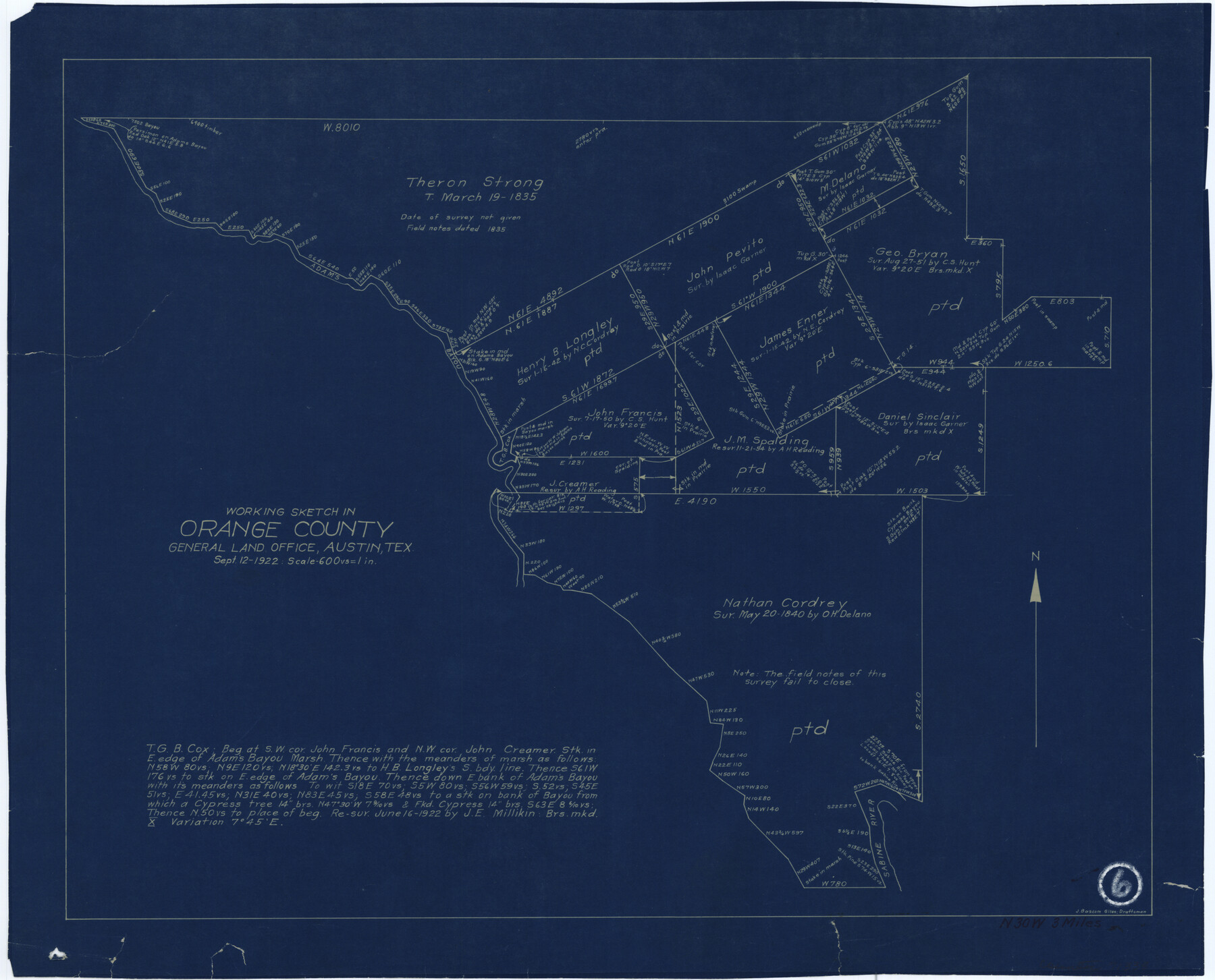
Orange County Working Sketch 6
-
Map/Doc
71338
-
Collection
General Map Collection
-
Object Dates
9/12/1922 (Creation Date)
-
People and Organizations
J. Bascom Giles (Draftsman)
-
Counties
Orange
-
Subjects
Surveying Working Sketch
-
Height x Width
16.2 x 20.1 inches
41.2 x 51.1 cm
-
Scale
1" = 600 varas
Part of: General Map Collection
Nueces County Sketch File 67

Print $4.00
- Digital $50.00
Nueces County Sketch File 67
Size 11.1 x 8.7 inches
Map/Doc 32998
Crockett County Rolled Sketch 57

Print $40.00
- Digital $50.00
Crockett County Rolled Sketch 57
1944
Size 52.7 x 28.0 inches
Map/Doc 8719
Texas 1972 Official Highway Travel Map

Digital $50.00
Texas 1972 Official Highway Travel Map
Size 27.9 x 36.0 inches
Map/Doc 94313
United States of America compiled from the latest & best Authorities

Print $20.00
- Digital $50.00
United States of America compiled from the latest & best Authorities
1818
Size 17.3 x 20.9 inches
Map/Doc 97135
Grayson County Working Sketch 7

Print $20.00
- Digital $50.00
Grayson County Working Sketch 7
1940
Size 41.1 x 27.7 inches
Map/Doc 63246
Webb County Working Sketch 58

Print $20.00
- Digital $50.00
Webb County Working Sketch 58
1958
Size 37.4 x 37.0 inches
Map/Doc 72424
Nueces County NRC Article 33.136 Sketch 18

Print $74.00
- Digital $50.00
Nueces County NRC Article 33.136 Sketch 18
2014
Size 22.0 x 34.0 inches
Map/Doc 94714
Flight Mission No. DAG-21K, Frame 117, Matagorda County

Print $20.00
- Digital $50.00
Flight Mission No. DAG-21K, Frame 117, Matagorda County
1952
Size 18.5 x 22.4 inches
Map/Doc 86440
Map Showing Part of the Blue Ridge Farm of the Texas Prison System, Fort Bend County, Texas

Print $20.00
- Digital $50.00
Map Showing Part of the Blue Ridge Farm of the Texas Prison System, Fort Bend County, Texas
Size 22.2 x 36.2 inches
Map/Doc 62979
Midland County Working Sketch 19

Print $20.00
- Digital $50.00
Midland County Working Sketch 19
1953
Size 29.9 x 24.7 inches
Map/Doc 70999
Coke County Sketch File 21

Print $20.00
- Digital $50.00
Coke County Sketch File 21
1911
Size 12.6 x 14.0 inches
Map/Doc 18614
Kleberg County Rolled Sketch 10-32

Print $20.00
- Digital $50.00
Kleberg County Rolled Sketch 10-32
1952
Size 36.2 x 34.5 inches
Map/Doc 9369
You may also like
Leon County Sketch File 20

Print $6.00
- Digital $50.00
Leon County Sketch File 20
Size 10.6 x 10.0 inches
Map/Doc 29770
Matagorda County Boundary File 1a

Print $8.00
- Digital $50.00
Matagorda County Boundary File 1a
Size 14.2 x 8.6 inches
Map/Doc 56889
Brazos River Conservation and Reclamation District Official Boundary Line Survey

Print $20.00
- Digital $50.00
Brazos River Conservation and Reclamation District Official Boundary Line Survey
Size 37.3 x 24.7 inches
Map/Doc 90129
Navigation Maps of Gulf Intracoastal Waterway, Port Arthur to Brownsville, Texas

Print $4.00
- Digital $50.00
Navigation Maps of Gulf Intracoastal Waterway, Port Arthur to Brownsville, Texas
1951
Size 16.7 x 21.5 inches
Map/Doc 65443
Johnson County Working Sketch 23

Print $20.00
- Digital $50.00
Johnson County Working Sketch 23
1997
Size 25.3 x 22.8 inches
Map/Doc 66636
Flight Mission No. BRA-17M, Frame 2, Jefferson County

Print $20.00
- Digital $50.00
Flight Mission No. BRA-17M, Frame 2, Jefferson County
1953
Size 18.6 x 22.3 inches
Map/Doc 85782
Flight Mission No. DQN-1K, Frame 141, Calhoun County

Print $20.00
- Digital $50.00
Flight Mission No. DQN-1K, Frame 141, Calhoun County
1953
Size 18.5 x 22.1 inches
Map/Doc 84204

Cherokee County Working Sketch 5

Print $20.00
- Digital $50.00
Cherokee County Working Sketch 5
1951
Size 22.0 x 23.5 inches
Map/Doc 67960
Culberson County Working Sketch 14

Print $20.00
- Digital $50.00
Culberson County Working Sketch 14
1923
Size 17.9 x 19.2 inches
Map/Doc 68466
Harris County Rolled Sketch P58

Print $20.00
- Digital $50.00
Harris County Rolled Sketch P58
1929
Size 29.4 x 37.7 inches
Map/Doc 9119
Kinney County Sketch File 21

Print $50.00
- Digital $50.00
Kinney County Sketch File 21
1887
Size 14.4 x 8.8 inches
Map/Doc 29135