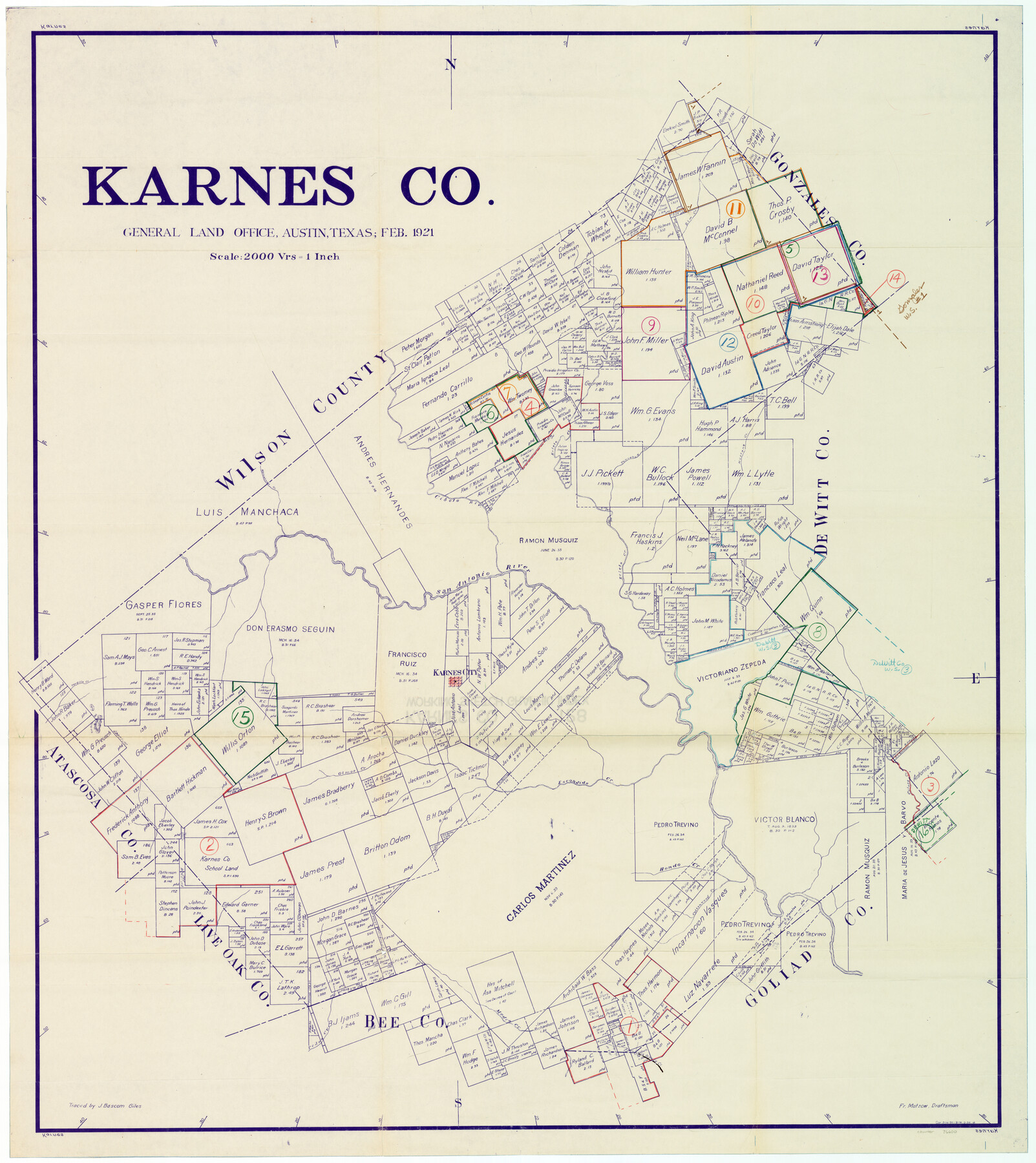
Karnes County Working Sketch Graphic Index
-
Map/Doc
76600
-
Collection
General Map Collection
-
Object Dates
2/1921 (Creation Date)
-
People and Organizations
Fr. Matzow (Draftsman)
J. Bascom Giles (Tracer)
-
Counties
Karnes
-
Subjects
County Surveying Working Sketch
-
Height x Width
45.0 x 40.3 inches
114.3 x 102.4 cm
-
Scale
1" = 2000 varas
Part of: General Map Collection
Duval County Sketch File 15

Print $4.00
- Digital $50.00
Duval County Sketch File 15
Size 12.0 x 9.0 inches
Map/Doc 21309
Hardeman County

Print $20.00
- Digital $50.00
Hardeman County
1935
Size 46.0 x 42.7 inches
Map/Doc 95520
Bailey County Working Sketch 1

Print $20.00
- Digital $50.00
Bailey County Working Sketch 1
1920
Size 28.9 x 10.5 inches
Map/Doc 67588
Loving County Working Sketch 23

Print $20.00
- Digital $50.00
Loving County Working Sketch 23
1952
Size 15.1 x 31.5 inches
Map/Doc 70657
Montgomery County

Print $20.00
- Digital $50.00
Montgomery County
1901
Size 42.2 x 47.4 inches
Map/Doc 66939
Kenedy County Rolled Sketch 11

Print $20.00
- Digital $50.00
Kenedy County Rolled Sketch 11
1938
Size 40.5 x 30.2 inches
Map/Doc 6471
Val Verde County Rolled Sketch 36

Print $40.00
- Digital $50.00
Val Verde County Rolled Sketch 36
Size 49.6 x 43.7 inches
Map/Doc 10072
Lubbock County Working Sketch 1

Print $20.00
- Digital $50.00
Lubbock County Working Sketch 1
Size 8.7 x 35.3 inches
Map/Doc 70660
DeWitt County Sketch File 11

Print $20.00
- Digital $50.00
DeWitt County Sketch File 11
1851
Size 24.5 x 35.2 inches
Map/Doc 11314
Right of Way and Track Map, the Missouri, Kansas and Texas Ry. of Texas operated by the Missouri, Kansas and Texas Ry. of Texas, San Antonio Division

Print $40.00
- Digital $50.00
Right of Way and Track Map, the Missouri, Kansas and Texas Ry. of Texas operated by the Missouri, Kansas and Texas Ry. of Texas, San Antonio Division
1918
Size 25.1 x 57.7 inches
Map/Doc 64585
Map of Zapata County

Print $20.00
- Digital $50.00
Map of Zapata County
1879
Size 27.4 x 25.6 inches
Map/Doc 4176
Reeves County Working Sketch 62

Print $20.00
- Digital $50.00
Reeves County Working Sketch 62
1984
Size 29.5 x 35.4 inches
Map/Doc 63505
You may also like
San Jacinto County Rolled Sketch 10A

Print $40.00
- Digital $50.00
San Jacinto County Rolled Sketch 10A
1944
Size 42.9 x 59.0 inches
Map/Doc 9882
Grayson County Working Sketch 11

Print $20.00
- Digital $50.00
Grayson County Working Sketch 11
1951
Size 27.9 x 24.3 inches
Map/Doc 63250
Flight Mission No. BRA-16M, Frame 106, Jefferson County

Print $20.00
- Digital $50.00
Flight Mission No. BRA-16M, Frame 106, Jefferson County
1953
Size 18.6 x 22.3 inches
Map/Doc 85718
[Miller Day Ranch]
![81517, [Miller Day Ranch], General Map Collection](https://historictexasmaps.com/wmedia_w700/maps/81517.tif.jpg)
Print $40.00
- Digital $50.00
[Miller Day Ranch]
1995
Size 60.6 x 38.0 inches
Map/Doc 81517
Cameron County Rolled Sketch 20A

Print $20.00
- Digital $50.00
Cameron County Rolled Sketch 20A
Size 12.5 x 23.1 inches
Map/Doc 5471
General Highway Map, Potter County, Texas

Print $20.00
General Highway Map, Potter County, Texas
1961
Size 24.5 x 18.2 inches
Map/Doc 79631
Baylor County Sketch File 21

Print $40.00
- Digital $50.00
Baylor County Sketch File 21
Size 17.5 x 30.7 inches
Map/Doc 10908
Deaf Smith County Sketch File 1 1/2

Print $20.00
- Digital $50.00
Deaf Smith County Sketch File 1 1/2
Size 20.7 x 17.1 inches
Map/Doc 11302
Val Verde County Working Sketch 96

Print $20.00
- Digital $50.00
Val Verde County Working Sketch 96
1979
Size 38.9 x 36.9 inches
Map/Doc 72231
Llano County Sketch File 15

Print $2.00
- Digital $50.00
Llano County Sketch File 15
Size 10.4 x 7.7 inches
Map/Doc 30391
Edwards County Working Sketch 106

Print $20.00
- Digital $50.00
Edwards County Working Sketch 106
1972
Size 32.3 x 26.5 inches
Map/Doc 68982
Lampasas County Working Sketch 6

Print $20.00
- Digital $50.00
Lampasas County Working Sketch 6
1950
Size 29.5 x 20.6 inches
Map/Doc 70283