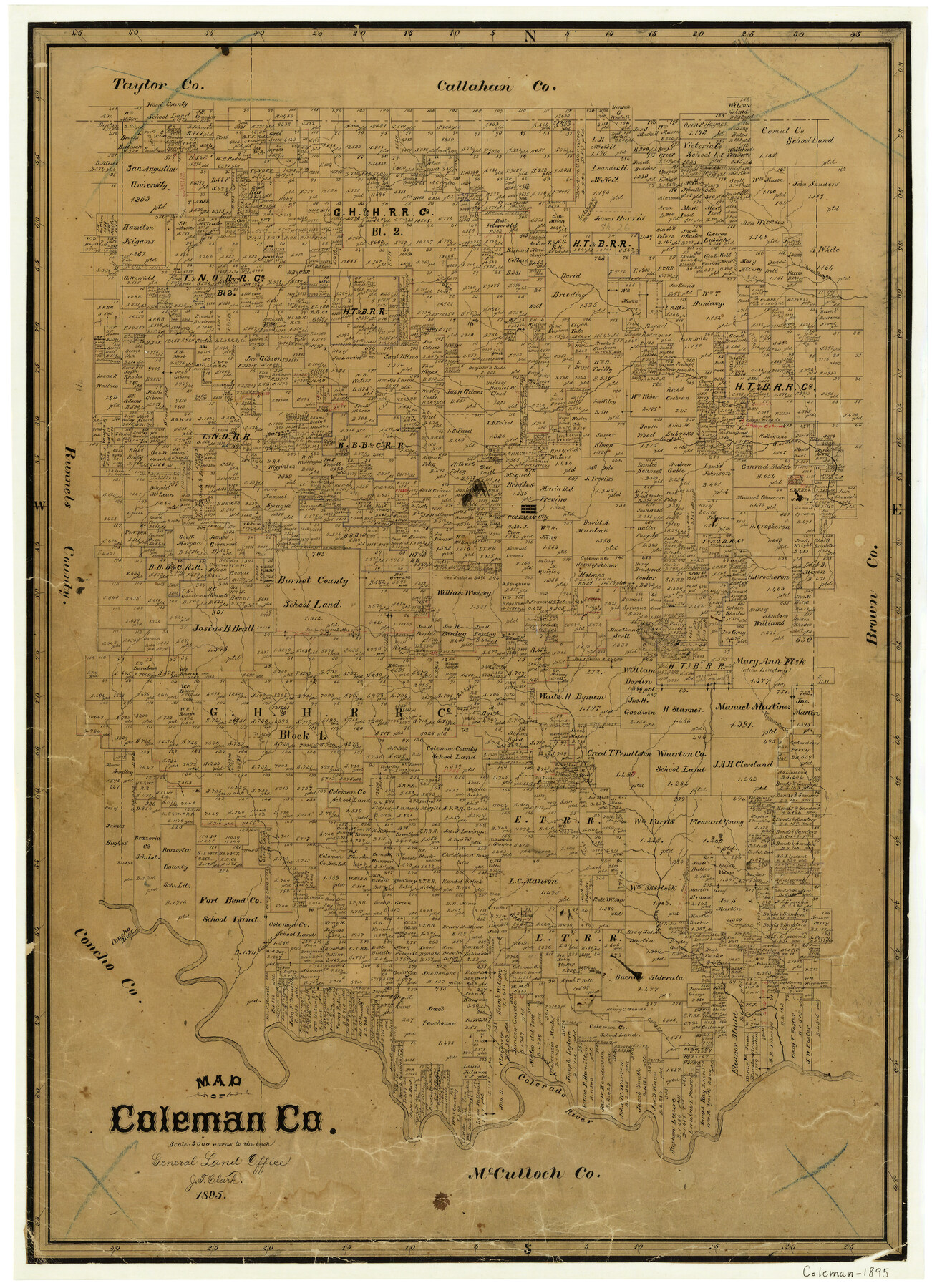
Map of Coleman County
-
Map/Doc
3415
-
Collection
General Map Collection
-
Object Dates
1895 (Creation Date)
-
People and Organizations
Texas General Land Office (Publisher)
J.F. Clark (Draftsman)
-
Counties
Coleman
-
Subjects
County
-
Height x Width
26.1 x 18.9 inches
66.3 x 48.0 cm
-
Features
South Jim Ned Creek
Robinsons Peak
Jim Ned Creek
Hords Creek
Coleman City
Santa Anna's Peak
Mukewater Creek
Concho River
Elm Creek
Urania Creek
Home Creek
Camp Creek
Davids Creek
Colorado River
Bull Creek
Pecan Bayou
Part of: General Map Collection
Aransas County Sketch File 14

Print $36.00
- Digital $50.00
Aransas County Sketch File 14
1891
Size 14.0 x 8.5 inches
Map/Doc 13128
El Paso County Rolled Sketch Z55

Print $40.00
- Digital $50.00
El Paso County Rolled Sketch Z55
1915
Size 36.8 x 49.4 inches
Map/Doc 8870
Webb County Rolled Sketch 22

Print $40.00
- Digital $50.00
Webb County Rolled Sketch 22
Size 108.0 x 43.7 inches
Map/Doc 10120

Map of Brazoria

Print $20.00
- Digital $50.00
Map of Brazoria
1863
Size 27.4 x 27.3 inches
Map/Doc 1013
Maverick County Rolled Sketch 21

Print $20.00
- Digital $50.00
Maverick County Rolled Sketch 21
Size 24.6 x 28.6 inches
Map/Doc 6713
Sketch of surveys in Harrison & Marion Cos. Showing Caddo Lake & Subdivisions

Print $20.00
- Digital $50.00
Sketch of surveys in Harrison & Marion Cos. Showing Caddo Lake & Subdivisions
1955
Size 33.8 x 32.4 inches
Map/Doc 93284
Gillespie County

Print $40.00
- Digital $50.00
Gillespie County
1945
Size 39.7 x 48.4 inches
Map/Doc 73157
Upton County Rolled Sketch 33

Print $20.00
- Digital $50.00
Upton County Rolled Sketch 33
1951
Size 39.2 x 33.0 inches
Map/Doc 8076
Duval County Working Sketch 6

Print $20.00
- Digital $50.00
Duval County Working Sketch 6
1935
Size 26.9 x 21.8 inches
Map/Doc 68719
Jefferson County Rolled Sketch GA

Print $20.00
- Digital $50.00
Jefferson County Rolled Sketch GA
1937
Size 29.5 x 36.7 inches
Map/Doc 6437
Flight Mission No. CRC-4R, Frame 100, Chambers County

Print $20.00
- Digital $50.00
Flight Mission No. CRC-4R, Frame 100, Chambers County
1956
Size 18.5 x 22.2 inches
Map/Doc 84897
You may also like
Bexar County State Real Property Sketch 2

Print $40.00
- Digital $50.00
Bexar County State Real Property Sketch 2
1997
Size 25.6 x 38.7 inches
Map/Doc 61701
General Highway Map, Houston County, Texas

Print $20.00
General Highway Map, Houston County, Texas
1940
Size 25.0 x 18.6 inches
Map/Doc 79132
Brazoria County Sketch File 5

Print $4.00
- Digital $50.00
Brazoria County Sketch File 5
1862
Size 13.1 x 8.1 inches
Map/Doc 14929
Upton County Rolled Sketch 24

Print $20.00
- Digital $50.00
Upton County Rolled Sketch 24
1886
Size 17.3 x 43.5 inches
Map/Doc 10043

Flight Mission No. DCL-7C, Frame 27, Kenedy County

Print $20.00
- Digital $50.00
Flight Mission No. DCL-7C, Frame 27, Kenedy County
1943
Size 15.4 x 15.2 inches
Map/Doc 86019
Erath County Working Sketch 47

Print $20.00
- Digital $50.00
Erath County Working Sketch 47
1984
Size 16.3 x 18.3 inches
Map/Doc 69128
C.C. Slaughter's Running Water Ranch situated in Hale and Lamb Counties

Print $20.00
- Digital $50.00
C.C. Slaughter's Running Water Ranch situated in Hale and Lamb Counties
Size 26.5 x 18.8 inches
Map/Doc 91050
Flight Mission No. CUG-2P, Frame 7, Kleberg County

Print $20.00
- Digital $50.00
Flight Mission No. CUG-2P, Frame 7, Kleberg County
1956
Size 18.5 x 22.3 inches
Map/Doc 86179
Brewster County Rolled Sketch C

Print $40.00
- Digital $50.00
Brewster County Rolled Sketch C
Size 39.0 x 71.8 inches
Map/Doc 8466
Magnolia Road Map of Texas

Print $20.00
Magnolia Road Map of Texas
1933
Size 18.1 x 24.1 inches
Map/Doc 76301
Kimble County Working Sketch 73

Print $20.00
- Digital $50.00
Kimble County Working Sketch 73
1966
Size 21.3 x 18.5 inches
Map/Doc 70141