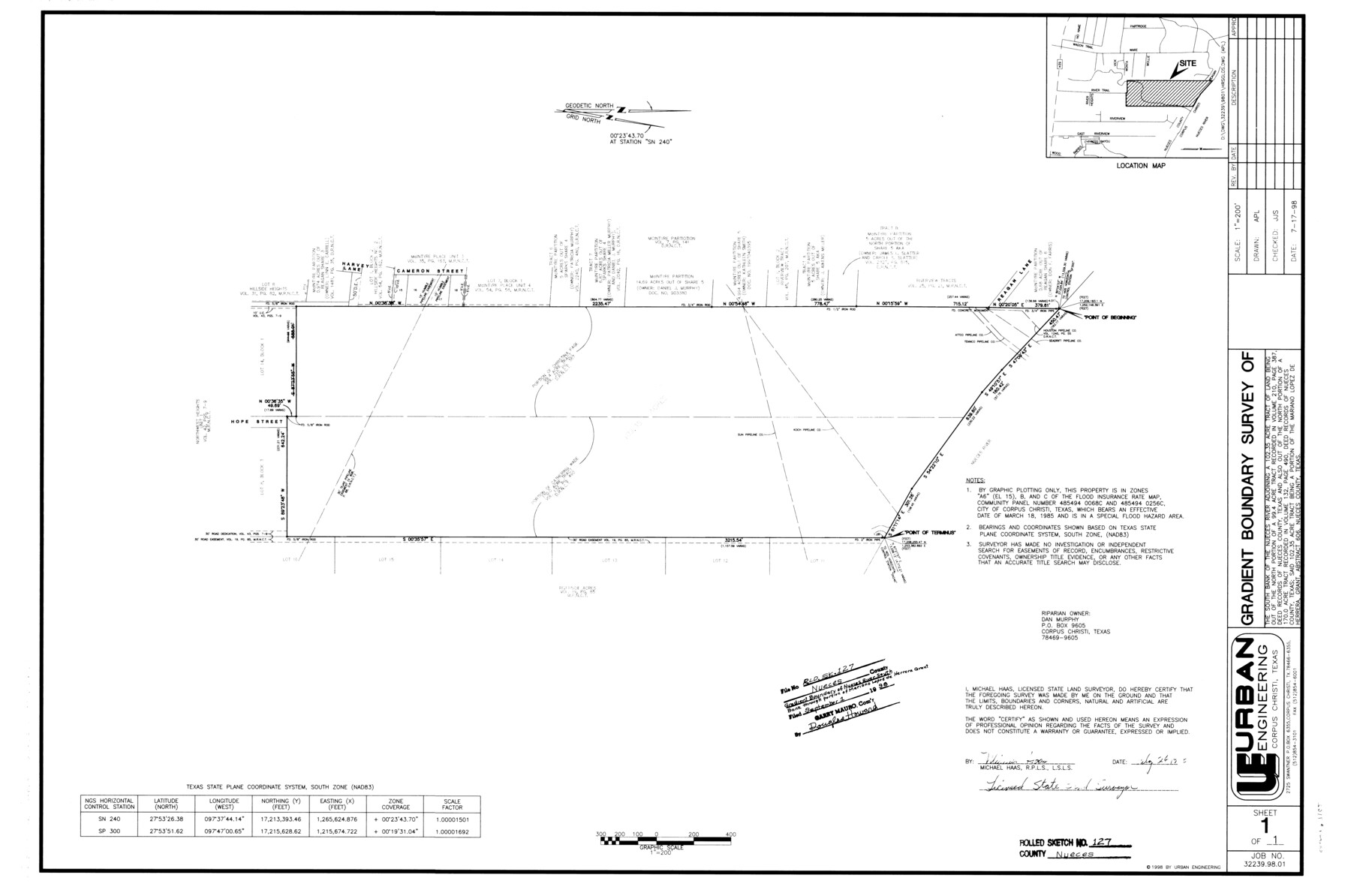
Nueces County Rolled Sketch 127
Gradient boundary survey of the south bank of the Nueces River adjoining a 102.35 acre tract of land being out of the north portion of a 99.4 acre tract and also out of the north portion of a 170 acre tract
-
Map/Doc
7162
-
Collection
General Map Collection
-
Object Dates
1998/9/1 (File Date)
1998/7/17 (Creation Date)
-
People and Organizations
Michael Haas (Surveyor/Engineer)
-
Counties
Nueces
-
Subjects
Surveying Rolled Sketch
-
Height x Width
24.1 x 36.4 inches
61.2 x 92.5 cm
-
Medium
mylar, print
-
Scale
1" = 200 feet
-
Comments
See Nueces County Rolled Sketch 127 A-F (8976) for surveyor's report and correspondence.
Related maps
Nueces County Rolled Sketch 127 A-F

Print $22.00
Nueces County Rolled Sketch 127 A-F
1998
Size 11.1 x 26.6 inches
Map/Doc 8976
Part of: General Map Collection
General Chart of the Coast No. XXI Gulf Coast from Galveston to the Rio Grande

Print $20.00
- Digital $50.00
General Chart of the Coast No. XXI Gulf Coast from Galveston to the Rio Grande
1883
Size 27.1 x 18.4 inches
Map/Doc 72729
Bee County Sketch File 13

Print $4.00
- Digital $50.00
Bee County Sketch File 13
1876
Size 12.6 x 8.1 inches
Map/Doc 14295
Kaufman County Boundary File 6a

Print $6.00
- Digital $50.00
Kaufman County Boundary File 6a
Size 14.0 x 8.5 inches
Map/Doc 55963
Lubbock County Sketch File 15

Print $6.00
- Digital $50.00
Lubbock County Sketch File 15
1902
Size 11.2 x 8.8 inches
Map/Doc 30440
El Paso County State Real Property Sketch 4

Print $20.00
- Digital $50.00
El Paso County State Real Property Sketch 4
2012
Size 29.9 x 35.9 inches
Map/Doc 93701
The United States and the Relative Position of the Oregon and Texas

Print $20.00
- Digital $50.00
The United States and the Relative Position of the Oregon and Texas
1850
Size 16.8 x 23.1 inches
Map/Doc 93666
Palo Pinto County Working Sketch 6

Print $20.00
- Digital $50.00
Palo Pinto County Working Sketch 6
1921
Map/Doc 71389
Report of Construction re: MA 46948, H. C. Henson

Print $2.00
- Digital $50.00
Report of Construction re: MA 46948, H. C. Henson
1954
Size 11.1 x 8.9 inches
Map/Doc 62571
Jefferson County Rolled Sketch 27

Print $20.00
- Digital $50.00
Jefferson County Rolled Sketch 27
1948
Size 24.2 x 46.6 inches
Map/Doc 9292
Leon County Sketch File 31

Print $20.00
- Digital $50.00
Leon County Sketch File 31
Size 19.1 x 20.5 inches
Map/Doc 11993
Presidio County Working Sketch 52

Print $20.00
- Digital $50.00
Presidio County Working Sketch 52
1954
Size 46.5 x 27.6 inches
Map/Doc 71729
Matagorda County NRC Article 33.136 Sketch 13

Print $22.00
- Digital $50.00
Matagorda County NRC Article 33.136 Sketch 13
Size 24.2 x 36.0 inches
Map/Doc 95720
You may also like
McMullen County Sketch File 44

Print $6.00
- Digital $50.00
McMullen County Sketch File 44
1942
Size 14.2 x 8.8 inches
Map/Doc 31426
Harris County Working Sketch 29

Print $20.00
- Digital $50.00
Harris County Working Sketch 29
1934
Size 22.6 x 30.5 inches
Map/Doc 65921
Galveston County NRC Article 33.136 Sketch 5

Print $20.00
- Digital $50.00
Galveston County NRC Article 33.136 Sketch 5
2001
Size 23.5 x 19.1 inches
Map/Doc 61587
Working Sketch, Garza County

Print $20.00
- Digital $50.00
Working Sketch, Garza County
1904
Size 13.9 x 14.7 inches
Map/Doc 92693
Nueces County Working Sketch 7

Print $40.00
- Digital $50.00
Nueces County Working Sketch 7
1972
Size 26.9 x 72.6 inches
Map/Doc 71309

Flight Mission No. DCL-7C, Frame 4, Kenedy County

Print $20.00
- Digital $50.00
Flight Mission No. DCL-7C, Frame 4, Kenedy County
1943
Size 18.6 x 22.3 inches
Map/Doc 85996
Comal County Sketch File 5

Print $4.00
- Digital $50.00
Comal County Sketch File 5
1848
Size 12.9 x 8.4 inches
Map/Doc 19006

[Map showing T&P Lands in El Paso County]
![88936, [Map showing T&P Lands in El Paso County], Library of Congress](https://historictexasmaps.com/wmedia_w700/maps/88936.tif.jpg)
Print $20.00
[Map showing T&P Lands in El Paso County]
Size 22.6 x 17.5 inches
Map/Doc 88936
Armstrong County Working Sketch 4

Print $20.00
- Digital $50.00
Armstrong County Working Sketch 4
1918
Size 23.9 x 32.0 inches
Map/Doc 67235
Jeff Davis County Rolled Sketch T4

Print $20.00
- Digital $50.00
Jeff Davis County Rolled Sketch T4
Size 28.9 x 23.9 inches
Map/Doc 6382