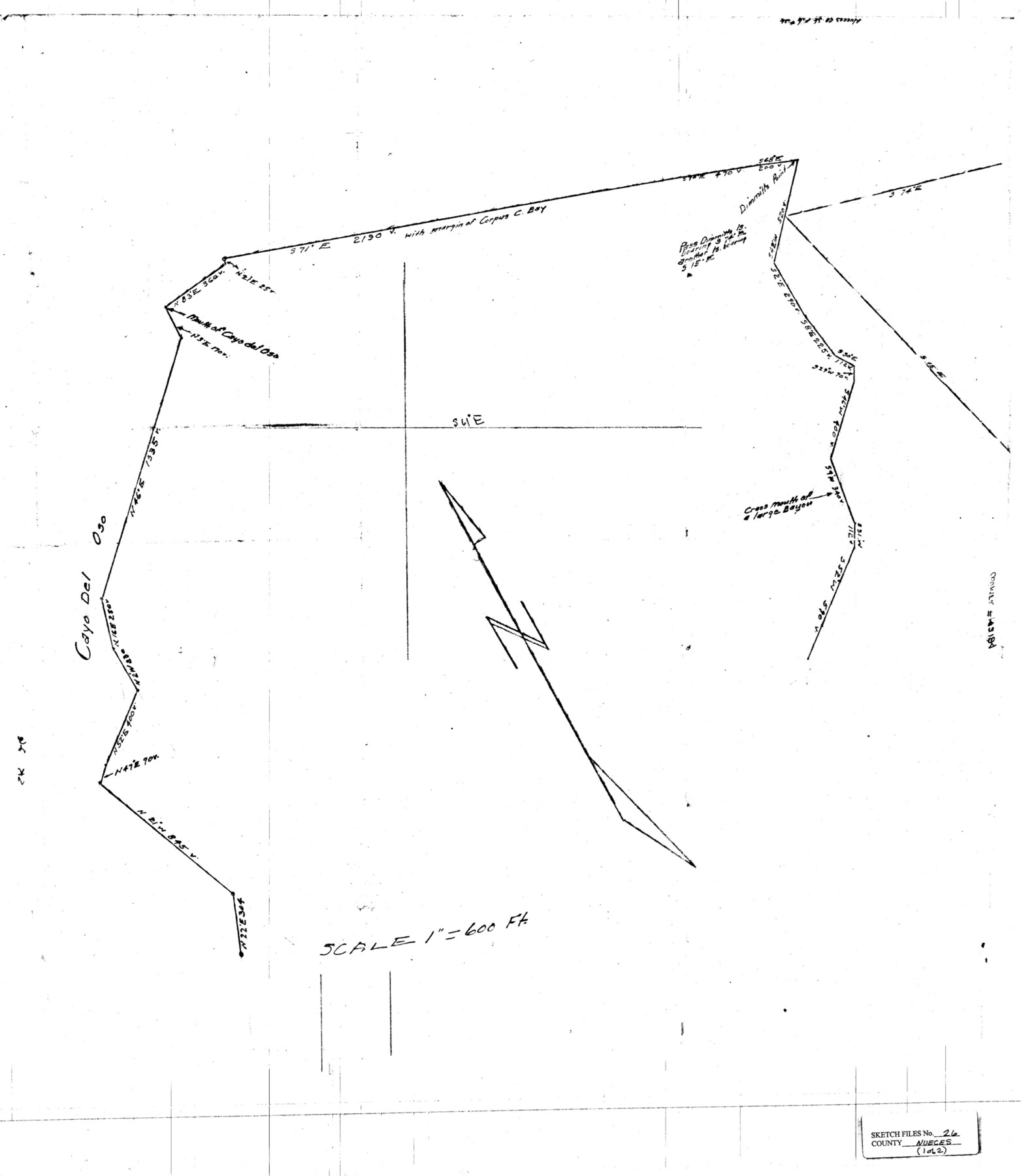
Nueces County Sketch File 26
[Two sketches showing area around Laguna Madre]
-
Map/Doc
42184
-
Collection
General Map Collection
-
Object Dates
11/13/1890 (Creation Date)
11/13/1890 (Survey Date)
-
People and Organizations
C.H. Butts (Surveyor/Engineer)
-
Counties
Nueces
-
Subjects
Surveying Sketch File
-
Height x Width
26.7 x 23.2 inches
67.8 x 58.9 cm
-
Medium
multi-page, multi-format
-
Scale
1" = 600'
-
Features
La Amargesa [Creek]
Cayo del Infiernillo
El Grullo [Lake]
Santa Gertrudis Creek
Tranquitas [Creek]
Road to Brownsville
Road to Rio Grande City
Callo de los Laurelos
Callo del Oso
Road to Laredo
Santa Petronila [Creek]
Agua Dulce [Creek]
San Fernando Creek
(Old) Road to Brownsville
San Diego [Creek]
Chiltipin Creek
Corpus Christi Bay
Road to Eagle Pass
San Patricio
Nuecestown
Road to San Patricio
Corpus Christi
Corpus Christi Pass
Gulf of Mexico
Padre Island
Laguna Madre
Flour Bluff Point
Mustang Island
Cayo del Oso
Dimmit's Island
Dimmit's Point
Part of: General Map Collection
Denton County Sketch File 5

Print $6.00
- Digital $50.00
Denton County Sketch File 5
1855
Size 9.8 x 8.1 inches
Map/Doc 20693
San Jacinto County Sketch File 16

Print $4.00
San Jacinto County Sketch File 16
1934
Size 11.3 x 8.7 inches
Map/Doc 35729
Cochran County Boundary File 7

Print $6.00
- Digital $50.00
Cochran County Boundary File 7
Size 14.0 x 9.1 inches
Map/Doc 51567
Fractional Township No. 7 South Range No. 20 East of the Indian Meridian, Indian Territory

Print $20.00
- Digital $50.00
Fractional Township No. 7 South Range No. 20 East of the Indian Meridian, Indian Territory
1897
Size 19.2 x 24.2 inches
Map/Doc 75236
Throckmorton Co.

Print $20.00
- Digital $50.00
Throckmorton Co.
1898
Size 41.2 x 35.9 inches
Map/Doc 16895
Reeves County Working Sketch 38

Print $20.00
- Digital $50.00
Reeves County Working Sketch 38
1971
Size 36.4 x 39.0 inches
Map/Doc 63481
Hardeman County Rolled Sketch 14

Print $20.00
- Digital $50.00
Hardeman County Rolled Sketch 14
1884
Size 18.2 x 29.1 inches
Map/Doc 6071
Edwards County Working Sketch 78

Print $20.00
- Digital $50.00
Edwards County Working Sketch 78
1962
Size 26.5 x 22.1 inches
Map/Doc 68954
Duval County Sketch File 20 1/2

Print $4.00
- Digital $50.00
Duval County Sketch File 20 1/2
1880
Size 10.3 x 8.4 inches
Map/Doc 21324
Flight Mission No. BQY-4M, Frame 69, Harris County

Print $20.00
- Digital $50.00
Flight Mission No. BQY-4M, Frame 69, Harris County
1953
Size 18.6 x 22.4 inches
Map/Doc 85278
Location Through GC&SFRRCo., Runnels County, Texas

Print $20.00
- Digital $50.00
Location Through GC&SFRRCo., Runnels County, Texas
1898
Size 21.5 x 32.8 inches
Map/Doc 64509
Chicago & Rock Island

Print $40.00
- Digital $50.00
Chicago & Rock Island
1892
Size 8.4 x 70.7 inches
Map/Doc 64498
You may also like
Brazoria County Working Sketch 32

Print $20.00
- Digital $50.00
Brazoria County Working Sketch 32
1979
Size 15.8 x 36.9 inches
Map/Doc 67517
Flight Mission No. DCL-6C, Frame 123, Kenedy County

Print $20.00
- Digital $50.00
Flight Mission No. DCL-6C, Frame 123, Kenedy County
1943
Size 18.6 x 22.3 inches
Map/Doc 85953
Fractional Township No. 7 South Range No. 1 East of the Indian Meridian, Indian Territory

Print $20.00
- Digital $50.00
Fractional Township No. 7 South Range No. 1 East of the Indian Meridian, Indian Territory
1898
Size 19.2 x 24.6 inches
Map/Doc 75199
[Copy of a portion of] The Coast & Bays of Western Texas, St. Joseph's and Mustang Islands from Actual Survey, the Remainder from County Maps, Etc.
![72770, [Copy of a portion of] The Coast & Bays of Western Texas, St. Joseph's and Mustang Islands from Actual Survey, the Remainder from County Maps, Etc., General Map Collection](https://historictexasmaps.com/wmedia_w700/maps/72770.tif.jpg)
Print $20.00
- Digital $50.00
[Copy of a portion of] The Coast & Bays of Western Texas, St. Joseph's and Mustang Islands from Actual Survey, the Remainder from County Maps, Etc.
1857
Size 25.7 x 18.3 inches
Map/Doc 72770
Zavala County Sketch File 42

Print $20.00
- Digital $50.00
Zavala County Sketch File 42
1915
Size 19.4 x 25.6 inches
Map/Doc 12732
Wilbarger County Sketch File 4

Print $4.00
- Digital $50.00
Wilbarger County Sketch File 4
1883
Size 12.7 x 8.2 inches
Map/Doc 40168
Falls County Boundary File 2

Print $6.00
- Digital $50.00
Falls County Boundary File 2
Size 9.9 x 6.6 inches
Map/Doc 53263
Tyler County Working Sketch 10

Print $20.00
- Digital $50.00
Tyler County Working Sketch 10
1937
Size 24.0 x 24.1 inches
Map/Doc 69480
Cottle County Working Sketch 23

Print $20.00
- Digital $50.00
Cottle County Working Sketch 23
1992
Size 26.6 x 24.2 inches
Map/Doc 68333
Brazoria County Rolled Sketch 25

Print $40.00
- Digital $50.00
Brazoria County Rolled Sketch 25
1935
Size 50.8 x 33.5 inches
Map/Doc 8928
Map of Texas and the Countries Adjacent compiled in the Bureau of the Corps of Topographical Engineers from the Best Authorities

Print $2.00
- Digital $50.00
Map of Texas and the Countries Adjacent compiled in the Bureau of the Corps of Topographical Engineers from the Best Authorities
1844
Size 8.1 x 5.0 inches
Map/Doc 93868
Pecos County Working Sketch 118

Print $20.00
- Digital $50.00
Pecos County Working Sketch 118
1973
Size 46.2 x 36.9 inches
Map/Doc 71591