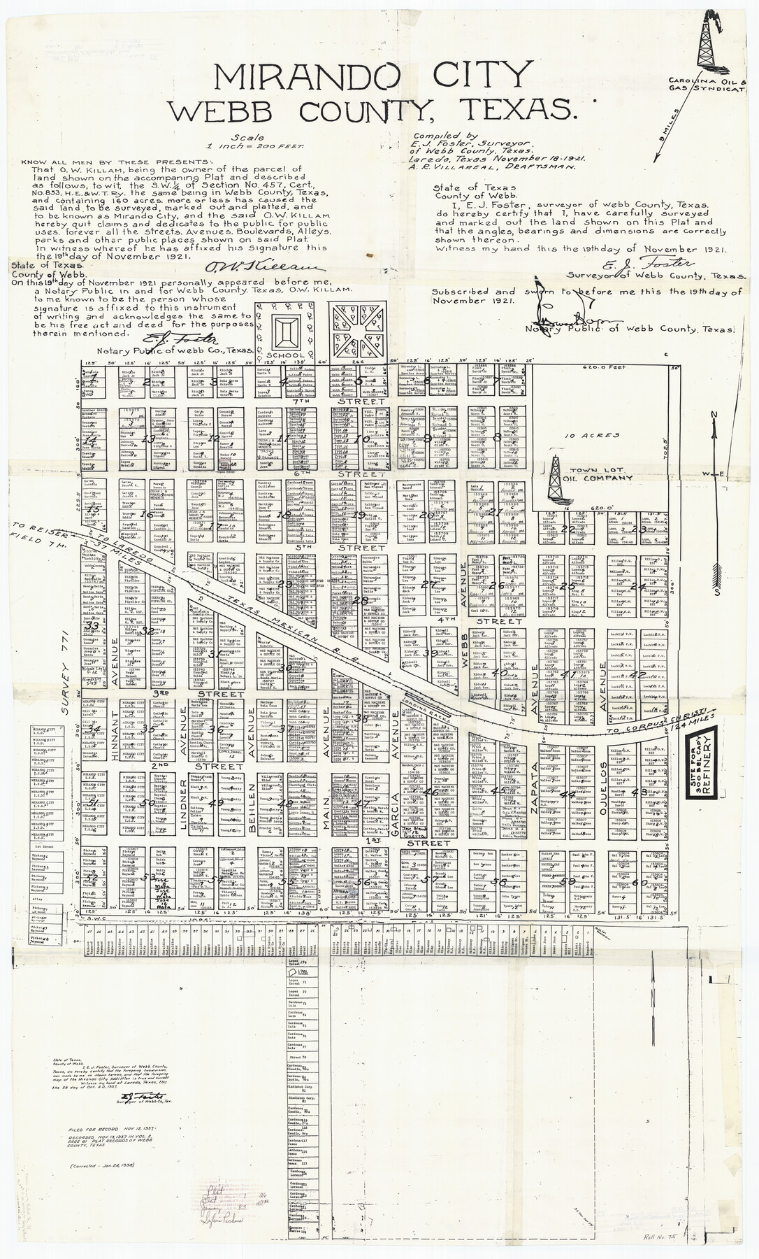
Mirando City, Webb County, Texas
[Formerly] Webb County Rolled Sketch 75
A-6-72; Webb County Rolled Sketch 75
-
Map/Doc
10132
-
Collection
General Map Collection
-
Object Dates
1937/10/28 (Creation Date)
1983/3/1 (File Date)
-
People and Organizations
E.J. Foster (Compiler)
E.J. Foster (Surveyor/Engineer)
-
Counties
Webb
-
Subjects
City
-
Height x Width
60.0 x 36.2 inches
152.4 x 91.9 cm
-
Comments
Certified copy of Mirando City.
Formerly Webb County Rolled Sketch 75
Part of: General Map Collection
Val Verde County Sketch File 46

Print $20.00
- Digital $50.00
Val Verde County Sketch File 46
1951
Size 18.9 x 22.6 inches
Map/Doc 12587
University Lands Situated in Robertson County

Print $20.00
- Digital $50.00
University Lands Situated in Robertson County
1841
Size 22.8 x 26.2 inches
Map/Doc 281
Ward County Working Sketch Graphic Index - sheet A

Print $40.00
- Digital $50.00
Ward County Working Sketch Graphic Index - sheet A
1932
Size 30.8 x 52.8 inches
Map/Doc 76731
Hudspeth County Working Sketch 13

Print $40.00
- Digital $50.00
Hudspeth County Working Sketch 13
1952
Size 34.3 x 51.4 inches
Map/Doc 66295
Uvalde County Rolled Sketch 9

Print $20.00
- Digital $50.00
Uvalde County Rolled Sketch 9
1924
Size 16.6 x 24.6 inches
Map/Doc 8094
Schleicher County Sketch File 26

Print $6.00
- Digital $50.00
Schleicher County Sketch File 26
1938
Size 9.3 x 14.5 inches
Map/Doc 36524
Kerr County Working Sketch 36

Print $20.00
- Digital $50.00
Kerr County Working Sketch 36
1991
Size 32.8 x 35.8 inches
Map/Doc 70067
Aransas Pass to Baffin Bay

Print $20.00
- Digital $50.00
Aransas Pass to Baffin Bay
1966
Size 42.3 x 34.9 inches
Map/Doc 73416
Maps & Lists Showing Prison Lands (Oil & Gas) Leased as of June 1955

Digital $50.00
Maps & Lists Showing Prison Lands (Oil & Gas) Leased as of June 1955
1934
Size 29.6 x 38.1 inches
Map/Doc 62880
Robertson Co.

Print $40.00
- Digital $50.00
Robertson Co.
1945
Size 49.5 x 40.3 inches
Map/Doc 95627
Texas 1972 Official Highway Travel Map

Digital $50.00
Texas 1972 Official Highway Travel Map
Size 28.2 x 36.4 inches
Map/Doc 94314
Clay County Sketch File 27

Print $20.00
- Digital $50.00
Clay County Sketch File 27
1900
Size 18.8 x 16.5 inches
Map/Doc 11089
You may also like
Rockwall County Boundary File 1

Print $10.00
- Digital $50.00
Rockwall County Boundary File 1
Size 13.3 x 8.3 inches
Map/Doc 58380
Gaines County Working Sketch 32

Print $20.00
- Digital $50.00
Gaines County Working Sketch 32
1990
Size 38.3 x 26.3 inches
Map/Doc 69332
Waller County Working Sketch 5

Print $20.00
- Digital $50.00
Waller County Working Sketch 5
1966
Size 23.1 x 27.1 inches
Map/Doc 72304
Highway Map of the State of Texas

Print $20.00
Highway Map of the State of Texas
1922
Size 34.0 x 36.5 inches
Map/Doc 79309
Harris County Working Sketch 71

Print $20.00
- Digital $50.00
Harris County Working Sketch 71
1957
Size 26.8 x 42.3 inches
Map/Doc 65963
Erath County Working Sketch 44

Print $20.00
- Digital $50.00
Erath County Working Sketch 44
1981
Size 29.7 x 30.4 inches
Map/Doc 69125
Upshur County Rolled Sketch 1

Print $40.00
- Digital $50.00
Upshur County Rolled Sketch 1
1953
Size 50.2 x 44.7 inches
Map/Doc 10298
Culberson County Sketch File WJ

Print $8.00
- Digital $50.00
Culberson County Sketch File WJ
Size 14.2 x 28.2 inches
Map/Doc 5786
Kimble County Working Sketch 63

Print $20.00
- Digital $50.00
Kimble County Working Sketch 63
1964
Size 31.2 x 34.2 inches
Map/Doc 70131
Kenedy County Boundary File 2

Print $22.00
- Digital $50.00
Kenedy County Boundary File 2
Size 11.2 x 8.6 inches
Map/Doc 55782
Fort Bend County Rolled Sketch 10

Print $99.00
- Digital $50.00
Fort Bend County Rolled Sketch 10
1958
Size 9.9 x 15.9 inches
Map/Doc 44707
Loving County Sketch File 5

Print $10.00
- Digital $50.00
Loving County Sketch File 5
Size 9.7 x 8.3 inches
Map/Doc 30412