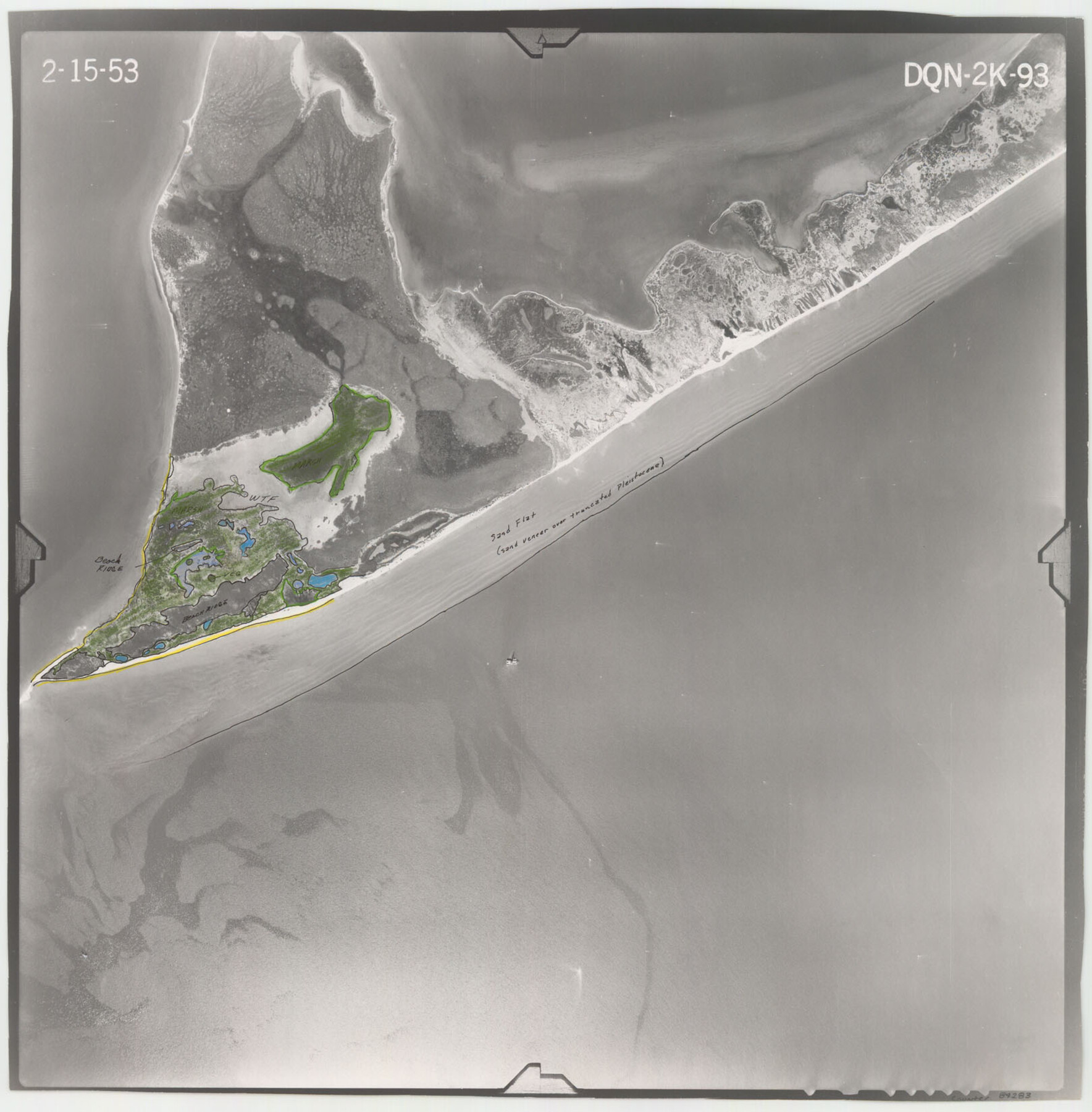
Flight Mission No. DQN-2K, Frame 93, Calhoun County
DQN-2K-93
-
Map/Doc
84283
-
Collection
General Map Collection
-
Object Dates
1953/2/15 (Creation Date)
-
People and Organizations
U. S. Department of Agriculture (Publisher)
-
Counties
Calhoun
-
Subjects
Aerial Photograph
-
Height x Width
16.5 x 16.2 inches
41.9 x 41.1 cm
-
Comments
Flown by Aero Exploration Company of Tulsa, Oklahoma.
Part of: General Map Collection
Part of Laguna Madre in Cameron County, showing Subdivision for Mineral Development

Print $20.00
- Digital $50.00
Part of Laguna Madre in Cameron County, showing Subdivision for Mineral Development
1963
Size 45.8 x 36.0 inches
Map/Doc 1926
Galveston County Working Sketch 7

Print $20.00
- Digital $50.00
Galveston County Working Sketch 7
1936
Size 18.0 x 20.6 inches
Map/Doc 69344
Right of Way & Track Map San Antonio & Aransas Pass Railway Co.

Print $40.00
- Digital $50.00
Right of Way & Track Map San Antonio & Aransas Pass Railway Co.
1919
Size 25.8 x 57.1 inches
Map/Doc 64027
Borden County Sketch File 6

Print $8.00
- Digital $50.00
Borden County Sketch File 6
1900
Size 11.2 x 8.7 inches
Map/Doc 14719
Brewster County Rolled Sketch 114

Print $20.00
- Digital $50.00
Brewster County Rolled Sketch 114
1964
Size 11.8 x 17.8 inches
Map/Doc 5289
General-karte der Vereinigten Staaten von Nord-Amerika nebst den grosst. Theilen von Canada & Tejas

Print $20.00
- Digital $50.00
General-karte der Vereinigten Staaten von Nord-Amerika nebst den grosst. Theilen von Canada & Tejas
Size 30.3 x 38.9 inches
Map/Doc 96790
Dickens County Sketch File 18aa

Print $20.00
- Digital $50.00
Dickens County Sketch File 18aa
Size 17.2 x 18.2 inches
Map/Doc 11323
Newton County Working Sketch 39

Print $20.00
- Digital $50.00
Newton County Working Sketch 39
1961
Size 36.6 x 41.0 inches
Map/Doc 71285
Ochiltree County Working Sketch 1

Print $20.00
- Digital $50.00
Ochiltree County Working Sketch 1
1954
Size 16.7 x 11.6 inches
Map/Doc 71314

Angelina County Working Sketch 35

Print $20.00
- Digital $50.00
Angelina County Working Sketch 35
1957
Size 27.4 x 29.6 inches
Map/Doc 67118
Nueces County Rolled Sketch 74

Print $32.00
Nueces County Rolled Sketch 74
1981
Size 18.4 x 25.3 inches
Map/Doc 6932
You may also like
Central Lea County, New Mexico

Print $40.00
- Digital $50.00
Central Lea County, New Mexico
Size 40.6 x 60.2 inches
Map/Doc 89909
Nolan County Sketch File 8

Print $2.00
- Digital $50.00
Nolan County Sketch File 8
Size 11.3 x 8.8 inches
Map/Doc 32464
La Salle County Working Sketch 4

Print $20.00
- Digital $50.00
La Salle County Working Sketch 4
1915
Size 31.6 x 36.6 inches
Map/Doc 70305
Brazoria County Rolled Sketch 41

Print $20.00
- Digital $50.00
Brazoria County Rolled Sketch 41
Size 30.3 x 21.3 inches
Map/Doc 5176
Jeff Davis County Rolled Sketch 10

Print $6.00
- Digital $50.00
Jeff Davis County Rolled Sketch 10
1906
Size 29.6 x 30.1 inches
Map/Doc 6363
General Highway Map, Rains County, Texas

Print $20.00
General Highway Map, Rains County, Texas
1961
Size 18.1 x 24.4 inches
Map/Doc 79634
[Large surveys along the Navasota River]
![48, [Large surveys along the Navasota River], General Map Collection](https://historictexasmaps.com/wmedia_w700/maps/48.tif.jpg)
Print $20.00
- Digital $50.00
[Large surveys along the Navasota River]
1840
Size 24.5 x 14.3 inches
Map/Doc 48
Marion County Sketch File 18

Print $77.00
- Digital $50.00
Marion County Sketch File 18
1913
Size 10.3 x 12.3 inches
Map/Doc 30590
Palo Pinto County Sketch File 29

Print $40.00
- Digital $50.00
Palo Pinto County Sketch File 29
1874
Size 12.8 x 16.0 inches
Map/Doc 33419
Flight Mission No. BRA-7M, Frame 183, Jefferson County

Print $20.00
- Digital $50.00
Flight Mission No. BRA-7M, Frame 183, Jefferson County
1953
Size 18.6 x 22.3 inches
Map/Doc 85551
Map of Brazoria County

Print $20.00
- Digital $50.00
Map of Brazoria County
1918
Size 26.1 x 22.6 inches
Map/Doc 1518
Montague County Working Sketch 31

Print $20.00
- Digital $50.00
Montague County Working Sketch 31
1975
Size 25.5 x 25.8 inches
Map/Doc 71097