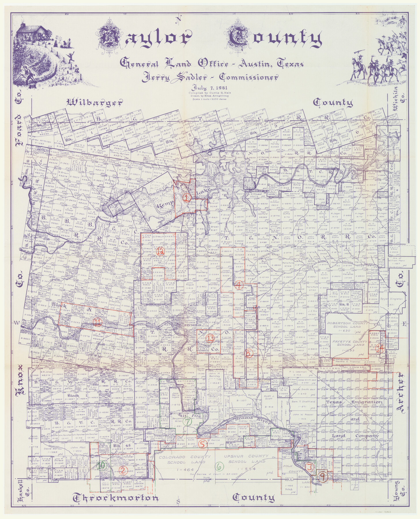
Baylor County Working Sketch Graphic Index
-
Map/Doc
76463
-
Collection
General Map Collection
-
Object Dates
7/7/1961 (Creation Date)
-
People and Organizations
Curtis R. Hale (Compiler)
Eltea Armstrong (Draftsman)
-
Counties
Baylor
-
Subjects
County Surveying Working Sketch
-
Height x Width
41.1 x 33.6 inches
104.4 x 85.3 cm
-
Scale
1" = 2000 varas
Part of: General Map Collection
Dimmit County Sketch File 9a

Print $4.00
- Digital $50.00
Dimmit County Sketch File 9a
Size 12.7 x 8.2 inches
Map/Doc 21073
Reeves County Working Sketch 64

Print $20.00
- Digital $50.00
Reeves County Working Sketch 64
1984
Size 26.3 x 26.5 inches
Map/Doc 63507
Matagorda County Boundary File 1b

Print $6.00
- Digital $50.00
Matagorda County Boundary File 1b
Size 14.2 x 8.5 inches
Map/Doc 56893
Tarrant County Sketch File 33

Print $48.00
- Digital $50.00
Tarrant County Sketch File 33
1954
Size 11.6 x 8.8 inches
Map/Doc 37759
Gaines County Rolled Sketch 9

Print $20.00
- Digital $50.00
Gaines County Rolled Sketch 9
Size 20.9 x 29.8 inches
Map/Doc 5929
FT. W. & R. G. Ry. Right of Way Map, Winchell to Brady, McCulloch County, Texas

Print $20.00
- Digital $50.00
FT. W. & R. G. Ry. Right of Way Map, Winchell to Brady, McCulloch County, Texas
1918
Size 36.9 x 32.0 inches
Map/Doc 61416
[Galveston, Harrisburg & San Antonio Railroad from Cuero to Stockdale]
![64190, [Galveston, Harrisburg & San Antonio Railroad from Cuero to Stockdale], General Map Collection](https://historictexasmaps.com/wmedia_w700/maps/64190.tif.jpg)
Print $20.00
- Digital $50.00
[Galveston, Harrisburg & San Antonio Railroad from Cuero to Stockdale]
1907
Size 13.7 x 34.0 inches
Map/Doc 64190
Flight Mission No. BRE-4P, Frame 171, Nueces County

Print $20.00
- Digital $50.00
Flight Mission No. BRE-4P, Frame 171, Nueces County
1956
Size 18.6 x 22.5 inches
Map/Doc 86834
Milam County Boundary File 4

Print $4.00
- Digital $50.00
Milam County Boundary File 4
Size 13.3 x 8.2 inches
Map/Doc 57221
Clay County Sketch File 20

Print $8.00
- Digital $50.00
Clay County Sketch File 20
1882
Size 11.2 x 8.6 inches
Map/Doc 18431
Map of Abilene

Print $20.00
- Digital $50.00
Map of Abilene
1885
Size 24.6 x 27.4 inches
Map/Doc 3042
Lampasas County Working Sketch 4

Print $20.00
- Digital $50.00
Lampasas County Working Sketch 4
1941
Size 23.1 x 16.8 inches
Map/Doc 70281
You may also like
Shelby County Sketch File 21

Print $2.00
- Digital $50.00
Shelby County Sketch File 21
Size 8.9 x 4.0 inches
Map/Doc 36642
[Map of Portion of Pecos County as Surveyed by F. F. Friend]
![91562, [Map of Portion of Pecos County as Surveyed by F. F. Friend], Twichell Survey Records](https://historictexasmaps.com/wmedia_w700/maps/91562-1.tif.jpg)
Print $3.00
- Digital $50.00
[Map of Portion of Pecos County as Surveyed by F. F. Friend]
1926
Size 17.0 x 11.4 inches
Map/Doc 91562
Map of the Country Upon the Brazos and Big Wichita Rivers Embracing the Lands appropriated by the State of Texas for the Use of the Indians

Print $20.00
Map of the Country Upon the Brazos and Big Wichita Rivers Embracing the Lands appropriated by the State of Texas for the Use of the Indians
1854
Size 28.8 x 32.3 inches
Map/Doc 76284
[Portion of Harris County]
![78481, [Portion of Harris County], General Map Collection](https://historictexasmaps.com/wmedia_w700/maps/78481.tif.jpg)
Print $2.00
- Digital $50.00
[Portion of Harris County]
Size 7.9 x 5.1 inches
Map/Doc 78481
[Surveys in the Bexar District along the Atascosa Creek]
![221, [Surveys in the Bexar District along the Atascosa Creek], General Map Collection](https://historictexasmaps.com/wmedia_w700/maps/221.tif.jpg)
Print $2.00
- Digital $50.00
[Surveys in the Bexar District along the Atascosa Creek]
1842
Size 5.9 x 5.9 inches
Map/Doc 221
Your Opportunity - the Magic Valley - Money Will Grow on Trees! Learn Where How and Why!

Your Opportunity - the Magic Valley - Money Will Grow on Trees! Learn Where How and Why!
1928
Map/Doc 96740
[Maps of surveys in Reeves & Culberson Cos]
![61147, [Maps of surveys in Reeves & Culberson Cos], General Map Collection](https://historictexasmaps.com/wmedia_w700/maps/61147.tif.jpg)
Print $20.00
- Digital $50.00
[Maps of surveys in Reeves & Culberson Cos]
1937
Size 30.6 x 24.9 inches
Map/Doc 61147
Bosque County Sketch File 23

Print $6.00
- Digital $50.00
Bosque County Sketch File 23
1863
Size 10.2 x 8.2 inches
Map/Doc 14806
Culberson County Working Sketch 45

Print $20.00
- Digital $50.00
Culberson County Working Sketch 45
1971
Size 24.4 x 37.1 inches
Map/Doc 68499
Jim Hogg County Rolled Sketch 9

Print $20.00
- Digital $50.00
Jim Hogg County Rolled Sketch 9
1974
Size 18.2 x 19.8 inches
Map/Doc 6443

Hudspeth County Working Sketch 47

Print $20.00
- Digital $50.00
Hudspeth County Working Sketch 47
1984
Size 27.3 x 38.6 inches
Map/Doc 78211