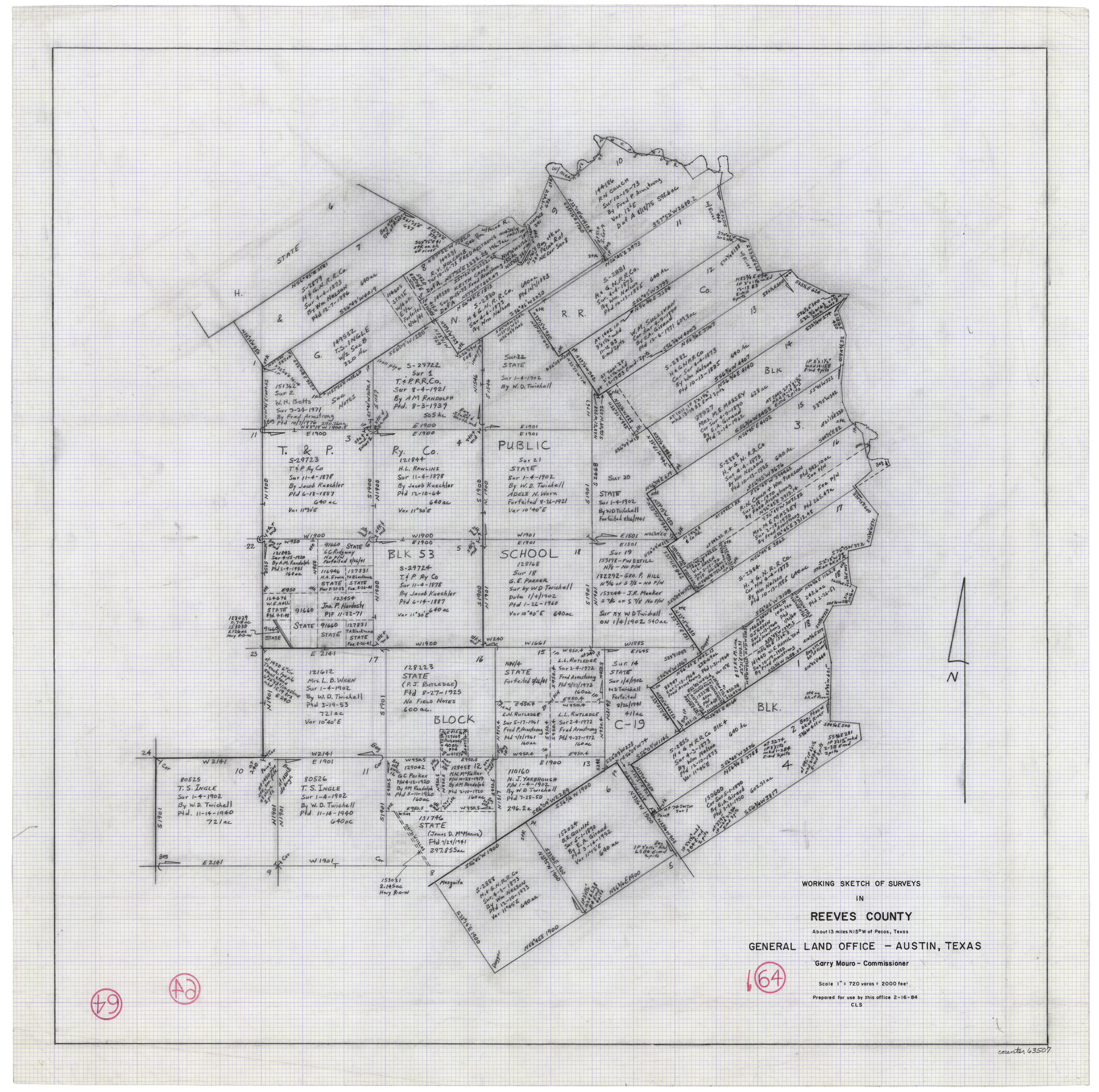
Reeves County Working Sketch 64
-
Map/Doc
63507
-
Collection
General Map Collection
-
Object Dates
2/16/1984 (Creation Date)
-
People and Organizations
Crockett L. Slover (Draftsman)
-
Counties
Reeves
-
Subjects
Surveying Working Sketch
-
Height x Width
26.3 x 26.5 inches
66.8 x 67.3 cm
-
Scale
1" = 720 varas
Part of: General Map Collection
Anderson County Working Sketch 40

Print $20.00
- Digital $50.00
Anderson County Working Sketch 40
1986
Size 17.0 x 20.3 inches
Map/Doc 67040
Howard County Boundary File 4b

Print $24.00
- Digital $50.00
Howard County Boundary File 4b
Size 11.3 x 8.9 inches
Map/Doc 55168
Cass County Working Sketch 35

Print $20.00
- Digital $50.00
Cass County Working Sketch 35
1982
Size 23.5 x 44.8 inches
Map/Doc 67938
Edwards County Working Sketch 6

Print $40.00
- Digital $50.00
Edwards County Working Sketch 6
1918
Size 32.8 x 79.6 inches
Map/Doc 68882
Hill County Sketch File 1

Print $4.00
- Digital $50.00
Hill County Sketch File 1
1857
Size 9.0 x 7.9 inches
Map/Doc 26459
Potter County Sketch File 20

Print $4.00
- Digital $50.00
Potter County Sketch File 20
Size 12.2 x 8.7 inches
Map/Doc 34411
Flight Mission No. BRA-8M, Frame 132, Jefferson County

Print $20.00
- Digital $50.00
Flight Mission No. BRA-8M, Frame 132, Jefferson County
1953
Size 18.7 x 22.3 inches
Map/Doc 85628
Map of Liberty County

Print $40.00
- Digital $50.00
Map of Liberty County
1841
Size 60.1 x 37.3 inches
Map/Doc 1951
Eastland County

Print $20.00
- Digital $50.00
Eastland County
1879
Size 21.3 x 21.3 inches
Map/Doc 3499
Coast Chart No. 212 - From Latitude 26° 33' to the Rio Grande, Texas

Print $20.00
- Digital $50.00
Coast Chart No. 212 - From Latitude 26° 33' to the Rio Grande, Texas
1886
Size 37.8 x 34.1 inches
Map/Doc 73503
Culberson County Rolled Sketch 38A
Print $20.00
- Digital $50.00
Culberson County Rolled Sketch 38A
Size 27.2 x 30.0 inches
Map/Doc 5662
Brewster County Rolled Sketch 114

Print $20.00
- Digital $50.00
Brewster County Rolled Sketch 114
1964
Size 11.5 x 17.6 inches
Map/Doc 5274
You may also like
Rains County Sketch File 9

Print $20.00
- Digital $50.00
Rains County Sketch File 9
Size 14.2 x 16.3 inches
Map/Doc 34960
Clay County Sketch File 11a

Print $22.00
- Digital $50.00
Clay County Sketch File 11a
1861
Size 18.3 x 11.9 inches
Map/Doc 11084
Lamb County Sketch File 15

Print $6.00
- Digital $50.00
Lamb County Sketch File 15
Size 9.8 x 10.9 inches
Map/Doc 29377
Flight Mission No. DIX-5P, Frame 111, Aransas County

Print $20.00
- Digital $50.00
Flight Mission No. DIX-5P, Frame 111, Aransas County
1956
Size 17.6 x 18.0 inches
Map/Doc 83790
Austin County Sketch File 12

Print $40.00
- Digital $50.00
Austin County Sketch File 12
Size 22.5 x 18.0 inches
Map/Doc 10876
Flight Mission No. CRK-7P, Frame 133, Refugio County

Print $20.00
- Digital $50.00
Flight Mission No. CRK-7P, Frame 133, Refugio County
1956
Size 18.3 x 22.1 inches
Map/Doc 86956
Jeff Davis County Sketch File 11

Print $20.00
- Digital $50.00
Jeff Davis County Sketch File 11
Size 17.7 x 29.9 inches
Map/Doc 11858
Coke County Rolled Sketch 9

Print $20.00
- Digital $50.00
Coke County Rolled Sketch 9
Size 25.7 x 20.7 inches
Map/Doc 5508
Map of Ellis County

Print $20.00
- Digital $50.00
Map of Ellis County
1857
Size 20.2 x 28.1 inches
Map/Doc 3510
America Septentrionalis

Print $20.00
- Digital $50.00
America Septentrionalis
1646
Size 20.0 x 23.4 inches
Map/Doc 93817
Liberty County Working Sketch Graphic Index - west part

Print $20.00
- Digital $50.00
Liberty County Working Sketch Graphic Index - west part
1977
Size 45.7 x 34.5 inches
Map/Doc 76619
Maps of Gulf Intracoastal Waterway, Texas - Sabine River to the Rio Grande and connecting waterways including ship channels

Print $20.00
- Digital $50.00
Maps of Gulf Intracoastal Waterway, Texas - Sabine River to the Rio Grande and connecting waterways including ship channels
1966
Size 14.6 x 22.2 inches
Map/Doc 61967