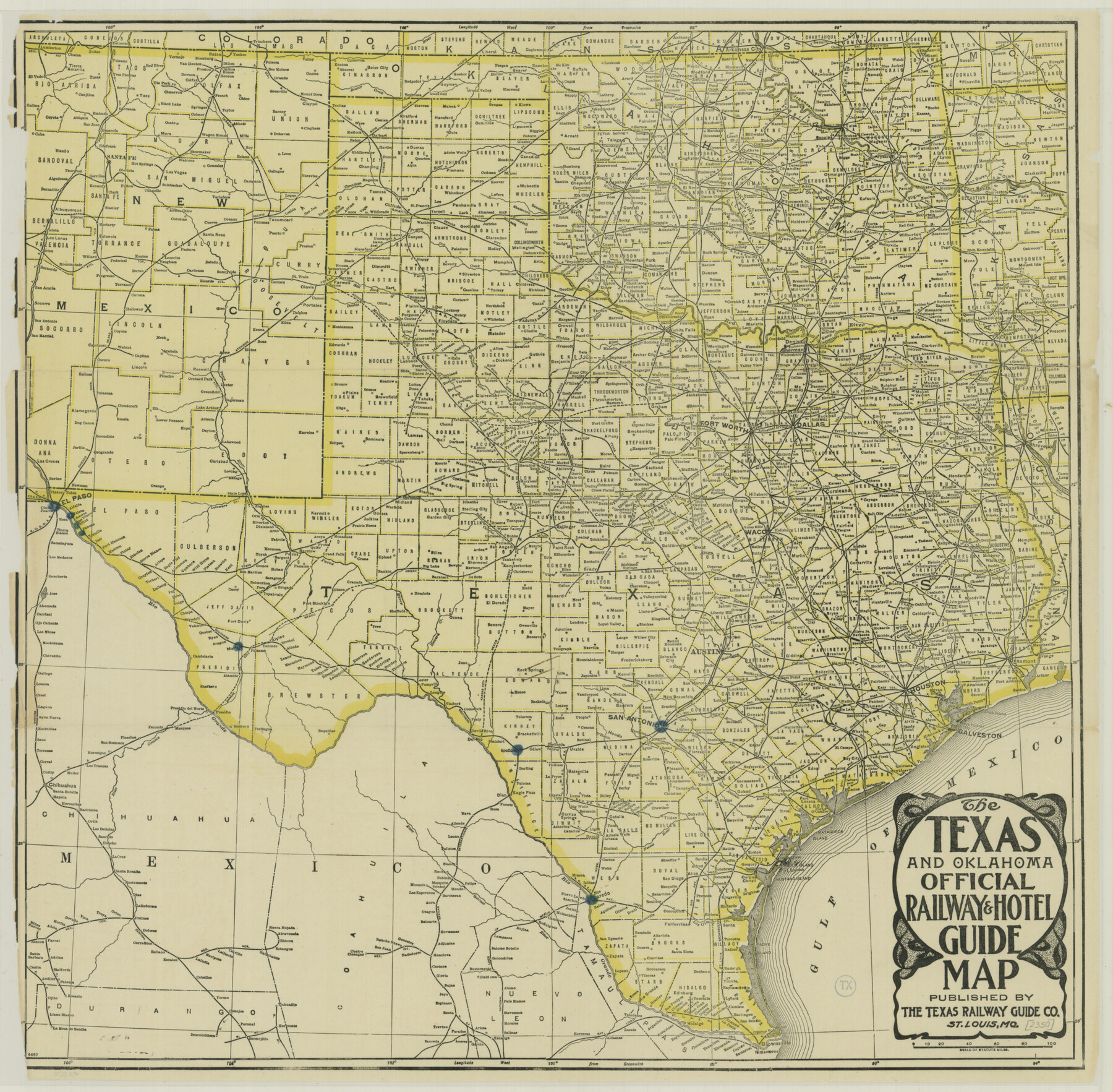
The Texas and Oklahoma Official Railway and Hotel Guide Map
-
Map/Doc
76276
-
Collection
Texas State Library and Archives
-
Object Dates
[1912] (Creation Date)
-
People and Organizations
Texas Railway Guide Company (Publisher)
-
Subjects
Railroads State of Texas
-
Height x Width
23.4 x 23.9 inches
59.4 x 60.7 cm
-
Comments
Prints available courtesy of the Texas State Library and Archives.
More info can be found here: TSLAC Map 02350
Related maps
The Texas & Oklahoma Official Railway & Hotel Guide Map

Print $20.00
- Digital $50.00
The Texas & Oklahoma Official Railway & Hotel Guide Map
1917
Size 23.6 x 24.1 inches
Map/Doc 94032
The Texas and Oklahoma Official Railway & Hotel Guide Map

Print $20.00
- Digital $50.00
The Texas and Oklahoma Official Railway & Hotel Guide Map
1918
Size 23.4 x 24.0 inches
Map/Doc 95893
Part of: Texas State Library and Archives
Plan of the City of Austin

Print $20.00
Plan of the City of Austin
1839
Size 24.2 x 19.4 inches
Map/Doc 76204
General Highway Map, El Paso County, Texas

Print $20.00
General Highway Map, El Paso County, Texas
1961
Size 18.4 x 24.6 inches
Map/Doc 79455
General Highway Map, Callahan County, Texas

Print $20.00
General Highway Map, Callahan County, Texas
1940
Size 25.3 x 18.4 inches
Map/Doc 79037
Map of Texas compiled from surveys at the Land Office of Texas

Print $20.00
Map of Texas compiled from surveys at the Land Office of Texas
1851
Size 27.2 x 19.5 inches
Map/Doc 79748
General Highway Map, Aransas County, Texas

Print $20.00
General Highway Map, Aransas County, Texas
1961
Size 18.3 x 25.0 inches
Map/Doc 79352
General Highway Map, Burleson County, Texas

Print $20.00
General Highway Map, Burleson County, Texas
1940
Size 18.3 x 25.0 inches
Map/Doc 79032
General Highway Map, Andrews County, Gaines County, Texas

Print $20.00
General Highway Map, Andrews County, Gaines County, Texas
1940
Size 24.9 x 18.4 inches
Map/Doc 79002
General Highway Map, Jasper County, Newton County, Texas

Print $20.00
General Highway Map, Jasper County, Newton County, Texas
1940
Size 18.6 x 25.2 inches
Map/Doc 79142
General Highway Map, Henderson County, Texas

Print $20.00
General Highway Map, Henderson County, Texas
1961
Size 24.9 x 18.0 inches
Map/Doc 79517
General Highway Map, Caldwell County, Texas

Print $20.00
General Highway Map, Caldwell County, Texas
1940
Size 18.5 x 25.2 inches
Map/Doc 79034
General Highway Map, Moore County, Texas

Print $20.00
General Highway Map, Moore County, Texas
1961
Size 18.1 x 24.5 inches
Map/Doc 79604
Mitchell's Travellers Guide Through the United States. A Map of the Roads, Distances, Steam Boat, and Canal Routes etc.

Print $20.00
Mitchell's Travellers Guide Through the United States. A Map of the Roads, Distances, Steam Boat, and Canal Routes etc.
1835
Size 18.0 x 22.7 inches
Map/Doc 79723
You may also like
Angelina County Sketch File 11c

Print $7.00
- Digital $50.00
Angelina County Sketch File 11c
Size 11.1 x 6.0 inches
Map/Doc 12946
Map of Orange County

Print $20.00
- Digital $50.00
Map of Orange County
1862
Size 13.6 x 16.5 inches
Map/Doc 3929
Map of East Texas Oil Field

Print $20.00
- Digital $50.00
Map of East Texas Oil Field
1933
Size 16.5 x 17.8 inches
Map/Doc 93949
Bastrop County Working Sketch 13

Print $20.00
- Digital $50.00
Bastrop County Working Sketch 13
1979
Size 23.6 x 30.0 inches
Map/Doc 67313
Brooks County Rolled Sketch 20

Print $20.00
- Digital $50.00
Brooks County Rolled Sketch 20
1943
Size 27.0 x 26.4 inches
Map/Doc 5342
Garza County Working Sketch 13

Print $20.00
- Digital $50.00
Garza County Working Sketch 13
1956
Size 19.0 x 12.7 inches
Map/Doc 63160
Map of the Missouri, Kansas & Texas Railway and its connecting lines

Print $20.00
- Digital $50.00
Map of the Missouri, Kansas & Texas Railway and its connecting lines
1901
Size 16.3 x 9.1 inches
Map/Doc 95810
Navigation Maps of Gulf Intracoastal Waterway, Port Arthur to Brownsville, Texas

Print $4.00
- Digital $50.00
Navigation Maps of Gulf Intracoastal Waterway, Port Arthur to Brownsville, Texas
1951
Size 16.6 x 21.5 inches
Map/Doc 65430
No. 2 Chart of Corpus Christi Pass, Texas

Print $20.00
- Digital $50.00
No. 2 Chart of Corpus Christi Pass, Texas
1878
Size 18.3 x 27.4 inches
Map/Doc 73015
Bee County Sketch File 33

Print $56.00
- Digital $50.00
Bee County Sketch File 33
Size 11.3 x 8.9 inches
Map/Doc 14349
[Subdivision Plat of 80 acres]
![93074, [Subdivision Plat of 80 acres], Twichell Survey Records](https://historictexasmaps.com/wmedia_w700/maps/93074-1.tif.jpg)
Print $2.00
- Digital $50.00
[Subdivision Plat of 80 acres]
Size 10.6 x 6.3 inches
Map/Doc 93074
Flight Mission No. BQY-14M, Frame 181, Harris County

Print $20.00
- Digital $50.00
Flight Mission No. BQY-14M, Frame 181, Harris County
1953
Size 18.7 x 22.2 inches
Map/Doc 85297