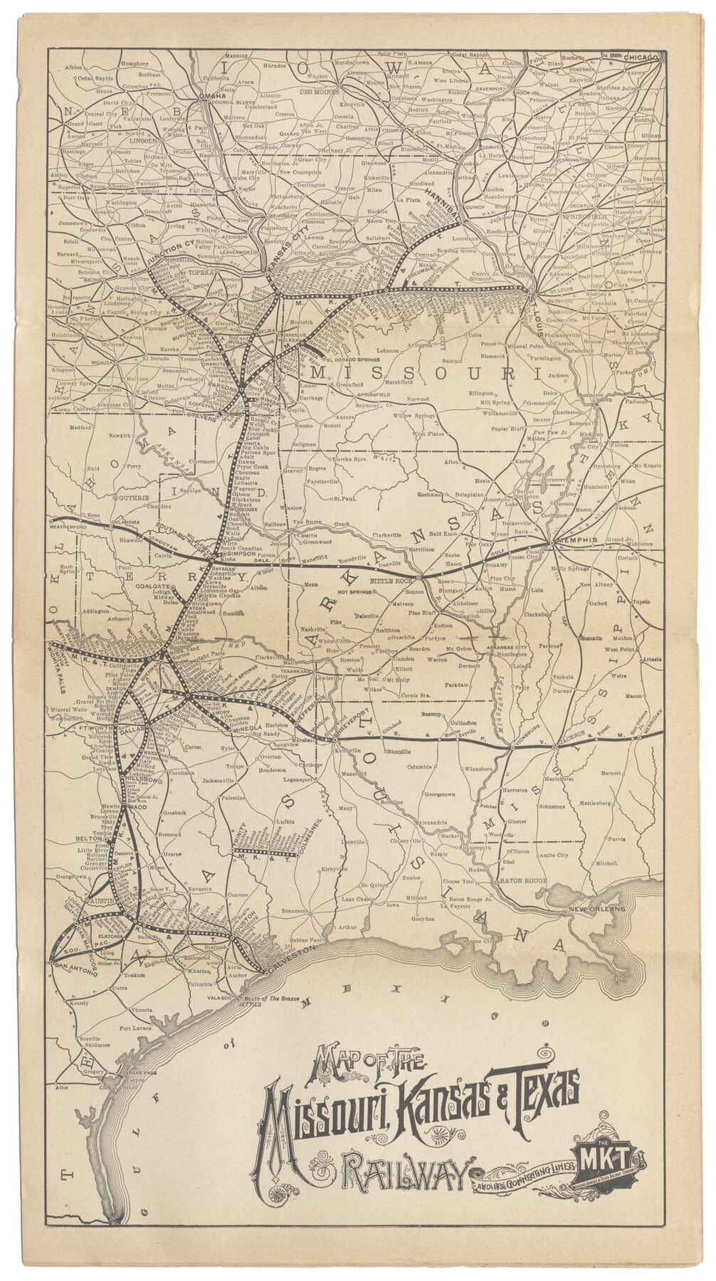
Map of the Missouri, Kansas & Texas Railway and its connecting lines
The "Katy Flyer", the M. K. and T., Missouri, Kansas & Texas Railway, Missouri, Kansas, Indian Territory, Texas
-
Map/Doc
95810
-
Collection
Cobb Digital Map Collection
-
Object Dates
1901 (Creation Date)
-
Subjects
Railroads
-
Height x Width
16.3 x 9.1 inches
41.4 x 23.1 cm
-
Medium
digital image
-
Comments
Courtesy of John & Diana Cobb.
To view full booklet in which this map was contained, click "Download PDF" link above.
Part of: Cobb Digital Map Collection

The Beautiful Valley of the Lower Rio Grande

The Beautiful Valley of the Lower Rio Grande
1925
Map/Doc 96735

Rand, McNally & Co.'s Texas

Print $20.00
- Digital $50.00
Rand, McNally & Co.'s Texas
1893
Size 21.3 x 28.3 inches
Map/Doc 95842
[Map of Texas showing Frisco Lines]
![95796, [Map of Texas showing Frisco Lines], Cobb Digital Map Collection](https://historictexasmaps.com/wmedia_w700/maps/95796.tif.jpg)
Print $20.00
- Digital $50.00
[Map of Texas showing Frisco Lines]
1910
Size 19.8 x 19.2 inches
Map/Doc 95796

The Great Texas Route via the Beautiful Indian Territory / The Great Kansas Route via the Picturesque Valley of the Neosho

Print $20.00
- Digital $50.00
The Great Texas Route via the Beautiful Indian Territory / The Great Kansas Route via the Picturesque Valley of the Neosho
1876
Size 12.1 x 17.4 inches
Map/Doc 95804
Map of the Southern Pacific Company and connections

Print $20.00
- Digital $50.00
Map of the Southern Pacific Company and connections
1890
Size 9.6 x 23.8 inches
Map/Doc 95759
The Texas and Oklahoma Official Railway & Hotel Guide Map

Print $20.00
- Digital $50.00
The Texas and Oklahoma Official Railway & Hotel Guide Map
1918
Size 23.4 x 24.0 inches
Map/Doc 95893
MKT - Missouri, Kansas, Texas Lines

Print $20.00
- Digital $50.00
MKT - Missouri, Kansas, Texas Lines
1930
Size 9.1 x 16.1 inches
Map/Doc 95811

The Texas Coast Country and What It Holds for You

The Texas Coast Country and What It Holds for You
1909
Size 6.4 x 3.7 inches
Map/Doc 97054
You may also like
[Blocks M1 and 3T]
![91515, [Blocks M1 and 3T], Twichell Survey Records](https://historictexasmaps.com/wmedia_w700/maps/91515-1.tif.jpg)
Print $20.00
- Digital $50.00
[Blocks M1 and 3T]
Size 10.1 x 26.3 inches
Map/Doc 91515
The Republic County of Robertson. December 29, 1845

Print $20.00
The Republic County of Robertson. December 29, 1845
2020
Size 16.9 x 21.7 inches
Map/Doc 96264
Travis County Working Sketch 49

Print $20.00
- Digital $50.00
Travis County Working Sketch 49
1984
Size 33.9 x 37.2 inches
Map/Doc 69433
United States Gulf Coast - from Galveston to the Rio Grande

Print $20.00
- Digital $50.00
United States Gulf Coast - from Galveston to the Rio Grande
1915
Size 26.9 x 18.3 inches
Map/Doc 72732
Culberson County Working Sketch 87

Print $20.00
- Digital $50.00
Culberson County Working Sketch 87
1981
Size 26.9 x 37.1 inches
Map/Doc 68541
Andrews County Rolled Sketch 28

Print $20.00
- Digital $50.00
Andrews County Rolled Sketch 28
1948
Size 17.0 x 25.5 inches
Map/Doc 77172
Val Verde County Working Sketch 83

Print $40.00
- Digital $50.00
Val Verde County Working Sketch 83
1973
Size 28.7 x 53.6 inches
Map/Doc 72218
Laguna Madre, Register No. 1476B

Print $40.00
- Digital $50.00
Laguna Madre, Register No. 1476B
1880
Size 33.7 x 56.2 inches
Map/Doc 73605
Newton County Rolled Sketch 21

Print $40.00
- Digital $50.00
Newton County Rolled Sketch 21
1957
Size 29.9 x 52.5 inches
Map/Doc 9582
Hill County Sketch File 22

Print $8.00
- Digital $50.00
Hill County Sketch File 22
1860
Size 7.7 x 8.2 inches
Map/Doc 26505
Flight Mission No. DQN-2K, Frame 144, Calhoun County

Print $20.00
- Digital $50.00
Flight Mission No. DQN-2K, Frame 144, Calhoun County
1953
Size 18.7 x 22.4 inches
Map/Doc 84313
Terrell County Rolled Sketch 28

Print $40.00
- Digital $50.00
Terrell County Rolled Sketch 28
1929
Size 28.0 x 67.7 inches
Map/Doc 7935