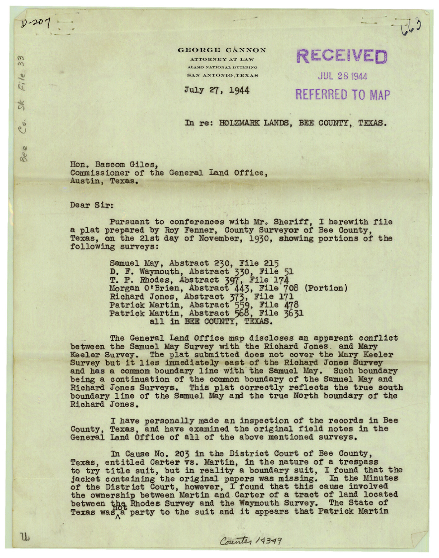
Bee County Sketch File 33
[Correspondence, field notes and plat of Holzmark lands to show the relation of the Samuel May, D.F. Waymouth, R. Jones, & T.P. Rhodes surveys]
-
Map/Doc
14349
-
Collection
General Map Collection
-
Object Dates
1930 (Survey Date)
1944/7/28 (File Date)
1944/7/27 (Correspondence Date)
-
People and Organizations
George Cannon (Attorney)
Roy Fenner (Surveyor/Engineer)
H.N. Whalen (Chainman/Field Personnel)
Albert McCoy (Chainman/Field Personnel)
-
Counties
Bee
-
Subjects
Surveying Sketch File
-
Height x Width
11.3 x 8.9 inches
28.7 x 22.6 cm
-
Medium
multi-page, multi-format
Part of: General Map Collection
Flight Mission No. BRA-16M, Frame 62, Jefferson County

Print $20.00
- Digital $50.00
Flight Mission No. BRA-16M, Frame 62, Jefferson County
1953
Size 18.7 x 22.4 inches
Map/Doc 85679
Map of a part of the North Portion of Harris County

Print $40.00
- Digital $50.00
Map of a part of the North Portion of Harris County
Size 34.5 x 57.0 inches
Map/Doc 2049
Dimmit County Sketch File 39

Print $8.00
- Digital $50.00
Dimmit County Sketch File 39
1901
Size 14.6 x 9.0 inches
Map/Doc 21165
Reagan County Rolled Sketch 17

Print $20.00
- Digital $50.00
Reagan County Rolled Sketch 17
Size 33.9 x 32.6 inches
Map/Doc 10623
Revised Map of the State of Texas

Print $20.00
- Digital $50.00
Revised Map of the State of Texas
1876
Size 20.6 x 20.6 inches
Map/Doc 96795
[Surveys in Austin's Colony along New Year's Creek]
![204, [Surveys in Austin's Colony along New Year's Creek], General Map Collection](https://historictexasmaps.com/wmedia_w700/maps/204.tif.jpg)
Print $20.00
- Digital $50.00
[Surveys in Austin's Colony along New Year's Creek]
1828
Size 12.9 x 15.5 inches
Map/Doc 204
Maps of Gulf Intracoastal Waterway, Texas - Sabine River to the Rio Grande and connecting waterways including ship channels

Print $20.00
- Digital $50.00
Maps of Gulf Intracoastal Waterway, Texas - Sabine River to the Rio Grande and connecting waterways including ship channels
1966
Size 14.5 x 22.3 inches
Map/Doc 61948
Flight Mission No. DCL-7C, Frame 145, Kenedy County

Print $20.00
- Digital $50.00
Flight Mission No. DCL-7C, Frame 145, Kenedy County
1943
Size 18.6 x 22.5 inches
Map/Doc 86102
Dawson County Sketch File 5

Print $38.00
- Digital $50.00
Dawson County Sketch File 5
1924
Size 13.4 x 8.9 inches
Map/Doc 20509
Freestone County Working Sketch 8

Print $40.00
- Digital $50.00
Freestone County Working Sketch 8
1960
Size 60.6 x 36.6 inches
Map/Doc 69250
Flight Mission No. DQN-3K, Frame 36, Calhoun County

Print $20.00
- Digital $50.00
Flight Mission No. DQN-3K, Frame 36, Calhoun County
1953
Size 18.6 x 22.2 inches
Map/Doc 84349
McMullen County Sketch File 12

Print $4.00
- Digital $50.00
McMullen County Sketch File 12
1876
Size 10.9 x 8.3 inches
Map/Doc 31357
You may also like
Martin County Working Sketch 17

Print $20.00
- Digital $50.00
Martin County Working Sketch 17
1981
Size 32.4 x 41.4 inches
Map/Doc 70835
Map of Atascosa County, Texas

Print $20.00
- Digital $50.00
Map of Atascosa County, Texas
1879
Size 23.7 x 29.0 inches
Map/Doc 688
Terrell County Sketch File 29

Print $6.00
- Digital $50.00
Terrell County Sketch File 29
1940
Size 11.2 x 8.8 inches
Map/Doc 37976
Van Zandt County

Print $20.00
- Digital $50.00
Van Zandt County
1972
Size 45.8 x 40.1 inches
Map/Doc 77446
Nueces County Sketch File 59

Print $23.00
- Digital $50.00
Nueces County Sketch File 59
1989
Size 11.2 x 8.6 inches
Map/Doc 32951
Zavala County Rolled Sketch 22

Print $20.00
- Digital $50.00
Zavala County Rolled Sketch 22
Size 22.0 x 29.8 inches
Map/Doc 8325
Flight Mission No. BRE-1P, Frame 4, Nueces County

Print $20.00
- Digital $50.00
Flight Mission No. BRE-1P, Frame 4, Nueces County
1956
Size 18.3 x 22.2 inches
Map/Doc 86612
Sutton County Working Sketch 62

Print $20.00
- Digital $50.00
Sutton County Working Sketch 62
1959
Size 31.3 x 38.1 inches
Map/Doc 62405
Flight Mission No. DQO-1K, Frame 89, Galveston County

Print $20.00
- Digital $50.00
Flight Mission No. DQO-1K, Frame 89, Galveston County
1952
Size 18.9 x 22.5 inches
Map/Doc 84985
Lynn County Boundary File 11

Print $44.00
- Digital $50.00
Lynn County Boundary File 11
Size 14.1 x 8.7 inches
Map/Doc 56745
Wilbarger County Sketch File 14

Print $4.00
- Digital $50.00
Wilbarger County Sketch File 14
1885
Size 14.2 x 8.7 inches
Map/Doc 40203
Kimble County Working Sketch 30

Print $20.00
- Digital $50.00
Kimble County Working Sketch 30
1942
Size 24.5 x 21.6 inches
Map/Doc 70098